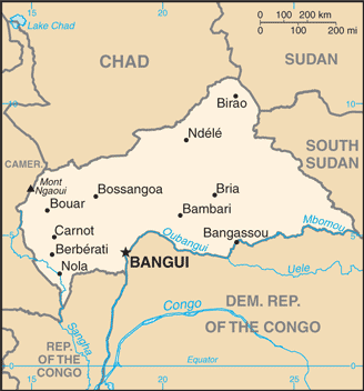
Central African Republic (GPS: 7 00 N, 21 00 E) is located in Central Africa, north of the Democratic Republic of the Congo. The country’s area measurements are total: 622,984 sq km; land: 622,984 sq km, water: 0 sq km. This sovereign state is slightly smaller than Texas. The total irrigated land is 10 sq km (2012).
One of the essential features of the Central African Republic: Landlocked (enclosed or nearly enclosed by land). Almost the precise center of Africa.
It’s significant, and simultaneously, the principal city, Bangui’s GPS coordinates are 4 22 N 18 35 E. Bangui’s local time is 6 hours ahead of Washington DC during Standard Time. The capital’s time difference: UTC+1.
Google Maps Central African Republic and Bangui, Africa
About the Central African Republic in detail
Flag of Central African Republic
Map of Central African Republic
The former French colony of Ubangi-Shari became the Central African Republic upon independence in 1960. After three tumultuous decades of misrule – mostly by military governments – civilian rule was established in 1993 but lasted only a decade. In March 2003, President Ange-Felix PATASSE was deposed in a military coup led by General Francois BOZIZE, who established a transitional government. Elections held in 2005 affirmed General BOZIZE as president; He was reelected in 2011 in voting widely viewed as flawed. The government still lacks full control of the countryside, where lawlessness persists. Several rebel groups joined together in early December 2012 to launch a series of attacks that left them in control of numerous towns in the northern and central parts of the country.
The rebels – unhappy with BOZIZE’s government – participated in peace talks in early January 2013, which resulted in a coalition government, including the rebellion’s leadership. In March 2013, the coalition government dissolved, rebels seized the capital, and President BOZIZE fled the country. Rebel leader Michel DJOTODIA assumed the presidency, and the following month established a National Transitional Council (CNT). In January 2014, the CNT elected Catherine SAMBA-PANZA as interim president. Elections completed in March 2016 installed independent candidate Faustin-Archange TOUADERA as president; He continues to work towards peace between the government and armed groups and develops disarmament, demobilization, and reintegration repatriation program to reintegrate the armed groups into society.
Central African Republic’s names conventional long form: Central African Republic, conventional short form: none, local long form: Republique Centrafricaine, local short form: none, former: Ubangi-Shari, Central African Empireabbreviation: CAR, etymology: self-descriptive name specifying the country’s location on the continent; “Africa” is derived from the Roman designation of the area corresponding to present-day Tunisia “Africa terra,” which meant “Land of the Afri” (the tribe resident in that area), but which eventually came to mean the entire continent. Self-descriptive name specifying the country’s location on the continent; “Africa” is derived from the Roman designation of the area corresponding to present-day Tunisia “Africa terra,” which meant “Land of the Afri” (the tribe resident in that area), but which eventually came to mean the entire continent.
Central African Republic’s terrain is typically vast, flat to rolling plateau; scattered hills in northeast and southwest. The country’s mean elevation: 635 m, elevation extremes; lowest point: Oubangui River 335 m, highest point: Mont Ngaoui 1,420 m.
The general climate in the country; tropical: hot, dry winters: mild to hot, wet summers.
The total number of border countries is 6, Cameroon 901 km, Chad 1,556 km, the Democratic Republic of the Congo 1,747 km, Republic of the Congo 487 km, South Sudan 1,055 km, Sudan 174 km are the neighboring nations with the indicated border lengths. Central African Republic’s coastline is 0 km (landlocked country), while its marital claims are: none. Waterways: 2,800 km (the primary navigable river is the Ubangi, which joins the River Congo; it was the traditional route for the export of products because it connected with the Congo-Ocean railway at Brazzaville; because of the warfare on both sides of the River Congo from 1997, importers and exporters preferred routes through Cameroon) (2011). Land use: agricultural land: 8.1%; arable land 2.9%; permanent crops 0.1%; permanent pasture 5.1%; forest: 36.2%; other: 55.7% (2011 estimate).
The population in the Central African Republic 5,745,062 (July 2018 estimate), urban population: 40% of total population (2015), major urban area’s population: BANGUI (capital) 794,000 (2015), while Central African Republic has N/A. Their spoken languages are French (official language), Sangho (lingua franca and national language), tribal languages. Main religions in the Central African Republic are indigenous beliefs 35%, Protestant 25%, Roman Catholic 25%, Muslim 15%note: animistic beliefs and practices strongly influence the Christian majority. The nation uses civil law system based on the French model. It is a(n) presidential republic, National holiday(s) Republic Day, 1 December (1958).
Economic overview for the country: Subsistence agriculture, together with forestry and mining, remains the backbone of the economy of the Central African Republic (CAR), with about 60% of the population living in outlying areas. The agricultural sector generates more than half of the estimated GDP, although statistics are unreliable in the conflict-prone country. Timber and diamonds account for most export earnings, followed by cotton. Significant economic development constraints include the CAR’s landlocked geography, flawed transportation system, mostly unskilled workforce, and legacy of misdirected macroeconomic policies. Factional fighting between the government and its opponents remains a drag on economic revitalization. Distribution of income is highly unequal, and grants from the international community can only partially meet humanitarian needs.
CAR shares a common currency with the Central African Monetary Union. The currency is pegged to the Euro. Since 2009, the IMF has worked closely with the government to institute reforms that have improved budget transparency, but other problems remain. The government’s additional spending in the run-up to the 2011 election worsened CAR’s fiscal situation. In 2012, the World Bank approved $125 million in funding for transport infrastructure and regional trade, focused on the route between CAR’s capital and Douala’s port in Cameroon. In July 2016, the IMF approved a three-year extended credit facility valued at $116 million; In mid-2017, the IMF completed a review of CAR’s fiscal performance and broadly approved of the government’s management, although issues with revenue collection, weak government capacity, and transparency remain.
The World Bank in late 2016, approved a $20 million grant to restore essential fiscal management, improve transparency, and assist with economic recovery. Participation in the Kimberley Process, a commitment to remove conflict diamonds from the global supply chain, led to a partially lifted the ban on diamond exports from CAR in 2015. Still, persistent insecurity is likely to constrain real GDP growth.
Natural resources of Central African Republic: diamonds, uranium, timber, gold, oil, hydropower.
Main export partners for the Central African Republic, Africa are Norway 52.2%, China 14.1%, the Democratic Republic of the Congo 8.3% (2015) for diamonds, timber, cotton, coffee, while the main import partners for the country are: Norway 39.6%, France 6.8%, US 4.6% (2015) for food, textiles, petroleum products, machinery, electrical equipment, motor vehicles, chemicals, pharmaceuticals.
When you visit this country in Africa, consider the natural hazards in the Central African Republic: Hot, dry, dusty harmattan winds affect northern areas, floods are common, while infectious diseases are a degree of risk: very high food or waterborne diseases: bacterial and protozoal diarrhea, hepatitis A and E, and typhoid fever vectorborne diseases: malaria and dengue fever respiratory disease: meningococcal meningitis water contact disease: schistosomiasis animal contact disease: rabies (2016). Also, note that the Central African Republic faces the following environmental issues: Water pollution, Tap water is not potable, Poaching, and mismanagement have diminished the country’s reputation as one of the last great wildlife refuges, Desertification, Deforestation, Soil erosion.
You may also be interested in the countries next to the Central African Republic around its total: 5,920 km border, like Cameroon, Chad, the Democratic Republic of the Congo, Republic of the Congo, South Sudan, Sudan.