Republic of the Congo (GPS: 1 00 S, 15 00 E) located in Central Africa, bordering the South Atlantic Ocean, between Angola and Gabon. The country’s area measurements are total: 342,000 sq km; land: 341,500 sq km, water: 500 sq km. This sovereign state is slightly smaller than Montana. The total irrigated land is 20 sq km (2012).
One of the essential features of the Republic of the Congo: About 70% of the population lives in Brazzaville, Pointe-Noire, or along the railroad between them.
It’s significant, and at the same time, the principal city, Brazzaville’s GPS coordinates are 4 15 S 15 17 E. Brazzaville’s local time is 6 hours ahead of Washington DC during Standard Time. The capital’s time difference: UTC+1.
Google Maps Republic of the Congo and Brazzaville, Africa
About the Republic of the Congo in detail
Flag of Republic of the Congo
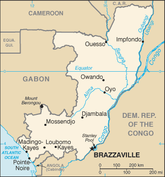
Map of Republic of the Congo
Upon independence in 1960, the former French region of Middle Congo became the Republic of the Congo. A quarter-century of experimentation with Marxism was abandoned in 1990, and a democratically elected government took office in 1992. A two-year civil war that ended in 1999 restored former Marxist President Denis SASSOU-Nguesso, who had ruled from 1979 to 1992, and sparked a short period of ethnic and political unrest that was resolved by a peace agreement in late 1999.
A new constitution adopted three years later provided a multi-party system and a seven-year presidential term, and elections arranged shortly after that installed SASSOU-Nguesso. Following a renewed fighting year, President SASSOU-Nguesso and southern-based rebel groups agreed to a final peace accord in March 2003. SASSOU-Nguesso was re-elected in 2009 and, after passing a referendum allowing him to run for a third term, was reelected again in 2016. The Republic of Congo is one of Africa’s largest petroleum producers, but with declining production, new offshore oil will need to sustain its oil earnings over the long term.
Republic of the Congo’s names conventional long form: the Republic of the Congo, traditional short way: Congo (Brazzaville), local long form: Republique du Congo, local short form: Congo, former: French Congo, Middle Congo, People’s Republic of the Congo, Congo/Brazzaville, etymology: named for the Congo River, which makes up much of the country’s eastern border; the river name derives from Kongo, a Bantu kingdom that occupied its mouth at the time of Portuguese discovery in the late 15th century and whose name stems from its people the Bakongo, meaning “hunters.” Named for the Congo River, which makes up much of the country’s eastern border; The river Name derives from Kongo, a Bantu kingdom that occupied its mouth at the time of Portuguese discovery in the late 15th century and whose name stems from its people the Bakongo, meaning “hunters.”
Republic of the Congo’s terrain is typically coastal plain, southern basin, central plateau, northern basin. The country’s mean elevation: 430 m, elevation extremes; lowest point: Atlantic Ocean 0 m, highest point: Mount Berongou 903 m.
The country’s general climate is tropical: rainy season (March to June): the dry season (June to October): persistent high temperatures and humidity: particularly enervating climate astride the Equator.
The total number of border countries is 5, Angola 231 km, Cameroon 494 km, Central African Republic 487 km, the Democratic Republic of the Congo 1,229 km, Gabon 2,567 km are the neighboring nations with the indicated border lengths. Republic of the Congo’s coastline is 169 km, while its marital claims are: territorial sea: 12 nautical miles, contiguous zone: 24 nautical miles, exclusive economic zone: 200 nautical miles. Waterways: 1,120 km (commercially navigable on Congo and Oubanqui Rivers above Brazzaville; there are many ferries across the river to Kinshasa; the Congo south of Brazzaville-Kinshasa to the coast is not navigable because of rapids, necessitating a rail connection to Pointe Noire; other rivers are used for local traffic only) (2011). Land use: agricultural land: 31.1%; arable land 1.6%; permanent crops 0.2%; permanent pasture 29.3%; forest: 65.6%; other: 3.3% (2011 estimate).
The population in the Republic of the Congo 5,062,021 (July 2018 estimate), urban population: 65.4% of total population (2015), major urban area’s population: BRAZZAVILLE (capital) 1.888 million; Pointe-Noire 969,000 (2015), while the Republic of the Congo has N/A. Their spoken languages are French (official language), Lingala and Monokutuba (lingua franca trade languages), many local languages and dialects (of which Kikongo is the most widespread). Main religions in Republic of the Congo are Roman Catholic 33.1%, Awakening Churches/Christian Revival 22.3%, Protestant 19.9%, Salutiste 2.2%, Muslim 1.6%, Kimbanguiste 1.5%, other 8.1%, none 11.3% (2010 estimate). The nation uses a mixed legal system of French civil law and customary law. It is a(n) presidential republic, National holiday(s) Independence Day, 15 August (1960).
Economic overview for the country: The Republic of the Congo’s economy is a mixture of subsistence farming, an industrial sector based mainly on oil and support services, and government spending. Oil has supplanted forestry as the mainstay of the economy, providing a significant share of government revenues and exports. Natural gas is increasingly being converted to electricity rather than being flared, significantly improving energy prospects. New mining projects, particularly iron ore, which entered production in late 2013, may add as much as $1 billion to annual government revenue.
The Republic of the Congo is a member of the Central African Economic and Monetary Community (CEMAC) and shares a common currency, the Central African Franc, with five other member states in the region. The current administration faces difficult economic challenges of stimulating recovery and reducing poverty. The drop in oil prices that began in 2014 has constrained government spending; lower oil prices forced the government to cut more than $1 billion in planned expenditures. The fiscal deficit amounted to 11% of GDP in 2017. The government’s inability to pay civil servant salaries has resulted in multiple rounds of strikes by many groups, including doctors, nurses, and teachers. In the wake of a multi-year recession, the country reached out to the IMF in 2017 for a new program; The IMF noted that its continued dependence on oil, unsustainable debt, and significant governance weakness are critical impediments’s economy. In 2018, the country’s external debt level will approach 120% of GDP. The IMF urged the government to renegotiate debts levels to sustainable levels before it agreed to a new macroeconomic adjustment package.
Natural resources of the Republic of the Congo: petroleum, timber, potash, lead, zinc, uranium, copper, phosphates, gold, magnesium, natural gas, hydropower.
Main export partners for Republic of the Congo, Africa are China 42.1%, Italy 16.9%, US 4.9%, India 4.7%, Portugal 4.2% (2015) for petroleum, lumber, plywood, sugar, cocoa, coffee, diamonds, while the main import partners for the country are: China 20.3%, France 14.2%, South Korea 9.8%, US 4.9%, UK 4.4%, Italy 4.1%, India 4.1% (2015) for capital equipment, construction materials, foodstuffs.
When you visit this country in Africa, consider the natural hazards in the Republic of the Congo: Seasonal flooding, while infectious diseases are a degree of risk: very high food or waterborne diseases: bacterial and protozoal diarrhea, hepatitis A, and typhoid fever vectorborne disease: malaria and dengue fever animal contact disease: rabies water contact disease: schistosomiasis (2016). Also, note that the Republic of the Congo faces the following environmental issues: Air pollution from vehicle emissions, water pollution from raw sewage, Tap water is not potable, Deforestation, wildlife protection.
You may also be interested in the countries next to the Republic of the Congo around its total: 5,008 km border, like Angola, Cameroon, Central African Republic, the Democratic Republic of the Congo, Gabon.