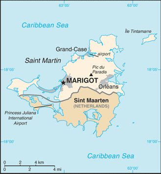
Saint Martin (GPS: 18 05 N, 63 57 W) is located in the Caribbean, located in the Leeward Islands (northern) group; French part of the island of Saint Martin in the Caribbean Sea; Saint Martin lies east of the USVirgin Islands. The country’s area measurements are total: 54.4 sq km; land: 54.4 sq km, water: NEGL. This sovereign state is more than one-third the size of Washington, DC. The total irrigated land is N/A.
One of the crucial features of Saint Martin: The southern border is shared with Sint Maarten, a country within the Kingdom of the Netherlands. Together, these two entities make up the smallest landmass in the world shared by two self-governing states.
It’s significant, and at the same time, the principal city, Marigot’s GPS coordinates are 18 04 N 63 05 W. Marigot’s local time is 1 hour ahead of Washington DC during Standard Time. The capital’s time difference: UTC-4.
Google Maps Saint Martin and Marigot, Central America and the Caribbean
About Saint Martin in detail
Flag of Saint Martin
Map of Saint Martin
Although sighted by Christopher COLUMBUS in 1493 and claimed for Spain, it was the Dutch who occupied the island in 1631 to exploit its salt deposits. The Spanish retook the island in 1633 but continued to be harassed by the Dutch. The Spanish finally relinquished Saint Martin to the French and Dutch, who divided it between themselves in 1648. Friction between the two sides caused the border to frequently fluctuate over the next two centuries, with the French eventually holding the greater portion of the island (about 61%).
The cultivation of sugar cane introduced African slavery to the island in the late 18th century; The practice was not abolished until 1848. The island became a free port in 1939; The tourism industry was dramatically expanded during the 1970s and 1980s. In 2003, the populace of Saint Martin voted to secede from Guadeloupe and in 2007, the northern portion of the island became a French overseas collectivity. In 2010, the southern Dutch part of the island became the independent nation of Sint Maarten within the Kingdom of the Netherlands. On 6 September 2017, Hurricane Irma passed over the island of Saint Martin causing extensive damage to roads, communications, electrical power, and housing; The UN estimated that 90% of the buildings were damaged or destroyed.
Saint Martin’s names conventional long form: Overseas Collectivity of Saint Martin, conventional short form: Saint Martin, local long form: Collectivite d’outre mer de Saint-Martin, local short form: Saint-Martin, etymology: explorer Christopher COLUMBUS named the island after Saint MARTIN of Tours because the 11 November 1493 day of discovery was the saint’s feast day. Explorer Christopher COLUMBUS named the island after Saint MARTIN of Tours because the 11 November 1493 day of discovery was the saint’s feast day.
Saint Martin’s terrain is typically N/A. The country’s mean elevation: N/A, elevation extremes; lowest point: Caribbean Ocean 0 m, highest point: Pic du Paradis 424 m.
The country’s general climate temperature averages 27-29 degrees Celsius all year long: low humidity, gentle trade winds, brief, intense rain showers: hurricane season stretches from July to November.
The total number of border countries is 1, Sint Maarten 16 km are the neighboring nations with the indicated border lengths. Saint Martin’s coastline is 58.9 km (for the entire island), while its marital claims are: N/A. Waterways: N/A. Land use: N/A.
The population in Saint Martin 32,284 (July 2018 estimate), N/A, central urban area’s population: N/A, while Saint Martin has most of the community is found along the coast, with the largest concentrations around Marigot, Orleans, and Grand-Case. Their spoken languages are French (official language), English, Dutch, French Patois, Spanish, Papiamento (a dialect of Netherlands Antilles). The main religions in Saint Martin are Roman Catholic, Jehovah’s Witnesses, Protestant, Hindu. The nation uses French civil law. It is a(n) N/A, National holiday(s) Fete de la Federation, 14 July (1789).
Economic overview for the country: The economy of Saint Martin centers on tourism, with 85% of the labor force engaged in this sector. Over one million visitors come to the island each year, most arriving through the Princess Juliana International Airport in Sint Maarten. The financial industry is also vital to Saint Martin’s economy as it facilitates financial mediation for its thriving tourism sector. No significant agriculture and limited local fishing mean that almost all food must be imported.
Energy resources and manufactured goods are also imported, primarily from Mexico and the US. Saint Martin is reported to have one of the highest per capita incomes in the Caribbean. As with the rest of the Caribbean, Saint Martin’s financial sector has to deal with losing correspondent banking relationships. In September 2017, Hurricane Irma destroyed 95% of the French side of Saint Martin. Along the coastline of Marigot, the economy’s nerve center, the storm wiped out restaurants, shops, banks, and open-air markets, impacting more than 36,000 inhabitants.
Natural resources of Saint Martin: salt.
Main export partners for Saint Martin, Central America, and the Caribbean are N/A for N/A, while the country’s main import partners are: N/A for crude petroleum, food, manufactured items.
When you visit this country in Central America and the Caribbean, consider the natural hazards in Saint Martin: Subject to hurricanes from July to November, while infectious diseases are noted: active local transmission of Zika virus by Aedes species mosquitoes has been identified in this country (as of August 2016); it poses a significant risk (a large number of cases possible) among US citizens if bitten by an infective mosquito; other less common ways to get Zika are through sex, via blood transfusion, or during pregnancy, in which the pregnant woman passes Zika virus to her fetus (2016). Also, note that Saint Martin faces the following environmental issues: Excessive population pressure (increasing settlement), waste management, Salinity intrusions into the mainland of the island, Freshwater supply is dependent on the desalination of seawater, Overexploitation of marine resources (reef fisheries, coral and shell), Indiscriminate anchoring of boat damages coral reefs, causing underwater pollution and changes the sediment dynamics of Saint Martin’s Island.
You may also be interested in the countries next to Saint Martin around its total: 16 km border, like Sint Maarten.