Sint Maarten (GPS: 18 4 N, 63 4 W) located in the Caribbean, located in the Leeward Islands (northern) group; Dutch part of the island of Saint Martin in the Caribbean Sea; Sint Maarten lies east of the USVirgin Islands. The country’s area measurements are total: 34 sq km; land: 34 sq km, water: 0 sq km. This sovereign state is one-fifth the size of Washington, DC. The total irrigated land is N/A.
One of the essential features of Sint Maarten: The northern border is shared with the French overseas collectivity of Saint Martin. Together, these two entities make up the smallest landmass in the world shared by two self-governing states.
It’s significant, and at the same time, the principal city, Philipsburg’s GPS coordinates are 18 1 N 63 2 W. Philipsburg’s local time is 1 hour ahead of Washington DC during Standard Time. The capital’s time difference: UTC-4.
Google Maps Sint Maarten and Philipsburg, Central America and the Caribbean
About Sint Maarten in detail
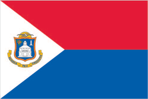
Flag of Sint Maarten
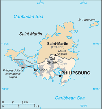
Map of Sint Maarten
Although sighted by Christopher COLUMBUS in 1493 and claimed for Spain, it was the Dutch who occupied the island in 1631 and began exploiting its salt deposits. The Spanish retook the island in 1633, but the Dutch continued to assert their claims. The Spanish finally relinquished the island of Saint Martin to the French and Dutch, who divided it between themselves in 1648. The establishment of cotton, tobacco, and sugar plantations dramatically expanded African slavery on the island in the 18th and 19th centuries; The practice was not abolished in the Dutch half until 1863. The island’s economy declined until 1939 when it became a free port; The tourism industry was dramatically expanded beginning in the 1950s.
In 1954, Sint Maarten and several other Dutch Caribbean possessions became part of the Kingdom of the Netherlands as the Netherlands Antilles. In a 2000 referendum, the citizens of Sint Maarten voted to become a self-governing country within the Kingdom of the Netherlands, effective October 2010. On 6 September 2017, Hurricane Irma hit Saint Martin/Sint Maarten, causing extensive damage to roads, communications, electrical power, and housing. The UN estimated the storm destroyed or damaged 90% of the buildings, and Princess Juliana International Airport was heavily damaged and closed to commercial air traffic for five weeks.
Sint Maarten’s names Dutch long form: Land Sint MaartenDutch short form: Sint MaartenEnglish long form: Country of Sint Maarten, English short form: Sint Maarten, former: Netherlands Antilles; Curacao and Dependencies, etymology: explorer Christopher COLUMBUS named the island after Saint MARTIN of Tours because the 11 November 1493 day of discovery was the saint’s feast day. Explorer Christopher COLUMBUS named the island after Saint MARTIN of Tours because the 11 November 1493 day of discovery was the saint’s feast day.
Sint Maarten’s terrain is typically low, hilly terrain, volcanic origin. The country’s mean elevation: N/A, elevation extremes; lowest point: the Caribbean Sea 0 m, highest point: Mount Flagstaff 386 m.
The country’s general climate, tropical marine climate, ameliorated by northeast trade winds, results in moderate temperatures: average rainfall of 150 cm/year: hurricane season stretches from July to November.
The total number of border countries is 1, Saint Martin (France) 16 km are the neighboring nations with the indicated border lengths. Sint Maarten’s coastline is 58.9 km (for the entire island), while its marital claims are: territorial sea: 12 nautical miles, exclusive fishing zone: 12 nautical miles. Waterways: N/A. Land use: N/A.
The population in Sint Maarten 42,677 (July 2018 estimate), urban population: 100% of total population (2015), major urban area’s population: PHILIPSBURG (capital) 1,327 (2011), while Sint Maarten has most populous areas are Lower Prince’s Quarter (north of Philipsburg), followed closely by Cul de Sac. Their spoken languages are: English (official language) 67.5%, Spanish 12.9%, Creole 8.2%, Dutch (official language) 4.2%, Papiamento (a Spanish-Portuguese-Dutch-English dialect) 2.2%, French 1.5%, other 3.5% (2001 census). Main religions in Sint Maarten are Protestant 41.9% (Pentecostal 14.7%, Methodist 10.0%, Seventh Day Adventist 6.6%, Baptist 4.7%, Anglican 3.1%, other Protestant 2.8%), Roman Catholic 33.1%, Hindu 5.2%, Christian 4.1%, Jehovah’s Witness 1.7%, Evangelical 1.4%, Muslim/Jewish 1.1%, other 1.3% (includes Buddhist, Sikh, Rastafarian), none 7.9%, no response 2.4% (2011 estimate). The nation uses based on Dutch civil law system with some English common law influence. It is a(n) N/A, National holiday(s) King’s Day (birthday of King WILLEM-ALEXANDER), 27 April (1967).
Economic overview for the country: The economy of Sint Maarten centers around tourism, with nearly four-fifths of the labor force engaged in this sector. Almost 1.8 million visitors came to the island by cruise ship, and roughly 500,000 visitors arrived through Princess Juliana International Airport in 2013. Cruise ships and yachts also call on Sint Maarten’s numerous ports and harbors. Limited agriculture and local fishing mean that almost all food must be imported. Energy resources and manufactured goods are also imported. Sint Maarten had the highest per capita income among the five islands that formerly comprised the Netherlands Antilles.
Natural resources of Sint Maarten: fish, salt.
Main export partners for Sint Maarten, Central America, and the Caribbean are N/A for sugar, while the main import partners for the country are: N/A for N/A.
When you visit this country in Central America and the Caribbean, consider the natural hazards in Sint Maarten: Subject to hurricanes from July to November, while infectious diseases are noted: active local transmission of Zika virus by Aedes species mosquitoes has been identified in this country (as of August 2016); it poses a substantial risk (a large number of cases possible) among US citizens if bitten by an infective mosquito; other less common ways to get Zika are through sex, via blood transfusion, or during pregnancy, in which the pregnant woman passes Zika virus to her fetus (2016). Also, note that Sint Maarten faces the following environmental issues: Scarcity of potable water (increasing percentage provided by desalination), Inadequate solid waste management, Pollution from construction, chemical runoff, and sewage harms reefs.
You may also be interested in the countries next to Sint Maarten around its total: 16 km border, like Saint Martin.