Bolivia (GPS: 17 00 S, 65 00 W), located in Central South America, southwest of Brazil. The country’s area measurements are total: 1,098,581 sq km; land: 1,083,301 sq km, water: 15,280 sq km. This sovereign state is slightly less than three times the size of Montana. The total irrigated land is 3,000 sq km (2012).
One of the important features of Bolivia: Landlocked (enclosed or nearly enclosed by land). Shares control of Lago Titicaca, the world&’s highest navigable lake (elevation 3,805 m), with Peru. The southern regions of Peru and the extreme northwestern part of Bolivia are considered the place of origin for the common potato.
It’s significant, and at the same time, the principal city, La Paz’s GPS coordinates are 16 30 S 68 09 W. La Paz’s local time is 1 hour ahead of Washington DC during Standard Time. The capital’s time difference: UTC-4.
For more information on Bolivia, please scroll down below the Google Maps.
Google Maps Bolivia and La Paz, South America
About Bolivia in detail
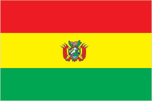
Flag of Bolivia
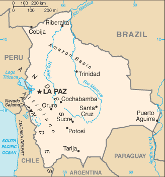
Map of Bolivia
Bolivia, named after independence fighter Simon BOLIVAR, broke away from Spanish rule in 1825; Much of its subsequent history has consisted of a series of coups and countercoups, with the last coup occurring in 1978. Democratic civilian rule was established in 1982, but leaders have faced difficult problems of deep-seated poverty, social unrest, and illegal drug production. In December 2005, Bolivians elected Movement Toward Socialism leader Evo MORALES president – by the widest margin of any leader since the restoration of civilian rule in 1982 – after he ran on a promise to change the country’s traditional political class and empower the nation’s poor, indigenous majority. In December 2009 and October 2014, President MORALES easily won reelection. His party maintained control of the government’s legislative branch, which has allowed him to continue his process of change.
In February 2016, MORALES narrowly lost a referendum to approve a constitutional amendment that would have allowed him to compete in the 2019 presidential election. However, a 2017 Supreme Court ruling stating that term limits violate human rights provided the justification for MORALES to be chosen by his party to run again in 2019. MORALES attempted to claim victory in the 20 October 2019 election, but widespread allegations of electoral fraud, rising violence, and pressure from the military ultimately forced him to flee the country. An interim government is preparing new elections for 2020.
Bolivia’s names conventional long form: the Plurinational State of Bolivia, traditional short form: Bolivia, local long form: Estado Plurinacional de Bolivia, local short form: Bolivia, etymology: the country named after Simon BOLIVAR, a 19th-century leader in the South American wars for independence.
Bolivia’s terrain is typically rugged Andes Mountains with a highland plateau (Altiplano), hills, and the Amazon Basin’s lowland plains. The country’s mean elevation: 1,192 m, elevation extremes; lowest point: Rio Paraguay 90 m, highest point: Nevado Sajama 6,542 m.
The general climate in the country; varies with altitude: humid and tropical to cold and semiarid.
The total number of border countries is 5, Argentina 942 km, Brazil 3,403 km, Chile 942 km, Paraguay 753 km, Peru 1,212 km are the neighboring nations with the indicated border lengths. Bolivia’s coastline is 0 km (landlocked country), while its marital claims are: none. Waterways: 10,000 km (commercially navigable almost exclusively in the country’s northern and eastern parts) (2012). Land use: agricultural land: 34.3%; arable land 3.6%; permanent crops 0.2%; permanent pasture 30.5%; forest: 52.5%; other: 13.2% (2011 estimate).
The population in Bolivia 11,306,341 (July 2018 estimate), urban population: 68.5% of total population (2015), central urban area’s population: Santa Cruz 2.107 million; LA PAZ (capital) 1.816 million; Cochabamba 1.24 million; Sucre (constitutional capital) 372,000 (2015), while Bolivia has a high altitude plain in the west between two cordillera of the Andes, known as the Altiplano, is the focal area for most of the population; a dense settlement pattern is also found in and around the city of Santa Cruz, located on the eastern side of the Andes.
Their spoken languages are: Spanish (official language) 60.7%, Quechua (official language) 21.2%, Aymara (official language) 14.6%, foreign languages 2.4%, Guarani (official language) 0.6%, other native languages 0.4%, none 0.1%. Note: Bolivia’s 2009 constitution designates Spanish, and all indigenous languages as the official language; 36 indigenous languages are specified, including extinct (2001 estimate). Main religions in Bolivia are Roman Catholic 76.8%, Evangelical and Pentecostal 8.1%, Protestant 7.9%, other 1.7%, none 5.5% (2012 estimate). The nation uses civil law system with influences from Roman, Spanish, canon (religious), French, and indigenous law. It is a(n) presidential republic, National holiday(s) Independence Day, 6 August (1825).
Economic overview for the country: Bolivia is a resource rich country with strong growth attributed to captive markets for natural gas exports to Brazil and Argentina. However, the country remains one of the least developed countries in Latin America because of state-oriented policies that deter investment. Following an economic crisis during the early 1980s, reforms in the 1990s spurred private investment, stimulated economic growth, and cut poverty rates. The period 2003-2005 was characterized by political instability, racial tensions, and violent protests against plans – subsequently abandoned – to export Bolivia’s newly discovered natural gas reserves to large Northern Hemisphere markets.
In 2005-2006, the government passed hydrocarbon laws that imposed significantly higher royalties and required foreign firms then operating under risk-sharing contracts to surrender all production to the state energy company in exchange for a predetermined service fee; The laws engendered much public debate. High commodity prices between 2010 and 2014 sustained rapid growth and large trade surpluses, with GDP growing 6.8% in 2013 and 5.4% in 2014. The global decline in oil prices that began in late 2014 exerted downward pressure on the price Bolivia receives for exported gas and resulted in lower GDP growth rates – 4.9% in 2015 and 4.3% in 2016 – and losses in government revenue as well as fiscal and trade deficits.
A lack of foreign investment in the key sectors of mining and hydrocarbons, along with conflict among social groups, pose challenges for the Bolivian economy. In 2015, President Evo MORALES expanded efforts to court international investment and boosted Bolivia’s energy production capacity. MORALES passed an investment law and promised not to nationalize additional industries to improve the investment climate. In early 2016, the Government of Bolivia approved the 2016-2020 National Economic and Social Development Plan to maintain the growth of 5% and reduce poverty.
Main export partners for Bolivia, South America are Brazil 28.1%, Argentina 16.9%, US 12.1%, Colombia 6.3%, China 5.3%, Japan 4.7%, South Korea 4.3% (2015) for natural gas, mineral ores, gold, soybeans and soy products, tin, while the main import partners for the country are: China 17.9%, Brazil 16.5%, Argentina 11.8%, US 10.6%, Peru 6.2%, Japan 5.2%, Chile 4.6% (2015) for machinery, petroleum products, vehicles, iron and steel, plastics.
When you visit this country in South America, consider the natural hazards in Bolivia: Flooding in the northeast (March to April), volcanism: volcanic activity in Andes Mountains on the border with Chile, historically active volcanoes in this region are Irruputuncu (elevation 5,163 m), which last erupted in 1995, and Olca-Paruma, while infectious diseases are a degree of risk: very high food or waterborne diseases: bacterial diarrhea and hepatitis A vectorborne conditions: dengue fever, malaria, and yellow fever.
Note: active local transmission of Zika virus by Aedes species mosquitoes has been identified in this country (as of August 2016); it poses an important risk (a large number of cases possible) among US citizens if bitten by an infective mosquito; other less common ways to get Zika are through sex, via blood transfusion, or during pregnancy, in which the pregnant woman passes Zika virus to her fetus (2016). Also, note that Bolivia faces the following environmental issues: The clearing of land for agricultural purposes and the international demand for tropical timber are contributing to deforestation, Soil erosion from overgrazing and poor cultivation methods (including slash-and-burn agriculture), Desertification, Loss of biodiversity, Industrial pollution of water supplies used for drinking and irrigation.
You may also be interested in Bolivia’s surrounding countries around its total 7,252 km border, like Argentina, Brazil, Chile, Paraguay, Peru.