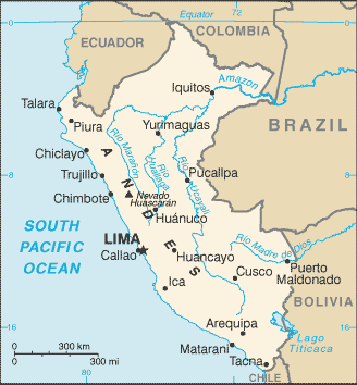
Peru (GPS: 10 00 S, 76 00 W) is located in Western South America, bordering the South Pacific Ocean, between Chile and Ecuador. The country’s area measurements are total: 1,285,216 sq km; land: 1,279,996 sq km, water: 5,220 sq km. This sovereign state is almost twice the size of Texas, slightly smaller than Alaska. The total irrigated land is 25,800 sq km (2012).
One of Peru’s essential features: Shares control of Lago Titicaca, the world’s highest navigable lake, with Bolivia. A small slope of Nevado Mismi, a 5,316 m peak, is the ultimate source of the Amazon River. Peru is one of the countries along the Ring of Fire, a belt of active volcanoes and earthquake epicenters bordering the Pacific Ocean. Up to 90% of the world’s earthquakes and some 75% of the world’s volcanoes occur within the Ring of Fire. On 19 February 1600, Mount Huaynaputina in the southern Peruvian Andes erupted in South America’s most enormous volcanic explosion in historical times.
Intermittent eruptions lasted until 5 March 1600 and pumped an estimated 16 to 32 million metric tons of particulates into the atmosphere reducing the amount of sunlight reaching the earth’s surface and affecting weather worldwide. Over the next two and a half years, millions died worldwide in famines from bitterly cold winters, cool summers, and the loss of crops and animals. The southern regions of Peru and the extreme northwestern part of Bolivia are considered the place of origin for the common potato.
It’s significant, and simultaneously, the principal city, Lima’s GPS coordinates, are 12 03 S 77 03 W. Lima’s local time is the same as Washington DC during Standard Time. The capital’s time difference: UTC-5.
For more information on Peru, please scroll down below the Google Maps.
Google Maps Peru and Lima, South America
About Peru in detail
Flag of Peru
Map of Peru
Ancient Peru was the seat of several prominent Andean civilizations, most notably that of the Incas, whose empire was captured by Spanish conquistadors in 1533. Peru declared its independence in 1821, and the remaining Spanish forces were defeated in 1824. After a dozen years of military rule, Peru returned to democratic leadership in 1980 but experienced economic problems and a violent insurgency growth. President Alberto FUJIMORI’s election in 1990 ushered in a decade that saw a dramatic turnaround in the economy and significant progress in curtailing guerrilla activity. Nevertheless, the president’s increasing reliance on authoritarian measures and an economic slump in the late 1990s generated mounting dissatisfaction with his regime, which led to his resignation in 2000.
A caretaker government oversaw a new election in the spring of 2001, which installed Alejandro TOLEDO Manrique as the new head of government – Peru’s first democratically elected president of indigenous ethnicity. The presidential election of 2006 saw the return of Alan GARCIA Perez, who, after a disappointing presidential term from 1985 to 1990, oversaw a robust economic rebound. Former army officer Ollanta HUMALA Tasso was elected president in June 2011 and carried on the three preceding administrations’ sound, market-oriented economic policies.
Poverty and unemployment levels have fallen dramatically in the last decade, and today Peru boasts one of the best performing economies in Latin America. Pedro Pablo KUCZYNSKI Godard won a very narrow presidential runoff election in June 2016. Facing impeachment after evidence surfaced of his involvement in a vote-buying scandal, President KUCZYNSKI offered his resignation on 21 March 2018. Two days later, First Vice President Martin Alberto VIZCARRA Cornejo was sworn in as president. On 30 September 2019, President VIZCARRA invoked his constitutional authority to dissolve Peru’s Congress after months of battling with the body over anticorruption reforms. New congressional elections are scheduled for 26 January 2020.
Peru’s name conventional long form: Republic of Peru, traditional short form: Peru, local long form: Republica del Peru, local short form: Peru, etymology: exact meaning is obscure, but the name may derive from a native word “biru” meaning “river.” The same purpose is unknown, but the name may derive from a native term “biru,” meaning “river.”
Peru’s terrain is typically western coastal plain (costa), high and rugged Andes in the center (sierra), eastern lowland jungle of Amazon Basin (selva). The country’s mean elevation: 1,555 m, elevation extremes; lowest point: Pacific Ocean 0 m, highest point: Nevado Huascaran 6,768 m.
The general climate in the country; varies from tropical in the east to desert in the west: temperate to frigid in the Andes.
The total number of border countries is 5, Bolivia 1,212 km, Brazil 2,659 km, Chile 168 km, Colombia 1,494 km, Ecuador 1,529 km are the neighboring nations with the indicated border lengths. Peru’s coastline is 2,414 km, while its marital claims are: territorial sea: 200 nautical miles, continental shelf: 200 nautical miles. Waterways: 8,808 km (8,600 km of navigable tributaries on the Amazon system and 208 km on Lago Titicaca) (2011). Land use: agricultural land: 18.8%; arable land 3.1%; permanent crops 1.1%; permanent pasture 14.6%; forest: 53%; other: 28.2% (2011 estimate).
The population in Peru 31,331,228 (July 2018 estimate), urban population: 78.6% of total population (2015), central metropolitan area’s population: LIMA (capital) 9.897 million; Arequipa 850,000; Trujillo 798,000 (2015), while Peru has approximately one-third of the population resides along the coastal desert belt in the west, with a strong focus on the capital city of Lima; the Andean highlands, or sierra, which is strongly identified with the country’s Amerindian population, contains roughly half of the overall population; the eastern slopes of the Andes, and adjoining rainforest, are sparsely populated.
Their spoken languages are Spanish (official language) 84.1%, Quechua (official language) 13%, Aymara (official language) 1.7%, Ashaninka 0.3%, other native languages (includes a large number of minor Amazonian languages) 0.7%, other (includes foreign languages and sign language) 0.2% (2007 estimate). Main religions in Peru are Roman Catholic 81.3%, Evangelical 12.5%, other 3.3%, none 2.9% (2007 estimate). The nation uses civil law system. It is a(n) presidential republic, National holiday(s) Independence Day, 28 July (1821).
Economic overview for the country: Peru’s economy reflects its varied topography – an arid lowland coastal region, the central high sierra of the Andes, and the dense forest of the Amazon. A wide range of significant mineral resources are found in the mountainous and coastal areas, and Peru’s coastal waters provide excellent fishing grounds. Peru is the world’s second-largest producer of silver and copper. The Peruvian economy grew by an average of 5.6% per year from 2009-2013 with a stable exchange rate and low inflation. This growth was due partly to high international prices for Peru’s metals and minerals exports, which account for 55% of the country’s total exports. Growth slipped from 2014 to 2017 due to weaker world prices for these resources. Despite Peru’s strong macroeconomic performance, dependence on minerals and metals exports and imported foodstuffs makes the economy vulnerable to fluctuations in world prices.
Peru’s rapid expansion, coupled with cash transfers and other programs, has helped reduce the national poverty rate by over 35 percentage points since 2004. Still, inequality persists and continued to pose a challenge for the Ollanta HUMALA administration, which championed a social inclusion policy and a more equitable distribution of income. Poor infrastructure hinders the spread of growth to Peru’s non-coastal areas. The HUMALA administration passed several economic stimulus packages in 2014 to bolster growth, including reforms to environmental regulations to spur investment in Peru’s lucrative mining sector, a move that was opposed by some environmental groups. However, in 2015, mining investment fell as global commodity prices remained low and social conflicts plagued the sector. Peru’s free trade policy continued under the HUMALA administration; Since 2006, Peru has signed trade deals with the US, Canada, Singapore, China, Korea, Mexico, Japan, the EU, the European Free Trade Association, Chile, Thailand, Costa Rica, Panama, Venezuela, Honduras, concluded negotiations with Guatemala and the Trans-Pacific Partnership, and begun trade talks with El Salvador, India, and Turkey. Peru has also signed a trade pact with Chile, Colombia, and Mexico, called the Pacific Alliance, that seeks integration of services, capital, investment, and people’s movement.
Since the US-Peru Trade Promotion Agreement entered into force in February 2009, total trade between Peru and the US has doubled. President Pedro Pablo KUCZYNSKI succeeded HUMALA in July 2016 and focuses on economic reforms and free-market policies aimed at boosting investment in Peru. Mining output increased significantly in 2016-2017, which helped Peru attain one of the highest GDP growth rates in Latin America, and Peru should maintain strong growth in 2018. However, economic performance was depressed by delays in infrastructure mega-projects and the start of a corruption scandal associated with a Brazilian firm. Massive flooding in early 2017 also was a drag on growth, offset somewhat by additional public spending aimed at recovery efforts.
Natural resources of Peru: copper, silver, gold, petroleum, timber, fish, iron ore, coal, phosphate, potash, hydropower, natural gas.
Main export partners for Peru, South America, are China 22.1%, US 15.2%, Switzerland 8.1%, Canada 7% (2015) for copper, gold, lead, zinc, tin, iron ore, molybdenum, silver; crude petroleum and petroleum products, natural gas; coffee, asparagus, and other vegetables, fruit, apparel and textiles, fishmeal, fish, chemicals, fabricated metal products, and machinery, while the main import partners for the country are: China 22.7%, US 20.7%, Brazil 5.1%, Mexico 4.5% (2015) for petroleum and petroleum products, chemicals, plastics, machinery, vehicles, TV sets, power shovels, front-end loaders, telephones, and telecommunication equipment, iron and steel, wheat, corn, soybean products, paper, cotton, vaccines, and medicines.
When you visit this country in South America, consider the natural hazards in Peru: Earthquakes, tsunamis, flooding, landslides, mild volcanic activityvolcanism: volcanic activity in the Andes Mountains, Ubinas (elevation 5,672 m), which last erupted in 2009, is the country’s most active volcano, other historically active volcanoes include El Misti, Huaynaputina, Sabancaya, and Yucamane, while infectious diseases are a degree of risk: very high food or waterborne diseases: bacterial diarrhea, hepatitis A, and typhoid fever vectorborne disease: dengue fever, malaria, and Bartonellosis (Oroya fever).
Note: active local transmission of Zika virus by Aedes species mosquitoes has been identified in this country (as of August 2016); it poses a significant risk (a large number of cases possible) among US citizens if bitten by an infective mosquito; other less common ways to get Zika are through sex, via blood transfusion, or during pregnancy, in which the pregnant woman passes Zika virus to her fetus (2016). Also, note that Peru faces the following environmental issues: Deforestation (some the result of illegal logging), Overgrazing of the slopes of the costa and sierra leading to soil erosion, Desertification, Air pollution in Lima, Pollution of rivers and coastal waters from municipal and mining wastes, Overfishing.
You may also be interested in the countries next to Peru around its total: 7,062 km border, like Bolivia, Brazil, Chile, Colombia, Ecuador.