Angola (GPS: 12 30 S, 18 30 E) located in Southern Africa, bordering the South Atlantic Ocean, between Namibia and the Democratic Republic of the Congo. The country’s area measurements are total: 1,246,700 sq km; land: 1,246,700 sq km, water: 0 sq km. This sovereign state is slightly less than twice the size of Texas. The total irrigated land is 860 sq km (2012).
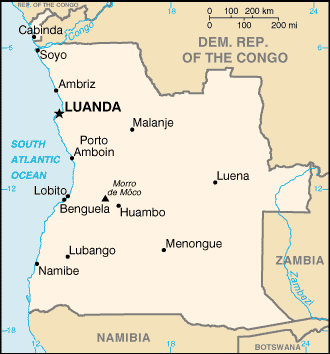
One of Angola’s essential features: The province of Cabinda is an exclamation, separated from the country’s rest by the Democratic Republic of the Congo.
It’s significant, and at the same time, the principal city, Luanda’s GPS coordinates are 8 50 S 13 13 E. Luanda’s local time is 6 hours ahead of Washington DC during Standard Time. The capital’s time difference: UTC+1.
For more information on Angola, please scroll down below the Google Maps.
Google Maps Angola and Luanda, Africa
About Angola in detail
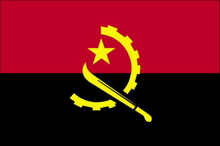
Flag of Angola
Map of Angola
Angola scores low on human development indexes despite using its large oil reserves to rebuild since the end of a 27-year civil war in 2002. Fighting between the Popular Movement for the Liberation of Angola (MPLA), led by Jose Eduardo DOS SANTOS, and the National Union for the Total Independence of Angola (UNITA), led by Jonas SAVIMBI, followed independence from Portugal in 1975. Peace seemed imminent in 1992 when Angola held national elections, but fighting picked up again in 1993. Up to 1.5 million lives may have been lost – and 4 million people displaced – during the more than a quarter-century of fighting. SAVIMBI’s death in 2002 ended UNITA’s insurgency and cemented the MPLA’s hold on power. DOS SANTOS stepped down from the presidency in 2017, having led the country since 1979. He pushed through a new constitution in 2010. Joao LOURENCO was elected president in August 2017 and became president of the MPLA in September 2018.
Angola’s names conventional long form: the Republic of Angola, conventional short form: Angola, local long form: Republica de Angola, local short form: Angola, former: People’s Republic of Angola, etymology: name derived by the Portuguese from the title “Angola” held by kings of the Ndongo (Ndongo was a kingdom in what is now northern Angola). Name derived by the Portuguese from the title “Angola” held by kings of the Ndongo (Ndongo was a kingdom in northern Angola).
Angola’s terrain is typically narrow coastal plain rises abruptly to vast interior plateau. The country’s mean elevation: 1,112 m, elevation extremes; lowest point: Atlantic Ocean 0 m, highest point: Moca 2,620 m.
The country’s general climate is semiarid in the south and along the coast to Luanda: north has a cold, dry season (May to October) and the hot, rainy season (November to April).
The total number of border countries is 4, Democratic Republic of the Congo 2,646 km (of which 225 km is the boundary of discontiguous Cabinda Province), Republic of the Congo 231 km, Namibia 1,427 km, Zambia 1,065 km are the neighboring nations with the indicated border lengths. Angola’s coastline is 1,600 km, while its marital claims are: territorial sea: 12 nautical miles, contiguous zone: 24 nautical miles, exclusive economic zone: 200 nautical miles. Waterways: 1,300 km (2011). Land use: agricultural land: 47.3%; arable land 3.8%; permanent crops 0.2%; permanent pasture 43.3%; forest: 46.8%; other: 5.9% (2011 estimate).
The population in Angola 30,355,880 (July 2018 estimate), urban population: 44% of total population (2015), major urban area’s population: LUANDA (capital) 5.506 million; Huambo 1.269 million (2015), while Angola has N/A. Their spoken languages are: Portuguese 71.2% (official language), Umbundu 23%, Kikongo 8.2%, Kimbundu 7.8%, Chokwe 6.5%, Nhaneca 3.4%, Nganguela 3.1%, Fiote 2.4%, Kwanhama 2.3%, Muhumbi 2.1%, Luvale 1%, other 3.6%. Note: most widely spoken languages; shares sum to more than 100% because some respondents gave more than one answer on the census (2014 estimate). Main religions in Angola are Roman Catholic 41.1%, Protestant 38.1%, other 8.6%, none 12.3% (2014 estimate). The nation uses civil legal system based on Portuguese civil law; no judicial review of legislation. It is a(n) presidential republic, National holiday(s) Independence Day, 11 November (1975).
Economic overview for the country: its oil sector overwhelmingly drives Angola’s economy. Oil production and its supporting activities contribute about 50% of GDP, more than 70% of government revenue, and more than 90% of the country’s exports; Angola is an OPEC member and subject to its direction regarding oil production levels. Diamonds contribute an additional 5% to exports. Subsistence agriculture provides the main livelihood for most people, but half of the country’s food is still imported. Increased oil production supported growth averaging more than 17% per year from 2004 to 2008.
A postwar reconstruction boom and resettlement of displaced persons led to high rates of growth in construction and agriculture as well. Some of the country’s infrastructure is still damaged or undeveloped from the 27-year-long civil war (1975-2002). However, since 2005, the government has used billions of dollars in credit from China, Brazil, Portugal, Germany, Spain, and the EU to help rebuild Angola’s public infrastructure. Land mines left from the war still mar the countryside, and as a result, the national military, international partners, and private Angolan firms all continue to remove them. The global recession that started in 2008 stalled Angola’s economic growth, and many construction projects stopped because Luanda accrued billions in arrears to foreign construction companies when government revenue fell. Lower prices for oil and diamonds also resulted in GDP falling 0.7% in 2016.
Angola formally abandoned its currency peg in 2009 but reinstituted it in April 2016 and maintains an overvalued exchange rate. In late 2016, Angola lost the last of its correspondent relationships with foreign banks, further exacerbating challenging currency problems. Since 2013 the central bank has consistently spent down reserves to defend the kwanza, gradually allowing a 40% depreciation since late 2014. Consumer inflation declined from 325% in 2000 to less than 9% in 2014, before rising to above 30% from 2015-2017. Continued low oil prices, the depreciation of the kwanza, and slower than expected growth in non-oil GDP have reduced growth prospects. However, several major international oil companies remain in Angola. Corruption, especially in the extractive sectors, is a major long-term challenge that poses an additional threat to the economy.
Natural resources of Angola: petroleum, diamonds, iron ore, phosphates, copper, feldspar, gold, bauxite, uranium.
Main export partners for Angola, Africa are China 43.8%, India 9.6%, US 7.7%, Spain 6.2%, South Africa 4.8%, France 4.4% (2015) for crude oil, diamonds, refined petroleum products, coffee, sisal, fish and fish products, timber, cotton, while the main import partners for the country are: China 22.1%, Portugal 13.8%, South Korea 11%, US 6.9%, South Africa 5%, UK 4.1%, France 4% (2015) for machinery and electrical equipment, vehicles and spare parts; medicines, food, textiles, military goods.
When you visit this country in Africa, consider the natural hazards in Angola: Locally heavy rainfall causes periodic flooding on the plateau, while infectious diseases are the degree of risk: very high food or waterborne diseases: bacterial and protozoal diarrhea, hepatitis A, typhoid fever vectorborne diseases: dengue fever, malaria water contact disease: schistosomiasis animal contact disease: rabies (2016). Also, note that Angola faces the following environmental issues: Overuse of pastures and subsequent soil erosion attributable to population pressures, Desertification, Deforestation of the tropical rain forest, in response to both international demands for tropical timber and domestic use as fuel, resulting in loss of biodiversity, Soil erosion contributing to water pollution and siltation of rivers and dams, Inadequate supplies of potable water.
You may also be interested in the countries next to Angola around its total: 5,369 km border, like the Democratic Republic of the Congo, Republic of the Congo, Namibia, Zambia.