Namibia (GPS: 22 00 S, 17 00 E) is located in Southern Africa, bordering the South Atlantic Ocean, between Angola and South Africa. The country’s area measurements are total: 824,292 sq km; land: 823,290 sq km, water: 1,002 sq km. This sovereign state is slightly more than half the size of Alaska. The total irrigated land is 80 sq km (2012).
One of the important features of Namibia: The Namib Desert, after which the country is named, is considered to be the oldest desert in the world. Namibia is the first country in the world to incorporate the protection of the environment into its constitution. Some 14% of the land is protected, including virtually the entire Namib Desert coastal strip. Namib-Naukluft National Park (49,768 sq km) is the largest game park in Africa and one of the world’s largest.
It’s significant, and simultaneously, the principal city, Windhoek’s GPS coordinates are 22 34 S 17 05 E. Windhoek’s local time is 6 hours ahead of Washington DC during Standard Time. The capital’s time difference: UTC+1, note; Daylight saving time: +1hr begins first Sunday in September; ends first Sunday in April.
For more information on Namibia, please scroll down below the Google Maps.
Google Maps Namibia and Windhoek, Africa
About Namibia in detail
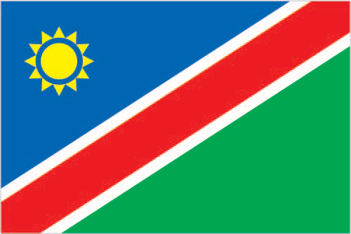
Flag of Namibia
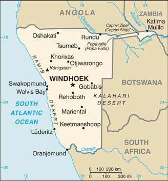
Map of Namibia
Namibia gained independence in 1990. Before independence, apartheid South Africa occupied the former German colony known as South-West Africa during World War I. It administered it as a mandate until after World War II, when it annexed the territory. In 1966, the Marxist South-West Africa People’s Organization (SWAPO) guerrilla group launched a war of independence for the area that became Namibia. Still, it was not until 1988 that South Africa agreed to end its administration by a UN peace plan for the entire region. SWAPO has governed Namibia since the country won independence, though the party has dropped much of its Marxist ideology. President Hage GEINGOB was elected in 2014 in a landslide victory, replacing Hifikepunye POHAMBA, who stepped down after serving two terms. SWAPO retained its parliamentary supermajority in the 2014 elections and established a system of gender parity in parliamentary positions.
Namibia’s names conventional long form: the Republic of Namibia, traditional short form: Namibia, local long form: the Republic of Namibia, local short form: Namibia, former: German South-West Africa (Deutsch Suedwest Afrika), South-West Africa, etymology: named for the coastal Namib Desert; the name “Namib” means “vast place” in the Nama/Damara language. Named for the coastal Namib Desert; The Name “Namib” means “vast place” in the Nama/Damara language.
Namibia’s terrain is typically mostly high plateau; the Namib Desert along the coast; the Kalahari Desert in the east. The country’s mean elevation: 1,141 m, elevation extremes; lowest point: Atlantic Ocean 0 m, highest point: Konigstein 2,606 m.
The general climate in the country; desert: hot, dry: rainfall sparse and erratic.
The total number of border countries is 4, Angola 1,427 km, Botswana 1,544 km, South Africa 1,005 km, Zambia 244 km are the neighboring nations with the indicated border lengths. Namibia’s coastline is 1,572 km, while its marital claims are: territorial sea: 12 nautical miles, contiguous zone: 24 nautical miles, exclusive economic zone: 200 nautical miles. Waterways: N/A. Land use: agricultural land: 47.2%; arable land 1%; permanent crops 0%; permanent pasture 46.2%; forest: 8.8%; other: 44% (2011 estimate).
The population in Namibia 2,533,224 (July 2018 estimate), urban population: 46.7% of total population (2015), major urban area’s population: WINDHOEK (capital) 368,000 (2015), while Namibia has N/A. Their spoken languages are: Oshiwambo languages 48.9%, Nama/Damara 11.3%, Afrikaans 10.4% (the common language of most of the population and about 60% of the white population), Otjiherero languages 8.6%, Kavango languages 8.5%, Caprivi languages 4.8%, English (official language) 3.4%, other African languages 2.3%, other 1.7%. Note: Namibia has 13 recognized national languages, including ten indigenous African languages and 3 Indo-European languages (2011 estimate). Namibia’s main religions are Christian 80% to 90% (at least 50% Lutheran), indigenous beliefs 10% to 20%. The nation uses a mixed legal system of uncodified civil law based on Roman-Dutch law and customary law. It is a(n) presidential republic, National holiday(s) Independence Day, 21 March (1990).
Economic overview for the country: Namibia’s economy depends heavily on the extraction and processing of minerals for export. Mining accounts for about 12.5% of GDP but provides more than 50% of foreign exchange earnings. Rich alluvial diamond deposits make Namibia a primary source for gem-quality diamonds. Marine diamond mining is increasingly important as the terrestrial diamond supply has dwindled. The rising cost of mining diamonds, especially from the sea, combined with increased diamond production in Russia and China, has reduced profit margins. Namibian authorities have emphasized the need to add value to raw materials, do more in-country manufacturing, and exploit the services market, especially in the logistics and transportation sectors. Namibia is one of the world’s largest producers of uranium. The Chinese-owned Husab uranium mine began producing uranium ore in 2017 and is expected to reach full production in August 2018 and produce 15 million pounds of uranium a year. Namibia also produces large quantities of zinc and is a smaller producer of gold and copper.
Namibia’s economy remains vulnerable to world commodity price fluctuations and drought. Namibia normally imports about 50% of its cereal requirements; In drought years, food shortages are problematic in rural areas. A high per capita GDP, relative to the region, obscures one of the world’s most unequal income distributions; The current government has prioritized exploring wealth redistribution schemes while maintaining a pro-business environment. GDP growth in 2017 slowed to about 1%, however, due to contractions in both the construction and mining sectors, as well as an ongoing drought. Growth is expected to recover modestly in 2018. A five-year Millennium Challenge Corporation compact ended in September 2014. As an upper-middle-income country, Namibia is ineligible for a second compact.
The Namibian economy is closely linked to South Africa, with the Namibian dollar pegged one-to-one to the South African rand. Namibia receives 30%-40% of its revenues from the Southern African Customs Union (SACU); Volatility in Namibia’s annual SACU allotment and global mineral prices complicates budget planning.
Natural resources of Namibia: diamonds, copper, uranium, gold, silver, lead, tin, lithium, cadmium, tungsten, zinc, salt, hydropower, fish. Note suspected deposits of oil, coal, and iron ore.
Main export partners for Namibia, Africa are N/A for diamonds, copper, gold, zinc, lead, uranium, cattle, white fish, and mollusks, while the country’s main import partners are: N/A for foodstuffs; petroleum products and fuel, machinery and equipment, chemicals.
When you visit this country in Africa, consider the natural hazards in Namibia: Prolonged periods of drought, while infectious diseases are the degree of risk: high food or waterborne diseases: bacterial diarrhea, hepatitis A, and typhoid fever vectorborne disease: malaria water contact disease: schistosomiasis (2016). Also, note that Namibia faces the following environmental issues: Depletion and degradation of water and aquatic resources, Desertification, Land degradation, loss of biodiversity and biotic resources, wildlife poaching.
You may also be interested in the countries next to Namibia around its total: 4,220 km border, like Angola, Botswana, South Africa, Zambia.