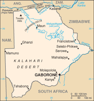
Botswana (GPS: 22 00 S, 24 00 E) is located in Southern Africa, north of South Africa. The country’s area measurements are total: 581,730 sq km; land: 566,730 sq km, water: 15,000 sq km. This sovereign state is slightly smaller than Texas. The total irrigated land is 20 sq km (2012).
One of the essential features of Botswana: Landlocked – enclosed or nearly enclosed by land. Population concentrated in the eastern part of the country.
It’s significant, and at the same time, the principal city, Gaborone’s GPS coordinates are 24 38 S 25 54 E. Gaborone’s local time is 7 hours ahead of Washington DC during Standard Time. The capital’s time difference: UTC+2.
Formerly the British protectorate of Bechuanaland, Botswana adopted its new name at independence in 1966. More than five decades of uninterrupted civilian leadership, progressive social policies, and significant capital investment have created one of Africa’s most stable economies. The ruling Botswana Democratic Party has won every election since independence; President Mokgweetsi Eric MASISI assumed the presidency in April 2018 following the retirement of former President Ian KHAMA due to constitutional term limits.
MASISI is Botswana’s fifth president since independence. Mineral extraction, principally diamond mining, dominates economic activity, though tourism is a growing sector due to its conservation practices and extensive nature preserves. Botswana has one of the world’s highest rates of HIV/AIDS infection but also one of Africa’s most progressive and comprehensive programs for dealing with the disease.
Botswana’s names conventional long form: the Republic of Botswana, traditional short form: Botswana, local long form: the Republic of Botswana, local short form: Botswana, former: Bechuanaland, etymology: the name Botswana means “Land of the Tswana” – referring to the country’s major ethnic group. Botswana’s name means “Land of the Tswana” – referring to the country’s major ethnic group.
Botswana’s terrain is typically predominantly flat to gently rolling tableland, the Kalahari Desert in the southwest. The country’s mean elevation: 1,013 m, elevation extremes; lowest point: junction of the Limpopo and Shashe Rivers 513 m, highest point: Tsodilo Hills 1,489 m.
The general climate in the country; semiarid: warm winters and hot summers.
The total number of border countries is 4, Namibia 1,544 km, South Africa 1,969 km, Zambia 0.15 km, Zimbabwe 834 km are the neighboring nations with the indicated border lengths. Botswana’s coastline is 0 km (landlocked country), while its marital claims are: none. Waterways: N/A. Land use: agricultural land: 45.8%; arable land 0.6%; permanent crops 0%; permanent pasture 45.2%; forest: 19.8%; other: 34.4% (2011 estimate).
The population in Botswana 2,249,104 (July 2018 estimate), urban population: 57.4% of total population (2015), major urban area’s population: GABORONE (capital) 247,000 (2014), while Botswana has N/A. Their spoken languages are: Setswana 77.3%, Sekalanga 7.4%, Shekgalagadi 3.4%, English (official language) 2.8%, Zezuru/Shona 2%, Sesarwa 1.7%, Sembukushu 1.6%, Ndebele 1%, other 2.8% (2011 estimate). Main religions in Botswana are Christian 79.1%, Badimo 4.1%, other 1.4% (includes Baha’i, Hindu, Muslim, Rastafarian), none 15.2%, unspecified 0.3% (2011 estimate). The nation uses (the) mixed legal system of civil law influenced by the Roman-Dutch model and customary and common law. It is a(n) parliamentary republic, National holiday(s) Independence Day (Botswana Day), 30 September (1966).
Economic overview for the country: Until the beginning of the global recession in 2008, Botswana maintained one of the world’s highest economic growth rates since its independence in 1966. Botswana recovered from the worldwide recession in 2010 but only grew modestly until 2017, primarily due to a global diamond market downturn. However, water and power shortages also played a role. Through fiscal discipline and sound management, Botswana has transformed itself from one of the world’s poorest countries five decades ago into a middle-income country with a per capita GDP of approximately $18,100 in 2017. Botswana also ranks as one of the least corrupt and best places to do business in sub-Saharan Africa. Because of its heavy reliance on diamond exports, Botswana’s economy closely follows global price trends for that one commodity. Diamond mining fueled much of Botswana’s past economic expansion and currently accounts for one-quarter of GDP, approximately 85% of export earnings, and about one-third of the government’s revenues.
In 2017, Diamond exports increased to the highest levels since 2013 at about 22 million carats of output, driving Botswana’s economic growth to about 4.5% and rising foreign exchange reserves to about 45% of GDP. De Beers, a major international diamond company, signed a 10-year deal with Botswana in 2012 and moved its rough stone sorting and trading division from London to Gaborone in 2013. The move was geared to support the development of Botswana’s nascent downstream diamond industry. Tourism is a secondary earner of foreign exchange, and many Batswana engage in tourism-related services, subsistence farming, and cattle rearing. According to official government statistics, unemployment is around 20%, but unofficial estimates run much higher. The prevalence of HIV/AIDS is the second highest globally and threatens its impressive economic gains.
Natural resources of Botswana: diamonds, copper, nickel, salt, soda ash, potash, coal, iron ore, silver.
Main export partners for Botswana, Africa are N/A for diamonds, copper, nickel, soda ash, meat, textiles, while the main import partners for the country are: N/A for foodstuffs, machinery, electrical goods, transport equipment, materials, fuel, and petroleum products, wood and paper products, metal and metal products.
When you visit this country in Africa, consider the natural hazards in Botswana: Periodic droughts, seasonal August winds blow from the west, carrying sand and dust across the country, which can obscure visibility, while infectious diseases are a degree of risk: high food or waterborne diseases: bacterial diarrhea, hepatitis A, and typhoid fever vectorborne disease: malaria (2016). Also, note that Botswana faces the following environmental issues: Overgrazing, Desertification, Limited freshwater resources, Air pollution.
You may also be interested in the countries next to Botswana around its total: 4,347.15 km border, like Namibia, South Africa, Zambia, Zimbabwe.