Zambia (GPS: 15 00 S, 30 00 E) is located in Southern Africa, east of Angola, south of the Democratic Republic of the Congo. The country’s area measurements are total: 752,618 sq km; land: 743,398 sq km, water: 9,220 sq km. This sovereign state is slightly larger than Texas. The total irrigated land is 1,560 sq km (2012).
One of the essential features of Zambia: Landlocked (enclosed or nearly enclosed by land). The Zambezi forms a natural riverine boundary with Zimbabwe. Lake Kariba on the Zambia-Zimbabwe border forms the world’s largest reservoir by volume (180 cu km. 43 cu mi).
It’s significant, and at the same time, the principal city, Lusaka’s GPS coordinates are 15 25 S 28 17 E. Lusaka’s local time is 7 hours ahead of Washington DC during Standard Time. The capital’s time difference: UTC+2.
For more information on Zambia, please scroll down below the Google Maps.
Google Maps Zambia and Lusaka, Africa
About Zambia in detail
Flag of Zambia
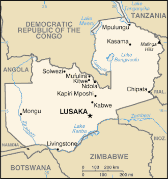
Map of Zambia
The former British South Africa Company administered the territory of Northern Rhodesia from 1891 until the UK took it in 1923. During the 1920s and 1930s, advances in mining spurred development and immigration. The name changed to Zambia upon independence in 1964. In the 1980s and 1990s, declining copper prices, economic mismanagement, and a prolonged drought hurt the economy. Elections in 1991 brought an end to one-party rule and propelled the Movement for Multiparty Democracy (MMD) to government. The subsequent vote in 1996, however, saw increasing harassment of opposition parties and abuse of state media and other resources
The election in 2001 was marked by administrative problems, with three parties filing a legal petition challenging the election of ruling party candidate Levy MWANAWASA. MWANAWASA was reelected in 2006 in an election that was deemed free and fair. Upon his death in August 2008, he was succeeded by his vice president, Rupiah BANDA, who won a special presidential byelection later that year. The MMD and BANDA lost to the Patriotic Front (PF) and Michael SATA in the 2011 general elections. However, SATA presided throughout haphazard economic management and attempted to silence opposition to PF policies. SATA died in October 2014 and was succeeded by his vice president, Guy SCOTT, who served as interim president until January 2015. Edgar LUNGU won the presidential byelection and completed SATA’s term. LUNGU then won a full term in the August 2016 presidential elections.
Zambia’s names conventional long form: the Republic of Zambia, conventional short form: Zambia, former: Northern Rhodesia, etymology: name derived from the Zambezi River, which flows through the western part of the country and forms its southern border with neighboring Zimbabwe. Name derived from the Zambezi River, which flows through the western part of the country and forms its southern border with neighboring Zimbabwe.
Zambia’s terrain is typically mostly high plateau with some hills and mountains. The country’s mean elevation: 1,138 m, elevation extremes; lowest point: Zambezi river 329 m, highest point: unnamed height in Mafinga Hills 2,301 m.
The general climate in the country; tropical: modified by altitude: rainy season (October to April).
The total number of border countries is 8, Angola 1,065 km, Botswana 0.15 km, the Democratic Republic of the Congo 2,332 km, Malawi 847 km, Mozambique 439 km, Namibia 244 km, Tanzania 353 km, Zimbabwe 763 km are the neighboring nations with the indicated border lengths. Zambia’s coastline is 0 km (landlocked country), while its marital claims are: none. Waterways: 2,250 km (includes Lake Tanganyika and the Zambezi and Luapula rivers) (2010). Land use: agricultural land: 31.7%; arable land 4.8%; permanent crops 0%; permanent pasture 26.9%; forest: 66.3%; other: 2% (2011 estimate).
The population in Zambia 16,445,079 (July 2018 estimate), urban population: 40.9% of total population (2015), major urban area’s population: LUSAKA (capital) 2.179 million (2015), while Zambia has N/A. Their spoken languages are: Bembe 33.4%, Nyanja 14.7%, Tonga 11.4%, Lozi 5.5%, Chewa 4.5%, Nsenga 2.9%, Tumbuka 2.5%, Lunda (North Western) 1.9%, Kaonde 1.8%, Lala 1.8%, Lamba 1.8%, English (official language) 1.7%, Luvale 1.5%, Mambwe 1.3%, Namwanga 1.2%, Lenje 1.1%, Bisa 1%, other 9.7%, unspecified 0.2%. Note: Zambia is said to have over 70 languages, although many of these may be considered dialects; all of Zambia’s major languages are members of the Bantu family (2010 estimate). The main religions in Zambia are Protestant, 75.3%, Roman Catholic 20.2%, other 2.7% (includes Muslim Buddhist, Hindu, and Baha’i), none 1.8% (2010 estimate).
The nation uses mixed legal system of English common law and customary law. It is a(n) presidential republic, National holiday(s) Independence Day, 24 October (1964).
Economic overview for the country: Zambia had one of the world’s fastest-growing economies for the ten years up to 2014, with real GDP growth averaging roughly 6.7% per annum, though growth slowed during the period 2015 to 2017, due to falling copper prices, reduced power generation, and depreciation of the kwacha. Zambia’s lack of economic diversification and dependency on copper as its sole major export makes it vulnerable to fluctuations in the world commodities market, and prices turned downward in 2015 due to declining demand from China; the Democratic Republic of Congo overtook Zambia as Africa’s largest copper producer.
GDP growth picked up in 2017 as mineral prices rose. Despite recent strong economic growth and its status as a lower-middle-income country, widespread and extreme rural poverty and high unemployment levels remain significant problems, made worse by a high birth rate, a relatively high HIV/AIDS burden, market-distorting agricultural and energy policies, and growing government debt. Zambia raised $7 billion from international investors by issuing separate sovereign bonds in 2012, 2014, and 2015. Concurrently, it issued over $4 billion in domestic debt and agreed to Chinese-financed infrastructure projects, significantly increasing its public debt burden to more than 60% of GDP. The government has considered refinancing $3 billion worth of Eurobonds and significant Chinese loans to cut debt servicing costs.
Main export partners for Zambia, Africa are China 25.5%, the Democratic Republic of the Congo 13%, South Africa 6.4%, South Korea 4.9%, India 4.3% (2015) for copper/cobalt, cobalt, electricity; tobacco, flowers, cotton, while the main import partners for the country are: South Africa 34.5%, the Democratic Republic of the Congo 18.2%, Kenya 9.7%, China 7.3%, India 4.4% (2015) for machinery, transportation equipment, petroleum products, electricity, fertilizer, foodstuffs, clothing.
When you visit this country in Africa, consider the natural hazards in Zambia: Periodic drought, tropical storms (November to April), while infectious diseases are a degree of risk: very high food or waterborne diseases: bacterial and protozoal diarrhea, hepatitis A, and typhoid fever vectorborne diseases: malaria and dengue fever water contact disease: schistosomiasis animal contact disease: rabies (2016). Also, note that Zambia faces the following environmental issues: Air pollution and resulting acid rain in the mineral extraction and refining region, Chemical runoff into watersheds, Loss of biodiversity, Poaching seriously threatens rhinoceros, elephant, antelope, and large cat populations, Deforestation, Soil erosion, Desertification, Lack of adequate water treatment presents human health risks.
You may also be interested in the countries next to Zambia around its total: 6,043.15 km border, like Angola, Botswana, the Democratic Republic of the Congo, Malawi, Mozambique, Namibia, Tanzania, Zimbabwe.