Tonga (GPS: 20 00 S, 175 00 W) is located in Oceania, an archipelago in the South Pacific Ocean, about two-thirds of the way from Hawaii to New Zealand. The country’s area measurements are total: 747 sq km; land: 717 sq km, water: 30 sq km. This sovereign state is four times the size of Washington, DC. The total irrigated land is 0 sq km (2012).
One of the crucial features of Tonga: The western islands (making up the Tongan Volcanic Arch) are all of volcanic origin. The eastern islands are nonvolcanic and are composed of coral limestone and sand.
It’s significant, and at the same time, the principal city, Nuku’alofa’s GPS coordinates are 21 08 S 175 12 W. Nuku’alofa’s local time is 18 hours ahead of Washington DC during Standard Time. The capital’s time difference: UTC+13.
For more information on Tonga, please scroll down below the Google Maps.
Google Maps Tonga and Nuku’alofa, Oceania
About Tonga in detail
Flag of Tonga
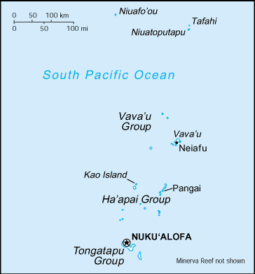
Map of Tonga
Tonga – unique among Pacific nations – never completely lost its indigenous governance. The archipelagos of “The Friendly Islands” were united into a Polynesian kingdom in 1845. Tonga became a constitutional monarchy in 1875 and a British protectorate in 1900; It withdrew from the protectorate and joined the Commonwealth of Nations in 1970. Tonga remains the only monarchy in the Pacific; In 2008, King George TUPOU V announced he was relinquishing most of his powers leading up to parliamentary elections in 2010. TUPOU died in 2012 and was succeeded by his brother ‘Aho’eitu TUPOU VI. Tropical Cyclone Gita, the strongest-ever recorded storm to impact Tonga, hit the islands in February 2018, causing extensive damage.
Tonga’s names conventional long form: the Kingdom of Tonga, traditional short form: Tonga, local extended state: Pule’anga Tonga, local short form: Tonga, former: Friendly Islands, etymology: “tonga” means “south” in the Tongan language and refers to the country’s geographic position about central Polynesia. “Tonga” means “south” in the Tongan language and refers to the country’s geographic position about central Polynesia.
Tonga’s terrain is typically mostly flat islands with limestone bedrock formed from the uplifted coral formation; others have limestone overlying volcanic rock. The country’s mean elevation: N/A, elevation extremes; lowest point: Pacific Ocean 0 m, highest point: the unnamed peak on Kao Island 1,033 m.
The country’s general climate is tropical: modified by trade winds: warm season (December to May), cool season (May to December).
The total number of border countries is 0; none are the neighboring nations with the indicated border lengths. Tonga’s coastline is 419 km, while its marital claims are: territorial sea: 12 nautical miles, exclusive economic zone: 200 nautical miles, continental shelf: 200-m depth or to the depth of exploitation. Waterways: N/A. Land use: agricultural land: 43.1%; arable land 22.2%; permanent crops 15.3%; permanent pasture 5.6%; forest: 12.5%; other: 44.4% (2011 estimate).
The population in Tonga 106,398 (July 2018 estimate), urban population: 23.7% of total population (2015), major urban area’s population: NUKU’ALOFA 25,000 (2014), while Tonga has N/A. Their spoken languages are: English and Tongan 87%, Tongan (official language) 10.7%, English (official language) 1.2%, other 1.1%, unspecified 0.03% (2006 estimate). Main religions in Tonga are Protestant 64.9% (includes Free Wesleyan Church 37.3%, Free Church of Tonga 11.4%, Church of Tonga 7.2%, Tokaikolo Christian Church 2.6%, Assembly of God 2.3%, Seventh Day Adventist 2.2%, Constitutional Church of Tonga 0.9%, Anglican 0.8% and Full Gospel Church 0.2%), Mormon 16.8%, Roman Catholic 15.6%, other 1.1%, none 0.03%, unspecified 1.7% (2006 estimate). The nation uses English common law. It is a(n) constitutional monarchy, National holiday(s) King’s Official Birthday, 4 July (1959); Constitution Day (National Day), 4 November (1875).
Economic overview for the country: Tonga has a small, open island economy and is the last constitutional monarchy among the Pacific Island countries. It has a narrow export base in agricultural goods. Squash, vanilla beans, and yams are the main crops. Agricultural exports, including fish, make up two-thirds of total exports. Tourism is the second-largest source of hard currency earnings following remittances. Tonga had 53,800 visitors in 2015.
The country must import a high proportion of its food, mainly from New Zealand. The country remains dependent on external aid and remittances from overseas Tongans to offset its trade deficit. The government emphasizes the development of the private sector, encouraging investment, and is committing increased funds for health care and education. Tonga’s English-speaking and educated workforce offers a viable labor market, and the tropical climate provides fertile soil. Renewable energy and deep-sea mining also provide investment opportunities. Tonga has a reasonably sound necessary infrastructure and well developed social services. But the government faces high unemployment among the young, moderate inflation, pressures for democratic reform, and rising civil service expenditures.
Natural resources of Tonga: fish, arable land.
Main export partners for Tonga, Oceania are Japan 16%, US 15.4%, Fiji 12.8%, NZ 12.5%, South Korea 11%, Samoa 10.7%, Australia 7.5%, American Samoa 6.8% (2015) for squash, fish, vanilla beans, root crops, while the main import partners for the country are: Fiji 37.7%, NZ 21.2%, China 14.2%, US 6.4%, Australia 4.5% (2015) for foodstuffs, machinery and transport equipment, fuels, chemicals.
When you visit this country in Oceania, consider the natural hazards in Tonga: Cyclones (October to April), earthquakes and volcanic activity on Fonuafo’ouvolcanism: moderate volcanic activity, Fonualei (elevation 180 m) has shown frequent activity in recent years, while Niuafo’ou (height 260 m), which last erupted in 1985, has forced evacuations, other historically active volcanoes include Late and Tofua, while infectious diseases are noted: active local transmission of Zika virus by Aedes species mosquitoes has been identified in this country (as of August 2016); it poses a significant risk (a large number of cases possible) among US citizens if bitten by an infective mosquito; other less common ways to get Zika are through sex, via blood transfusion, or during pregnancy, in which the pregnant woman passes Zika virus to her fetus (2016). Also, note that Tonga faces the following environmental issues: Deforestation from land being cleared for agriculture and settlement, Soil exhaustion, water pollution due to salinization, sewage, and toxic chemicals from farming activities, Coral reefs, and marine populations threatened.
You may also be interested in the countries next to Tonga around its 0 km border – No border countries.