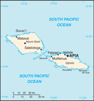
Samoa (GPS: 13 35 S, 172 20 W) is located in Oceania, a group of islands in the South Pacific Ocean, about halfway between Hawaii and New Zealand. The country’s area measurements are total: 2,831 sq km; land: 2,821 sq km, water: 10 sq km. This sovereign state is slightly smaller than Rhode Island. The total irrigated land is 0 sq km (2012).
One of the critical features of Samoa: Occupies an almost central position within Polynesia.
It’s significant, and at the same time, the principal city, Apia’s GPS coordinates are 13 49 S 171 46 W. Apia’s local time is 18 hours ahead of Washington DC during Standard Time. The capital’s time difference: UTC+13, note; +1hr begins last Sunday in September; ends first Sunday in April.
For more information on Samoa, please scroll down below the Google Maps.
Google Maps Samoa and Apia, Oceania
About Samoa in detail
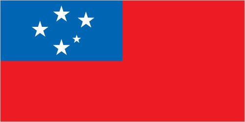
Flag of Samoa
Map of Samoa
New Zealand occupied the German protectorate of Western Samoa at the outbreak of World War I in 1914. It continued to administer the islands as a mandate and then as a trust territory until 1962 when the islands became the first Polynesian nation to reestablish independence in the 20th century. The country dropped the “Western” from its name in 1997.
In the late 2000s, Samoa began making efforts to align more closely with Australia and New Zealand. In 2009, Samoa changed its driving orientation to the road’s left side, in line with other Commonwealth countries. In 2011, Samoa jumped forward one day – skipping December 30 – by moving to the west of the International Date Line so that it was one hour ahead of New Zealand and three hours ahead of Australia’s east coast, rather than 23 and 21 hours behind, respectively.
Samoa’s names conventional long form: Independent State of Samoa, traditional short form: Samoa, local long form: Malo Sa’oloto Tuto’atasi o Samoa, local short form: Samoa, former: Western Samoa. Note: the name “Samoa” is composed of two parts, “sa” meaning sacred and “moa” meaning center, so that the term can mean Holy Center; alternatively, it can mean “place of the sacred moa bird” of Polynesian mythology.
Samoa’s terrain is typically two main islands (Savaii, Upolu) and several smaller islands and uninhabited islets; narrow coastal plain with volcanic, rugged mountains. The country’s mean elevation: N/A, elevation extremes; lowest point: Pacific Ocean 0 m, highest point: Mount Silisili 1,857 m.
The country’s general climate is tropical: rainy season (November to April), dry season (May to October).
The total number of border countries is 0; none are the neighboring nations with the indicated border lengths. Samoa’s coastline is 403 km, while its marital claims are: territorial sea: 12 nautical miles, contiguous zone: 24 nautical miles, exclusive economic zone: 200 nautical miles. Waterways: N/A. Land use: agricultural land: 12.4%; arable land 2.8%; permanent crops 7.8%; permanent pasture 1.8%; forest: 60.4%; other: 27.2% (2011 estimate).
The population in Samoa 201,316 (July 2018 estimate), urban population: 19.1% of total population (2015), major urban area’s population: APIA (capital) 37,000 (2014), while Samoa has N/A. Their spoken languages are Samoan (Polynesian) (official language), English. Main religions in Samoa are Protestant 57.4% (Congregationalist 31.8%, Methodist 13.7%, Assembly of God 8%, Seventh-Day Adventist 3.9%), Roman Catholic 19.4%, Mormon 15.2%, Worship Centre 1.7%, other Christian 5.5%, other 0.7%, none 0.1%, unspecified 0.1% (2011 estimate). The nation uses a mixed legal system of English common law and customary law; judicial review of legislative acts concerning citizens’ fundamental rights. It is a(n) parliamentary republic, National holiday(s) Independence Day Celebration, 1 June (1962).
Economic overview for the country: The economy of Samoa has traditionally been dependent on development aid, family remittances from overseas, tourism, agriculture, and fishing. It has a nominal GDP of $844 million. Agriculture, including fishing, furnishes 90% of exports, featuring fish, coconut oil, nonu products, and taro. The manufacturing sector mainly processes agricultural products. Industry accounts for nearly 22% of GDP while employing less than 6% of the workforce. The service sector accounts for almost two-thirds of GDP and uses approximately 50% of the labor force. Tourism is an expanding sector accounting for 25% of GDP; 132,000 tourists visited the islands in 2013. The country is vulnerable to devastating storms.
In September 2009, an earthquake and the resulting tsunami severely damaged Samoa and nearby American Samoa, disrupting transportation and power generation and about 200 deaths. In December 2012, extensive flooding and wind damage from Tropical Cyclone Evan killed four people, displaced over 6,000, and damaged or destroyed an estimated 1,500 homes on Samoa’s Upolu Island. The Samoan Government has called for deregulation of the country’s financial sector, encouragement of investment, and continued fiscal discipline, while at the same time protecting the environment. Foreign reserves are relatively healthy, and inflation is low, but external debt is approximately 45% of GDP. Samoa became the 155th member of the WTO in May 2012 and graduated from least developed country status in January 2014.
Natural resources of Samoa: hardwood forests, fish, hydropower.
Main export partners for Samoa, Oceania are American Samoa 57.1%, Australia 17.2% (2015) for fish, coconut oil and cream, nonu, copra, taro, automotive parts, garments, beer, while the main import partners for the country are: Fiji 22.6%, NZ 18.8%, China 15.8%, South Korea 7.9%, Australia 6%, US 5.6%, Singapore 5.2% (2015) for machinery and equipment, industrial supplies, foodstuffs.
When you visit this country in Oceania, consider the natural hazards in Samoa: Occasional typhoons, active volcanism. Volcanism: Savai’i Island (elevation 1,858 m), which last erupted in 1911, is historically active, while infectious diseases are noted: active local transmission of Zika virus by Aedes species mosquitoes has been identified in this country (as of August 2016); it poses a critical risk (a large number of cases possible) among US citizens if bitten by an infective mosquito; other less common ways to get Zika are through sex, via blood transfusion, or during pregnancy, in which the pregnant woman passes Zika virus to her fetus (2016). Also, note that Samoa faces the following environmental issues: Soil erosion, deforestation, invasive species, overfishing.
You may also be interested in the countries next to Samoa around its 0 km border – No border countries.