Fiji (GPS: 18 00 S, 175 00 E) is located in Oceania, an island group in the South Pacific Ocean, about two-thirds of the way from Hawaii to New Zealand. The country’s area measurements are total: 18,274 sq km; land: 18,274 sq km, water: 0 sq km. This sovereign state is slightly smaller than New Jersey. The total irrigated land is 40 sq km (2012).
One of the important features of Fiji: Includes 332 islands. Approximately 110 are inhabited.
It’s significant, and at the same time, the principal city, Suva’s GPS coordinates are 18 08 S 178 25 E. Suva’s local time is 17 hours ahead of Washington DC during Standard Time. The capital’s time difference: UTC+12, note; Daylight saving time: +1hr begins fourth Sunday in October; ends third Sunday in January.
For more information on Fiji, please scroll down below the Google Maps.
Google Maps Fiji and Suva, Oceania
About Fiji in detail
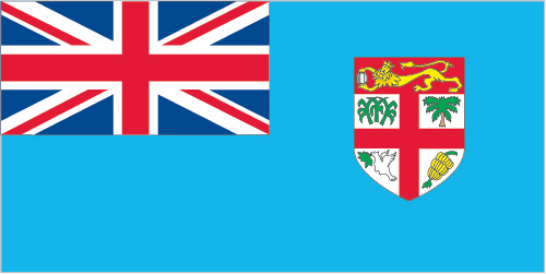
Flag of Fiji
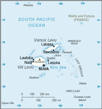
Map of Fiji
Fiji became independent in 1970 after nearly a century as a British colony. Democratic rule was interrupted by two military coups in 1987 caused by concern over a government perceived as dominated by the Indian community (descendants of contract laborers brought to the British islands in the 19th century). The coups and a 1990 constitution that cemented native Melanesian control of Fiji led to heavy Indian emigration; The population loss resulted in economic difficulties but ensured that Melanesians became the majority. A new constitution enacted in 1997 was more equitable. Free and peaceful elections in 1999 resulted in a government led by an Indo-Fijian, but a civilian-led coup in 2000 ushered in a prolonged period of political turmoil.
Parliamentary elections held in 2001 provided Fiji with a democratically elected government led by Prime Minister Laisenia QARASE. Reelected in May 2006, QARASE was ousted in a December 2006 military coup led by Commodore Voreqe BAINIMARAMA, who initially appointed himself acting president but in January 2007 became interim prime minister. Following years of political turmoil, long-delayed legislative elections were held in September 2014 that were deemed “credible” by international observers, resulting in BAINIMARAMA being reelected. He was reelected in November 2018 in elections deemed free and fair.
Fiji’s names conventional long form: the Republic of Fiji, traditional short form: Fiji, local long form: Republic of Fiji/Matanitu ko Viti, local short form: Fiji/Viti, etymology: the Fijians called their home Viti, but the neighboring Tongans called it Fisi, and in the Anglicized spelling of the Tongan pronunciation – promulgated by explorer Captain James COOK – the designation became Fiji.
Fiji’s terrain is typically mostly mountains of volcanic origin. The country’s mean elevation: N/A, elevation extremes; lowest point: Pacific Ocean 0 m, highest point: Tomanivi 1,324 m.
The general climate in the country; tropical marine: only slight seasonal temperature variation.
The total number of border countries is 0; none are the neighboring nations with the indicated border lengths. Fiji’s coastline is 1,129 km. Its marital claims are: measured from claimed archipelagic straight baselines territorial sea: 12 nautical miles, exclusive economic zone: 200 nautical miles, continental shelf: 200-m depth or to the depth of exploitation; rectilinear shelf claim added. Waterways: 203 km (122 km are navigable by motorized craft and 200-metric-ton barges) (2012). Land use: agricultural land: 23.3%; arable land 9%; permanent crops 4.7%; permanent pasture 9.6%; forest: 55.7%; other: 21% (2011 estimate).
The population in Fiji 926,276 (July 2018 estimate), urban population: 53.7% of total population (2015), major urban area’s population: SUVA (capital) 176,000 (2014), while Fiji has N/A. Their spoken languages are English (official language), Fijian (official language), Hindustani. Main religions in Fiji are Protestant 45% (Methodist 34.6%, Assembly of God 5.7%, Seventh Day Adventist 3.9%, and Anglican 0.8%), Hindu 27.9%, other Christian 10.4%, Roman Catholic 9.1%, Muslim 6.3%, Sikh 0.3%, other 0.3%, none 0.8% (2007 estimate). The nation uses a common law system based on the English model. It is a(n) parliamentary republic, National holiday(s) Constitution Day, 7 September; Fiji (independence) Day, 10 October (1970).
Economic overview for the country: Fiji, endowed with forest, mineral, and fish resources, is one of the most developed and connected Pacific island economies. With an estimated 842,884 tourists visiting in 2017, earnings from the tourism industry and remittances from Fijian’s working abroad are the country’s largest foreign exchange-earners. Bottled water exports to the US is Fiji’s most extensive domestic export. Fiji’s sugar sector remains a significant industry and a major export, but crops and one of the sugar mills suffered damage during Cyclone Winston in 2016. Fiji’s trade imbalance continues to widen with increased imports and sluggish performance of domestic exports. The return to parliamentary democracy and successful elections in September 2014 improved investor confidence. Still, increasing bureaucratic regulation, new taxes, and lack of consultation with relevant stakeholders brought four consecutive years of decline for Fiji on the World Bank Ease of Doing Business index. Private sector investment in 2017 approached 20% of GDP, compared to 13% in 2013.
Main export partners for Fiji, Oceania are US 13.4%, Australia 10.2%, Samoa 6.7%, Tonga 5.9% (2015) for sugar, garments, gold, timber, fish, molasses, coconut oil, mineral water, while the main import partners for the country are: China 16.2%, South Korea 15.7%, NZ 14%, Australia 13.4%, Singapore 8.7%, France 7% (2015) for manufactured goods, machinery and transport equipment, petroleum products, food, chemicals.
When you visit this country in Oceania, consider the natural hazards in Fiji: Cyclonic storms can occur from November to January, while infectious diseases are noted: active local transmission of Zika virus by Aedes species mosquitoes has been identified in this country (as of August 2016); it poses a significant risk (a large number of cases possible) among US citizens if bitten by an infective mosquito; other less common ways to get Zika are through sex, via blood transfusion, or during pregnancy, in which the pregnant woman passes Zika virus to her fetus (2016). Also, note that Fiji faces the following environmental issues: The widespread practice of waste incineration is a significant contributor to air pollution. Vehicle emissions in urban areas, Deforestation, and soil erosion are significant problems. A contributory factor to erosion is clearing land by bush burning, a widespread practice that threatens biodiversity.
You may also be interested in Fiji’s surrounding countries around its 0 km border – No border countries.