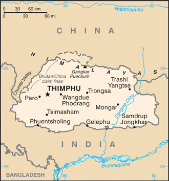
Bhutan (GPS: 27 30 N, 90 30 E) is located in Southern Asia, between China and India. The country’s area measurements are total: 38,394 sq km; land: 38,394 sq km, water: 0 sq km. This sovereign state is about one-half the size of Indiana. The total irrigated land is 320 sq km (2012).
One of the essential features of Bhutan: Landlocked (enclosed or nearly enclosed by land). Strategic location between China and India. Controls several critical Himalayan mountain passes.
It’s significant, and simultaneously, the principal city, Thimphu’s GPS coordinates are 27 28 N 89 38 E. Thimphu’s local time is 11 hours ahead of Washington DC during Standard Time. The capital’s time difference: UTC+6.
For more information on Bhutan, please scroll down below the Google Maps.
Google Maps Bhutan and Thimphu, Asia
About Bhutan in detail
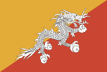
Flag of Bhutan
Map of Bhutan
Following Britain’s victory in the 1865 Duar War, Britain and Bhutan signed the Treaty of Sinchulu. Bhutan would receive an annual subsidy in exchange for ceding land to British India. Ugyen WANGCHUCK – who had served as the de facto ruler of an increasingly unified Bhutan and had improved relations with the British toward the end of the 19th century – was named king in 1907. Three years later, a treaty was signed whereby the British agreed not to interfere in Bhutanese internal affairs, and Bhutan allowed Britain to direct its foreign affairs. Bhutan negotiated a similar arrangement with independent India in 1949. The Indo-Bhutanese Treaty of Friendship returned to Bhutan a small piece of the territory annexed by the British, formalized the country’s annual subsidies, and defined India’s responsibilities in defense and foreign relations. Under a succession of modernizing monarchs beginning in the 1950s, Bhutan joined the UN in 1971 and slowly continued its engagement beyond its borders. In 2005, King Jigme Singye WANGCHUCK unveiled the draft of Bhutan’s first constitution – which introduced major democratic reforms – and held a national referendum for its approval.
The King abdicated the throne in 2006 in favor of his son, Jigme Khesar Namgyel WANGCHUCK. In 2007, India and Bhutan renegotiated their treaty, eliminating the clause that stated that Bhutan would be “guided by” India in conducting its foreign policy. However, Thimphu continues to coordinate closely with New Delhi. In 2008, Bhutan held its first parliamentary election by the constitution. Bhutan experienced a peaceful turnover of power following a parliamentary election in 2013, which resulted in the incumbent party’s defeat. In 2018, the incumbent party again lost the parliamentary election. Of the more than 100,000 ethnic Nepali – predominantly Lhotshampa – refugees who fled or were forced out of Bhutan in the 1990s, about 6,500 remain displaced in Nepal.
Bhutan’s names conventional long form: the Kingdom of Bhutan, conventional short form: Bhutan, local long form: Druk Gyalkhap, local short form: Druk Yul, etymology: named after the Bhotia, the ethnic Tibetans who migrated from Tibet to Bhutan; Bod is the Tibetan name for their land; the Bhutanese name “Druk Yul” means “Land of the Thunder Dragon.”
Bhutan’s terrain is typically mostly mountainous, with some fertile valleys and savanna. The country’s mean elevation: 2,220 m, elevation extremes; lowest point: Drangeme Chhu 97 m, highest point: Gangkar Puensum 7,570 m.
The general climate in the country; varies: tropical in southern plains: cool winters and hot summers in central valleys: severe winters and cool summers in the Himalayas.
The total number of border countries is 2, China 477 km, India 659 km are the neighboring nations with the indicated border lengths. Bhutan’s coastline is 0 km (landlocked country), while its marital claims are: none. Waterways: N/A. Land use: agricultural land: 13.6%; arable land 2.6%; permanent crops 0.3%; permanent pasture 10.7%; forest: 85.5%; other: 0.9% (2011 estimate).
The population in Bhutan 766,397 (July 2018 estimate), urban population: 38.6% of total population (2015), major urban area’s population: THIMPHU (capital) 152,000 (2014), while Bhutan has N/A. Their spoken languages are: Sharchhopka 28%, Dzongkha (official language) 24%, Lhotshamkha 22%, other 26% (includes foreign languages) (2005 estimate). Bhutan’s main religions are Lamaistic Buddhist 75.3%, Indian- and Nepalese-influenced Hinduism 22.1%, other 2.6% (2005 estimate). The nation uses civil law based on Buddhist religious law. It is a(n) constitutional monarchy, National holiday(s) National Day (Ugyen WANGCHUCK became first hereditary king), 17 December (1907).
Economic overview for the country: Bhutan’s small economy is based mainly on hydropower, agriculture, and forestry, which provide the main livelihood for more than half the population. Because rugged mountains dominate the terrain and make roads and other infrastructure difficult and expensive, industrial production is primarily of the cottage industry type. The economy is closely aligned with India’s through strong trade and monetary links. It is dependent on India for financial assistance and migrant laborers for development projects, especially for road construction. Bhutan signed a pact in December 2014 to expand duty-free trade with Bangladesh. Multilateral development organizations administer most educational, social, and environmental programs and consider the government’s desire to protect the country’s environment and cultural traditions. For example, the government is cautious in expanding the tourist sector, restricting visits to environmentally conscientious tourists. Complicated controls and uncertain policies in industrial licensing, trade, labor, and finance continue to hamper foreign investment.
Bhutan’s largest export – hydropower to India – could spur sustainable growth in the coming years if Bhutan resolves chronic delays in construction. Bhutan’s hydropower exports comprise 40% of total exports and 25% of the government’s total revenue. Bhutan currently taps only 6.5% of its 24,000-megawatt hydropower potential. It is behind schedule in building 12 new hydropower dams with a combined capacity of 10,000 megawatts by 2020 by a deal signed in 2008 with India. The high volume of imported materials to build hydropower plants has expanded Bhutan’s trade and current account deficits. Bhutan also signed a memorandum of understanding with Bangladesh and India in July 2017 to construct a new hydropower plant to export electricity to Bangladesh.
Natural resources of Bhutan: timber, hydropower, gypsum, calcium carbonate.
Main export partners for Bhutan, Asia are India 83.8%, Hong Kong 10.8% (2013 estimate) for electricity (to India), ferrosilicon, cement, calcium carbide, copper wire, manganese, vegetable oil, while the main import partners for the country are: India 72.3%, South Korea 6% (2013 estimate) for fuel and lubricants, passenger cars, machinery and parts, fabrics, rice.
When you visit this country in Asia, consider the natural hazards in Bhutan: Violent storms from the Himalayas are the source of the country’s Bhutanese name, which translates as Land of the Thunder Dragon, frequent landslides during the rainy season, while infectious diseases are the degree of risk: high food or waterborne diseases: bacterial and protozoal diarrhea, hepatitis A, and typhoid fever vectorborne diseases: dengue fever (2016). Also, note that Bhutan faces the following environmental issues: Soil erosion, Limited access to potable water, wildlife conservation, Industrial pollution, waste disposal.
You may also be interested in Bhutan’s surrounding countries around its total 1,136 km border, like China, India.