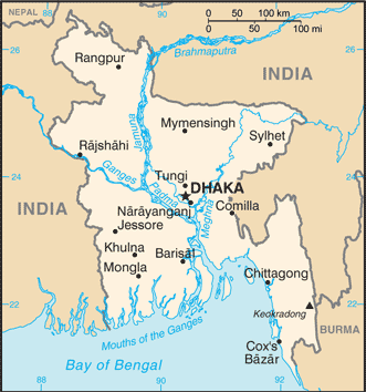
Bangladesh (GPS: 24 00 N, 90 00 E) is located in Southern Asia, bordering the Bay of Bengal, between Burma and India. The country’s area measurements are total: 148,460 sq km; land: 130,170 sq km, water: 18,290 sq km. This sovereign state is slightly smaller than Iowa’s. The total irrigated land is 53,000 sq km (2012).
One of Bangladesh’s essential features is that most of the country situated on deltas of large rivers flowing from the Himalayas: the Ganges unites with the Jamuna (main channel of the Brahmaputra) later joins the Meghna to empty into the Bay of Bengal, eventually.
It’s significant, and simultaneously, the principal city, Dhaka’s GPS coordinates are 23 43 N 90 24 E. Dhaka’s local time is 11 hours ahead of Washington DC during Standard Time. The capital’s time difference: UTC+6.
The huge delta region formed at the confluence of the Ganges and Brahmaputra River systems – now referred to as Bangladesh – was a loosely incorporated outpost of various empires centered on the Gangetic plain for much of the first millennium A.D. Muslim conversions and settlement in the region began in the 10th century, primarily from Arab and Persian traders and preachers. Europeans established trading posts in the area in the 16th century.
Eventually, the area known as Bengal, primarily Hindu in the western section and mostly Muslim in the eastern half, became part of British India. In 1947 resulted in an east wing of Pakistan in the Muslim-majority area, which became East Pakistan. Calls for greater autonomy and animosity between Pakistan’s eastern and western branches led to a Bengali independence movement. That movement, led by the Awami League (AL) and supported by India, won Bangladesh’s independence war in 1971. The post-independence AL government faced daunting challenges, and in 1975 it was overthrown by the military, triggering a series of military coups that resulted in a military-backed government and subsequent creation of the Bangladesh Nationalist Party (BNP) in 1978. That government also ended in a coup in 1981, followed by military-backed rule until democratic elections occurred in 1991. The BNP and AL have alternated in power since 1991, except for a military-backed emergency caretaker regime that suspended parliamentary elections planned for January 2007 to reform the political system and root out corruption. That government returned the country to fully democratic rule in December 2008 with the election of the AL and Prime Minister Sheikh HASINA.
In January 2014, the incumbent AL won the national election by an overwhelming majority after the BNP boycotted the election, which extended HASINA’s term as prime minister. In December 2018, HASINA secured a third consecutive term (fourth overall) with the AL coalition securing 96% of available seats, amid widespread election irregularities. With the help of international development assistance, Bangladesh has reduced the poverty rate from over half of the population to less than a third, achieved Millennium Development Goals for maternal and child health, and made significant food security progress since independence. The economy has grown at an annual average of about 6% for the last two decades, and the country reached World Bank’s lower-middle-income status in 2014.
Bangladesh’s names conventional long form: The people’s republic of Bangladesh, traditional short form: Bangladesh, local long form: Gana Prajatantri Bangladesh, local short form: Bangladesh, former: East Bengal, East Pakistan, etymology: the name – a compound of the Bengali words “Bangla” (Bengal) and “desh” (country) – means “Country of Bengal.” The name – a compound of the Bengali words “Bangla” (Bengal) and “desh” (country) – means “Country of Bengal.”
Bangladesh’s terrain is typically mostly flat alluvial plain; hilly in southeast. The country’s mean elevation: 85 m, elevation extremes; lowest point: Indian Ocean 0 m, highest point: Keokradong 1,230 m.
The general climate in the country; tropical: mild winter (October to March): hot, humid summer (March to June): moist, warm rainy monsoon (June to October).
The total number of border countries is 2, Burma 271 km, India 4,142 km are the neighboring nations with the indicated border lengths. Bangladesh’s coastline is 580 km. Its marital claims are territorial sea: 12 nautical miles, contiguous zone: 18 nautical miles, exclusive economic zone: 200 nautical miles, continental shelf: to the outer limits of the continental margin. Waterways: 8,370 km (includes up to 3,060 km of main cargo routes; network reduced to 5,200 km in the dry season) (2011). Land use: agricultural land: 70.1%; arable land 59%; permanent crops 6.5%; permanent pasture 4.6%; forest: 11.1%; other: 18.8% (2011 estimate).
The population in Bangladesh 159,453,001 (July 2018 estimate), urban population: 34.3% of total population (2015), major urban area’s population: DHAKA (capital) 17.598 million; Chittagong 4.539 million; Khulna 1.022 million; Rajshahi 844,000 (2015), while Bangladesh has N/A. Their spoken languages are Bangla 98.8% (official language, also known as Bengali), other 1.2% (2011 estimate). Main religions in Bangladesh are Muslim 89.1%, Hindu 10%, other 0.9% (includes Buddhist, Christian) (2013 estimate). The nation uses mixed legal system of mostly English common law and Islamic law. It is a(n) parliamentary republic, National holiday(s) Independence Day, 26 March (1971); Victory Day, 16 December (1971), memorializes the military victory over Pakistan and the official creation of the state of Bangladesh.
Economic overview for the country: Bangladesh’s economy has grown roughly 6% per year since 2005 despite prolonged political instability, poor infrastructure, endemic corruption, insufficient power supplies, and slow implementation of economic reforms. Although more than half of GDP is generated through the services sector, almost half of Bangladeshis are employed in the agriculture sector, with rice as the single-most-important product.
Garments, the backbone of Bangladesh’s industrial sector, accounted for more than 80% of total exports in FY 2016-2017. The industrial sector continues to grow, despite the need for improvements in factory safety conditions. Steady export growth in the garment sector, combined with $13 billion in remittances from overseas Bangladeshis, contributed to Bangladesh’s rising foreign exchange reserves in FY 2016-2017. Recent improvements to energy infrastructure, including the start of liquefied natural gas imports in 2018, represent a significant step in resolving a critical growth bottleneck.
Natural resources of Bangladesh: natural gas, arable land, timber, coal.
Main export partners for Bangladesh, Asia are the US 13.9%, Germany 12.9%, UK 8.9%, France 5%, Spain 4.7% (2015) for garments, knitwear, agricultural products, frozen food (fish and seafood), jute and jute goods, leather, while the main import partners for the country are: China 22.4%, India 14.1%, Singapore 5.2% (2015) for cotton, machinery, and equipment, chemicals, iron and steel, foodstuffs.
When you visit this country in Asia, consider the natural hazards in Bangladesh: Droughts and cyclones. Much of the country routinely inundated during the summer monsoon season, while infectious diseases are the degree of risk: high food or waterborne diseases: bacterial and protozoal diarrhea, hepatitis A and E, and typhoid fever vectorborne diseases: dengue fever and malaria are increased risks in some locations water contact disease: leptospirosis animal contact disease: rabies (2016). Also, note that Bangladesh faces the following environmental issues: Many people are landless and forced to live on and cultivate flood-prone land, waterborne diseases prevalent in surface water, water pollution, especially of fishing areas, results from the use of commercial pesticides, Groundwater contaminated by naturally occurring arsenic, Intermittent water shortages because of falling water tables in the northern and central parts of the country, Soil degradation, and erosion, Deforestation, Destruction of wetlands, Severe overpopulation with noise pollution.
You may also be interested in the countries next to Bangladesh around its total: 4,413 km border, like Burma, India.