Burma (GPS: 22 00 N, 98 00 E) is located in Southeastern Asia, bordering the Andaman Sea and the Bay of Bengal, between Bangladesh and Thailand. The country’s area measurements are total: 676,578 sq km; land: 653,508 sq km, water: 23,070 sq km. This sovereign state is slightly smaller than Texas. The total irrigated land is 22,950 sq km (2012).
One of the important features of Burma: Strategic location near major Indian Ocean shipping lanes. The north-south flowing Irrawaddy River is the country’s largest and most important commercial waterway.
It’s significant, and at the same time, the principal city, Rangoon’s GPS coordinates are 16 48 N 96 09 E. Rangoon’s local time is 11.5 hours ahead of Washington DC during Standard Time. The capital’s time difference: UTC+6.5.
For more information on Burma, please scroll down below the Google Maps.
Google Maps Burma and Rangoon, Southeast Asia
About Burma in detail
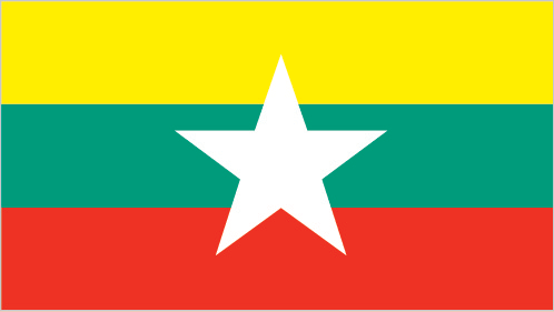
Flag of Burma
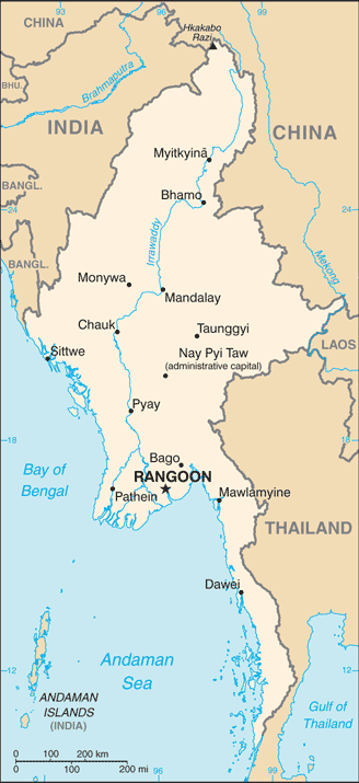
Map of Burma
Various ethnic Burman and ethnic minority city-states or kingdoms occupied the present borders through the 19th century. Several minority ethnic groups continue to maintain independent armies and control territory within the country today, in opposition to the central government. For 62 years (1824-1886), Britain conquered Burma and incorporated all the groups within the country into its Indian Empire. Burma was administered as a province of India until 1937, when it became a separate, self-governing colony; In 1948, following major battles on its territory during World War II, Burma attained independence from the British Commonwealth.
Gen. NE WIN dominated the government from 1962 to 1988, first as a military ruler, then as a self-appointed president, and later as political kingpin. In response to widespread civil unrest, NE WIN resigned in 1988, but the military crushed student-led protests within months and took power. Since independence, successive Burmese governments have fought on-and-off conflicts with armed ethnic groups seeking autonomy in their mountainous border regions. Multiparty legislative elections in 1990 resulted in the main opposition party – the National League for Democracy (NLD) – winning a landslide victory. Instead of handing over power, the junta placed NLD leader (and 1991 Nobel Peace Prize recipient) AUNG SAN SUU KYI under house arrest from 1989 to 1995, 2000 to 2002, and from May 2003 to November 2010.
In late September 2007, the junta brutally suppressed protests over increased fuel prices led by prodemocracy activists and Buddhist monks, killing an unknown number of people and arresting thousands for participating in the demonstrations – popularly referred to as the Saffron Revolution. In early May 2008, Cyclone Nargis struck Burma, which left over 138,000 dead and tens of thousands injured and homeless. Despite this tragedy, the junta proceeded with its May constitutional referendum, the first vote in Burma since 1990. The 2008 constitution reserves 25% of its seats to the military. In November 2010, legislative elections held which the NLD boycotted and many in the international community considered flawed saw the successor junta’s mass organization, the Union Solidarity and Development Party, garner over 75% the contested seats. The national legislature convened in January 2011 and selected former Prime Minister THEIN SEIN as president.
Although the vast majority of national-level appointees named by THEIN SEIN were former or current military officers, the government initiated a series of political and economic reforms leading to a substantial opening of the long-isolated country. These reforms included releasing hundreds of political prisoners, signing a nationwide cease-fire with several of the country’s ethnic armed groups, pursuing legal reform, and gradually reducing restrictions on freedom of the press, association, and civil society. Due in part to these reforms, AUNG SAN SUU KYI was elected to the national legislature in April 2012 and became chair of the Committee for Rule of Law and Tranquility. Burma served as chair of the Association of Southeast Asian Nations (ASEAN) for 2014. In a flawed but largely credible national legislative election in November 2015 featuring more than 90 political parties, the NLD again won a landslide victory. Using its overwhelming majority in both parliament houses, the NLD elected HTIN KYAW, AUNG SAN SUU KYI’s confidant and long-time NLD supporter, as president. The new legislature created the position of State Counsellor, according to AUNG SAN SUU KYI, a formal role in the government and making her the de facto head of state. After more than five decades of military dictatorship, Burma’s first credibly elected civilian government was sworn into office on 30 March 2016. In March 2018, upon HTIN KYAW’s resignation, parliament selected WIN MYINT, another long-time ally of AUNG SAN SUU KYI’s.
In October 2016 and August 2017, on security forces in northern Rakhine State by the Arakan Rohingya Salvation Army (ARSA), a Rohingya militant group, resulted in military crackdowns on the Rohingya population that reportedly caused thousands of deaths and human rights abuses. Following the August 2017 violence, over 740,000 Rohingya fled to neighboring Bangladesh as refugees. In November 2017, the US Department of State determined that the August 2017 violence constituted ethnic cleansing. The UN has called for Burma to allow access to a Fact-Finding Mission to investigate reports of human rights violations and abuses and work with Bangladesh to facilitate Rohingya refugees’ repatriation. In September 2018, the International Criminal Court (ICC) determined it had jurisdiction to investigate reported human rights abuses against Rohingyas.
Burma has rejected ethnic cleansing and genocide charges and has chosen not to work with the UN Fact-Finding Mission or the ICC. In March 2018, President HTIN KYAW announced his voluntary retirement; the parliament named NLD parliamentarian WIN MYINT. In February 2019, the NLD announced it would establish a parliamentary committee to examine options for constitutional reform ahead of national the elections planned for 2020.
Burma’s names conventional long form: Union of Burma, conventional short form: Burma, local long form: Pyidaungzu Thammada Myanma Naingngandaw (translated as the Republic of the Union of Myanmar), local short form: Myanma Naingngandaw, former: the Socialist Republic of the Union of Burma, Union of Myanmar. Note: since 1989, the military authorities in Burma and the current parliamentary government have promoted the name Myanmar as a conventional name for their state; the US Government has not adopted the name, etymology: both “Burma” and “Myanmar” derive from the name of the majority Burmese Bamar ethnic group. Both “Burma” and “Myanmar” derive from the name of the majority Burman (Bamar) ethnic group.
Burma’s terrain is typically central lowlands ringed by steep, rugged highlands. The country’s mean elevation: 702 m, elevation extremes; lowest point: Andaman Sea/Bay of Bengal 0 m, highest point: Gamlang Razi 5,870 m.
The country’s general climate is tropical monsoon: cloudy, rainy, hot, humid summers (southwest monsoon, June to September): less cloudy, scant rainfall, mild temperatures, lower humidity during winter (northeast monsoon, December to April).
The total number of border countries is 5, Bangladesh 271 km, China 2,129 km, India 1,468 km, Laos 238 km, Thailand 2,416 km are the neighboring nations with the indicated border lengths. Burma’s coastline is 1,930 km. Its marital claims are territorial sea: 12 nautical miles, contiguous zone: 24 nautical miles, exclusive economic zone: 200 nautical miles, continental shelf: 200 nautical miles or the edge of the continental margin. Waterways: 12,800 km (2011). Land use: agricultural land: 19.2%; arable land 16.5%; permanent crops 2.2%; permanent pasture 0.5%; forest: 48.2%; other: 32.6% (2011 estimate).
The population in Burma 55,622,506 (July 2018 estimate), urban population: 34.1% of total population (2015), major urban area’s population: RANGOON (Yangon) (capital) 4.802 million; Mandalay 1.167 million; Nay Pyi Taw 1.03 million (2015), while Burma has N/A. Their spoken languages are Burmese (official language). Note: minority ethnic groups have their languages. Main religions in Burma are Buddhist 87.9%, Christian 6.2%, Muslim 4.3%, Animist 0.8%, Hindu 0.5%, other 0.2%, none 0.1%note: religion estimate is based on the 2014 national census, including an estimate for the non-enumerated population of Rakhine State, which is assumed to mainly affiliate with the Islamic faith (2014 estimate). The nation uses mixed legal system of English common law (as introduced in codifications designed for colonial India) and customary law. It is a(n) parliamentary republic, National holiday(s) Independence Day, 4 January (1948); Union Day, 12 February (1947).
Economic overview for the country: Since Burma began the transition to a civilian-led government in 2011, the state initiated economic reforms to attract foreign investment and reintegrate into the global economy. Burma established a managed float of the Burmese kyat in 2012, granted the Central Bank operational independence in July 2013, enacted a new anti-corruption law in September 2013, and granted licenses to 13 foreign banks in 2014-2016. State Counsellor AUNG SAN SUU KYI and the ruling National League for Democracy, who took power in March 2016, have sought to improve Burma’s investment climate following the US sanctions lift in October 2016 and reinstatement of Generalized System of Preferences trade benefits in November 2016. In October 2016, Burma passed a foreign investment law that consolidated investment regulations and eased businesses’ foreign ownership. Burma’s economic growth rate recovered from a low growth under 6% in 2011 but has been volatile between 6% and 7.2% during the past few years. Burma’s abundant natural resources and young labor force can attract foreign investment in the energy, garment, information technology, and food and beverage sectors.
The government focuses on accelerating agricultural productivity and land reforms, modernizing and opening the financial sector, and developing transportation and electricity infrastructure. The government has also taken steps to improve transparency in the mining and oil sectors by the publication of reports under the Extractive Industries Transparency Initiative (EITI) in 2016 and 2018. Despite these improvements, living standards have not improved for most people residing in rural areas. Burma remains one of the poorest countries in Asia; approximately 26% of the country’s 51 million people live in poverty. The isolationist policies and economic mismanagement of previous governments have left Burma with poor infrastructure, endemic corruption, underdeveloped human resources, and inadequate access to capital, which will require a significant commitment to reverse.
The Burmese Government has been slow to address impediments to economic development, such as unclear land rights, a restrictive trade licensing system, an opaque revenue collection system, and an antiquated banking system.
Main export partners for Burma, Southeast Asia, are China 37.7%, Thailand 25.6%, India 7.7%, Japan 6.2% (2015) for natural gas; wood products; pulses and beans; fish; rice; clothing; minerals, including jade and gems, while the main import partners for the country are: China 42.2%, Thailand 18.5%, Singapore 11%, Japan 4.8% (2015) for fabric; petroleum products; fertilizer; plastics; machinery; transport equipment; cement, construction materials; food products edible oil.
When you visit this country in Southeast Asia, consider the natural hazards in Burma: Destructive earthquakes and cyclones, flooding and landslides common during the rainy season (June to September), periodic droughts, while infectious diseases are a degree of risk: very high food or waterborne diseases: bacterial and protozoal diarrhea, hepatitis A, and typhoid fever vectorborne diseases: dengue fever, malaria, and Japanese encephalitiswater contact disease: leptospirosis animal contact disease: rabies (2016). Also, note that Burma faces the following environmental issues: Deforestation, Industrial pollution of air, soil, water, Inadequate sanitation, and water treatment contribute to disease, Rapid depletion of the country’s natural resources.
You may also be interested in the countries next to Burma around its total: 6,522 km border, like Bangladesh, China, India, Laos, Thailand.