Laos (GPS: 18 00 N, 105 00 E) located in Southeastern Asia, northeast of Thailand, west of Vietnam. The country’s area measurements are total: 236,800 sq km; land: 230,800 sq km, water: 6,000 sq km. This sovereign state is slightly larger than Utah. The total irrigated land is 3,100 sq km (2012).
One of the essential features of Laos: Landlocked (enclosed or nearly enclosed by land). Most of the country is mountainous and thickly forested. The Mekong River forms a large part of the western boundary with Thailand.
It’s significant, and at the same time, the principal city, Vientiane’s GPS coordinates are 17 58 N 102 36 E. Vientiane’s local time is 12 hours ahead of Washington DC during Standard Time. The capital’s time difference: UTC+7.
For more information on Laos, please scroll down below the Google Maps.
Google Maps Laos and Vientiane, Southeast Asia
About Laos in detail
Flag of Laos
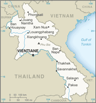
Map of Laos
Modern-day Laos has its roots in the ancient Lao kingdom of Lan Xang, established in the 14th century under King FA NGUM. For 300 years, Lan Xang had influence reaching into present-day Cambodia and Thailand and overall of what is now Laos. After centuries of a gradual decline, Laos came under Siam’s domination (Thailand) from the late 18th century until the late 19th century, when it became part of French Indochina.
The Franco-Siamese Treaty of 1907 defined the current Lao border with Thailand. In 1975, the communist Pathet Lao took control of the government, ending a six-century-old monarchy and instituting a strict socialist regime closely aligned to Vietnam. A gradual, limited return to private enterprise and the liberalization of foreign investment laws began in 1988. Laos became a member of ASEAN in 1997 and the WTO in 2013.
Laos’s names conventional long form: Lao People’s Democratic Republic, traditional short way: Laos, local long form: Sathalanalat Paxathipatai Paxaxon Lao, local short state: Mueang Lao (unofficial), etymology: the name means “Land of the Lao [people].” The name means “Land of the Lao [people].”
Laos’s terrain is typically mostly rugged mountains; some plains and plateaus. The country’s mean elevation: 710 m, elevation extremes; lowest point: Mekong River 70 m, highest point: Phu Bia 2,817 m.
The country’s general climate; tropical monsoon: rainy season (May to November): the dry season (December to April).
The total number of border countries is 5, Burma 238 km, Cambodia 555 km, China 475 km, Thailand 1,845 km, Vietnam 2,161 km are the neighboring nations with the indicated border lengths. Laos’s coastline is 0 km (landlocked country), while its marital claims are: none. Waterways: 4,600 km (primarily on the Mekong River and its tributaries; 2,900 additional km are intermittently navigable by craft drawing less than 0.5 m) (2012). Land use: agricultural land: 10.6%; arable land 6.2%; permanent crops 0.7%; permanent pasture 3.7%; forest: 67.9%; other: 21.5% (2011 estimate).
The population in Laos 7,234,171 (July 2018 estimate), urban population: 38.6% of total population (2015), major urban area’s population: VIENTIANE (capital) 997,000 (2015), while Laos has N/A. Their spoken languages are Lao (official language), French, English, various ethnic languages. Main religions in Laos are Buddhist 66.8%, Christian 1.5%, other 31%, unspecified 0.7% (2005 estimate). The nation uses civil law system similar in form to the French system. It is a(n) communist state, National holiday(s) Republic Day, 2 December (1975).
Economic overview for the country: The government of Laos, one of the few remaining one-party communist states, began decentralizing control and encouraging private enterprise in 1986. Economic growth averaged more than 6% per year in the period 1988-2008. Laos’ development has more recently been amongst the fastest in Asia, averaging more than 7% per year for most of the last decade. Nevertheless, Laos remains a country with an underdeveloped infrastructure, particularly in rural areas. It has a basic but improving road system and limited external and internal land-line telecommunications. Electricity is available to 83% of the population. Agriculture, dominated by rice cultivation in lowland areas, accounts for about 20% of GDP and 73% of total employment. The country has recently faced a persistent current account deficit, falling foreign currency reserves, and growing public debt. Laos’ economy is heavily dependent on capital-intensive natural resource exports.
The economy has benefited from high-profile foreign direct investment in hydropower dams along the Mekong River, copper and gold mining, logging, and construction. However, some projects in these industries have drawn criticism for their environmental impacts. Laos gained Normal Trade Relations status with the US in 2004. It applied for the Generalized System of Preferences trade benefits in 2013 after being admitted to the World Trade Organization earlier. Laos held the chairmanship of ASEAN in 2016. Laos is in the process of implementing a value-added tax system.
The government appears committed to raising the country’s profile among foreign investors and has developed special economic zones replete with generous tax incentives. Still, a limited labor pool, a small domestic market, and corruption remain impediments to investment. Laos also has ongoing problems with the business environment, including onerous registration requirements, a gap between legislation and implementation, and unclear or conflicting regulations.
Natural resources of Laos: timber, hydropower, gypsum, tin, gold, gemstones.
Main export partners for Laos, Southeast Asia are Thailand 30.4%, China 27%, Vietnam 17.6% (2015) for wood products, coffee, electricity, tin, copper, gold, cassava, while the main import partners for the country are: Thailand 60.9%, China 18.6%, Vietnam 7.3% (2015) for machinery and equipment, vehicles, fuel, consumer goods.
When you visit this country in Southeast Asia, consider the natural hazards in Laos: Floods, droughts, while infectious diseases are a degree of risk: very high food or waterborne diseases: bacterial and protozoal diarrhea, hepatitis A, and typhoid fever vectorborne diseases: dengue fever and malaria (2016). Also, note that Laos faces the following environmental issues: Unexploded ordnance, Deforestation, Soil erosion, loss of biodiversity, water pollution, most of the population does not have access to potable water.
You may also be interested in the countries next to Laos around its total: 5,274 km border, like Burma, Cambodia, China, Thailand, Vietnam.