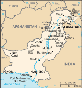
Pakistan (GPS: 30 00 N, 70 00 E) located in Southern Asia, bordering the Arabian Sea, between India on the east and Iran and Afghanistan on the west and China in the north. The country’s area measurements are total: 796,095 sq km; land: 770,875 sq km, water: 25,220 sq km. This sovereign state is slightly more than five times the size of Georgia, slightly less than twice the size of California. The total irrigated land is 202,000 sq km (2012).
One of the important features of Pakistan: Controls Khyber Pass and Bolan Pass, traditional invasion routes between Central Asia and the Indian Subcontinent.
It’s significant, and simultaneously, the principal city, Islamabad’s GPS coordinates are 33 41 N 73 03 E. Islamabad’s local time is 10 hours ahead of Washington DC during Standard Time. The capital’s time difference: UTC+5.
The Indus Valley civilization, one of the oldest in the world and dating back at least 5,000 years, spread over much of what is presently Pakistan. During the second millennium B.C., remnants of this culture fused with the migrating Indo-Aryan peoples. The area underwent successive invasions in subsequent centuries from the Persians, Greeks, Scythians, Arabs (who brought Islam), Afghans, and Turks. The Mughal Empire flourished in the 16th and 17th centuries; The British dominated the region in the 18th century.
The separation in 1947 of British India into the Muslim state of Pakistan (with West and East sections) and largely Hindu India was never satisfactorily resolved, and India and Pakistan fought two wars and a limited conflict – in 1947-48, 1965, and 1999 respectively – over the disputed Kashmir territory. A third war between these countries in 1971 – in which India assisted an indigenous movement reacting to Bengalis’ marginalization in Pakistani politics – resulted in East Pakistan becoming the separate nation of Bangladesh. In response to Indian nuclear weapons testing, Pakistan conducted its own tests in mid-1998. India-Pakistan relations improved in the mid-2000s but have been rocky since the November 2008 Mumbai attacks and have been further strained by attacks in India by militants believed to be based in Pakistan. Imran KHAN took office as prime minister in 2018 after the Pakistan Tehreek-e-Insaaf (PTI) party won a plurality of seats in the July 2018 general elections. Pakistan has been engaged in a decades-long armed conflict with militant groups that target government institutions and civilians, including the Tehreek-e-Taliban Pakistan (TTP) and other militant networks.
Pakistan’s names conventional long form: the Islamic Republic of Pakistan, conventional short form: Pakistan, local long form: Jamhuryat Islami Pakistan, local short form: Pakistan, former: West Pakistan, etymology: the word “pak” means “pure” in Persian or Pashto, while the Persian suffix “-stan” means “place of” or “country,” so the word Pakistan literally means “Land of the pure.” The word “pak” means “pure” in Persian or Pashto, while the Persian suffix “-stan” means “place of” or “country,” so the word Pakistan literally means “Land of the Pure.”
Pakistan’s terrain is typically divided into three major geographic areas: the northern highlands, the Indus River plain in the center and east, and the Balochistan Plateau in the south and west. The country’s mean elevation: 900 m, elevation extremes; lowest point: Indian Ocean 0 m, highest point: K2 8,611 m.
The country’s general climate is mostly hot, desert: temperate in the northwest: arctic in the north.
The total number of border countries is 4, Afghanistan 2,670 km, China 438 km, India 3,190 km, Iran 959 km are the neighboring nations with the indicated border lengths. Pakistan’s coastline is 1,046 km. Its marital claims are territorial sea: 12 nautical miles, contiguous zone: 24 nautical miles, exclusive economic zone: 200 nautical miles, continental shelf: 200 nautical miles or the edge of the continental margin. Waterways: N/A. Land use: agricultural land: 35.2%; arable land 27.6%; permanent crops 1.1%; permanent pasture 6.5%; forest: 2.1%; other: 62.7% (2011 estimate).
The population in Pakistan 207,862,518 (July 2017 estimate) (July 2018 estimate), urban population: 38.8% of total population (2015), major urban area’s population: Karachi 16.618 million; Lahore 8.741 million; Faisalabad 3.567 million; Rawalpindi 2.506 million; Multan 1.921 million; ISLAMABAD (capital) 1.365 million (2015), while Pakistan has the Indus River and its tributaries attract most of the settlement, with Punjab province the most densely populated. Their spoken languages are Punjabi 48%, Sindhi 12%, Saraiki (a Punjabi variant) 10%, Pashto (alternate name, Pashtu) 8%, Urdu (official language) 8%, Balochi 3%, Hindko 2%, Brahui 1%, English (official language; lingua franca of Pakistani elite and most government ministries), Burushaski, and other 8%.
Main religions in Pakistan are Muslim (official) 96.4% (Sunni 85-90%, Shia 10-15%), other (includes Christian and Hindu) 3.6% (2010 estimate). The nation uses common law system with Islamic law influence. It is a(n) federal parliamentary republic, National holiday(s) Pakistan Day (also referred to as Pakistan Resolution Day or Republic Day), 23 March (1940).
Economic overview for the country: Decades of internal political disputes and low foreign investment levels have led to underdevelopment in Pakistan. Pakistan has a large English-speaking population, with English-language skills less prevalent outside urban centers. However, some progress in recent years in both security and energy, a challenging security environment, electricity shortages, and a burdensome investment climate have traditionally deterred investors. Agriculture accounts for one-fifth of output and two-fifths of employment. Textiles and apparel account for more than half of Pakistan’s export earnings; Pakistan’s failure to diversify its exports has left the country vulnerable to world demand shifts. Pakistan’s GDP growth has gradually increased since 2012 and was 5.3% in 2017.
Official unemployment was 6% in 2017, but this fails to capture the true picture because much of the economy is informal, and underemployment remains high. Human development continues to lag behind most of the region. In 2013, Pakistan embarked on a $6.3 billion IMF Extended Fund Facility, which focused on reducing energy shortages, stabilizing public finances, increasing revenue collection, and improving its balance of payments position. The program concluded in September 2016.
Although Pakistan missed several structural reform criteria, it restored macroeconomic stability, improved its credit rating, and boosted growth. The Pakistani rupee has remained relatively stable against the US dollar since 2015, though it declined by about 10% between November 2017 and March 2018. However, the balance of payment concerns has reemerged as a result of a significant increase in imports and weak export and remittance growth. Pakistan must continue to address several longstanding issues, including expanding investment in education, healthcare, and sanitation; Adapting to the effects of climate change and natural disasters; Improving the country’s business environment; And widening its tax base. Given demographic challenges, Pakistan’s leadership will be pressed to implement economic reforms, promote further development of the energy sector, and attract foreign investment to support sufficient economic growth necessary to employ its growing and rapidly urbanizing population, much of which is under the age of 25. To boost development, Pakistan and China are implementing the “China-Pakistan Economic Corridor” (CPEC) with $60 billion in investments targeted towards energy and other infrastructure projects. Pakistan believes CPEC investments will enable over 6% of GDP growth rates by laying the groundwork for increased exports. CPEC-related obligations have raised IMF concern about Pakistan’s capital outflows and external financing needs over the medium term.
Pakistan’s natural resources: arable land, extensive natural gas reserves, limited petroleum, poor quality coal, iron ore, copper, salt, limestone.
Main export partners for Pakistan, Asia are the US 13.1%, UAE 9.1%, Afghanistan 9.1%, China 8.8%, UK 5.4%, Germany 4.9% (2015) for textiles (garments, bed linen, cotton cloth, yarn), rice, leather goods, sporting goods, chemicals, manufactures, carpets and rugs, while the main import partners for the country are: China 28.1%, Saudi Arabia 10.9%, UAE 10.8%, Kuwait 5.6% (2015) for petroleum, petroleum products, machinery, plastics, transportation equipment, edible oils, paper and paperboard, iron and steel, tea.
When you visit this country in Asia, consider the natural hazards in Pakistan: Frequent earthquakes, occasionally severe especially in north and west, flooding along the Indus after heavy rains (July and August), while infectious diseases are a degree of risk: high food or waterborne diseases: bacterial diarrhea, hepatitis A and E, and typhoid fever vectorborne diseases: dengue fever and malaria animal contact disease: rabies (2016). Also, note that Pakistan faces the following environmental issues: Water pollution from raw sewage, industrial wastes, and agricultural runoff, Limited natural freshwater resources, Most of the population does not have access to potable water, Deforestation, Soil erosion, Desertification, Air pollution and noise pollution in urban areas.
You may also be interested in Pakistan’s surrounding countries around its total 7,257 km border, like Afghanistan, China, India, Iran.