Nigeria (GPS: 10 00 N, 8 00 E) located in Western Africa, bordering the Gulf of Guinea, between Benin and Cameroon. The country’s area measurements are total: 923,768 sq km; land: 910,768 sq km, water: 13,000 sq km. This sovereign state is about six times the size of Georgia, slightly more than twice the size of California. The total irrigated land is 2,930 sq km (2012).
One of Nigeria’s important features: The Niger River enters the country in the northwest and flows southward through tropical rain forests and swamps to its delta in the Gulf of Guinea.
It’s significant, and at the same time, the principal city, Abuja’s GPS coordinates are 9 05 N 7 32 E. Abuja’s local time is 6 hours ahead of Washington DC during Standard Time. The capital’s time difference: UTC+1.
For more information on Nigeria, please scroll down below the Google Maps.
Google Maps Nigeria and Abuja, Africa
About Nigeria in detail
Flag of Nigeria
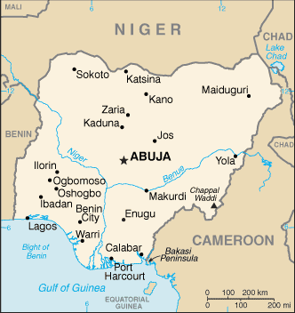
Map of Nigeria
British influence and control over what would become Nigeria and Africa’s most populous country grew through the 19th century. A series of constitutions after World War II granted Nigeria greater autonomy. After independence in 1960, politics were marked by coups and mostly military rule, until the death of a military head of state in 1998 allowed for a political transition. In 1999, a new constitution was adopted, and a peaceful transition to civilian government was completed. The government continues to face the daunting task of institutionalizing democracy and reforming a petroleum-based economy, whose revenues have been squandered through corruption and mismanagement. Besides, Nigeria continues to experience longstanding ethnic and religious tensions.
Although significant irregularities and violence marred both the 2003 and 2007 presidential elections, Nigeria is currently experiencing its longest civilian rule period since independence. The general elections of 2007 marked the first civilian-to-civilian transfer of power in the country’s history, and the elections of 2011 were generally regarded as credible. The 2015 election was heralded because the then-umbrella opposition party, the All Progressives Congress, defeated the long-ruling People’s Democratic Party that had governed since 1999 and assumed the presidency after a peaceful transfer of power. Successful presidential and legislative elections were held in early 2019.
Nigeria’s names conventional long form: the Federal Republic of Nigeria, conventional short form: Nigeria, etymology: named for the Niger River that flows through the west of the country to the Atlantic Ocean; from a native term “Ni Gir” meaning “River Gir.” Named for the Niger River that flows through the west of the country to the Atlantic Ocean; From a native term “Ni Gir,” meaning “River Gir.”
Nigeria’s terrain is typically southern lowlands merge into central hills and plateaus; mountains in the southeast, plains in the north. The country’s mean elevation: 380 m, elevation extremes; lowest point: Atlantic Ocean 0 m, highest point: Chappal Waddi 2,419 m.
The general climate in the country; varies: equatorial in the south, tropical in the center, arid in the north.
The total number of border countries is 4, Benin 809 km, Cameroon 1,975 km, Chad 85 km, Niger 1,608 km are the neighboring nations with the indicated border lengths. Nigeria’s coastline is 853 km, while its marital claims are: territorial sea: 12 nautical miles, exclusive economic zone: 200 nautical miles, continental shelf: 200-m depth or to the depth of exploitation. Waterways: 8,600 km (Niger and Benue Rivers and smaller rivers and creeks) (2011). Land use: agricultural land: 78%; arable land 37.3%; permanent crops 7.4%; permanent pasture 33.3%; forest: 9.5%; other: 12.5% (2011 estimate).
The population in Nigeria 203,452,505 (July 2018 estimate), urban population: 47.8% of total population (2015), major urban area’s population: Lagos 13.123 million; Kano 3.587 million; Ibadan 3.16 million; ABUJA (capital) 2.44 million; Port Harcourt 2.343 million; Benin City 1.496 million (2015), while Nigeria has N/A. Their spoken languages are English (official language), Hausa, Yoruba, Igbo (Ibo), Fulani, over 500 additional indigenous languages. Main religions in Nigeria are Muslim 50%, Christian 40%, indigenous beliefs 10%. The nation uses mixed legal system of English common law, Islamic law (in 12 northern states), and traditional law. It is a(n) federal presidential republic, National holiday(s) Independence Day (National Day), 1 October (1960).
Economic overview for the country: Nigeria is Sub Saharan Africa’s largest economy and relies heavily on oil as its main source of foreign exchange earnings and government revenues. Following the 2008-2009 global financial crises, the banking sector was effectively recapitalized and regulation enhanced. Since then, Nigeria’s economic growth has been driven by growth in agriculture, telecommunications, and services. Economic diversification and strong growth have not translated into a significant decline in poverty levels; Over 62% of Nigeria’s over 180 million people still live in extreme poverty. Despite its strong fundamentals, oil-rich Nigeria has been hobbled by the inadequate power supply, lack of infrastructure, delays in the passage of legislative reforms, an inefficient property registration system, restrictive trade policies, an inconsistent regulatory environment, a slow and ineffective judicial system, unreliable dispute resolution mechanisms, insecurity, and pervasive corruption. Regulatory constraints and security risks have limited new investment in oil and natural gas, and Nigeria’s oil production had been contracting every year since 2012 until a slight rebound in 2017.
President BUHARI, elected in March 2015, has established a cabinet of economic ministers that includes several technocrats. He has announced plans to increase transparency, diversify the economy away from oil, and improve fiscal management. Still, he has taken a primarily protectionist approach that favors domestic producers at the expense of consumers. President BUHARI ran on an anti-corruption platform and has made some headway in alleviating corruption, such as implementing a Treasury Single Account that allows the government to manage better its resources and a more transparent government payroll and personnel system that eliminated duplicate and “ghost workers.”
The government also is working to develop stronger public-private partnerships for roads, agriculture, and power. Nigeria entered recession in 2016 due to lower oil prices and production, exacerbated by militant attacks on oil and gas infrastructure in the Niger Delta region, coupled with detrimental economic policies, including foreign exchange restrictions. GDP growth turned positive in 2017 as oil prices recovered and output stabilized.
Natural resources of Nigeria: natural gas, petroleum, tin, iron ore, coal, limestone, niobium, lead, zinc, arable land.
Main export partners for Nigeria, Africa are India 18.2%, Netherlands 8.5%, Spain 8.2%, Brazil 8.2%, South Africa 7.8%, France 5.2%, Japan 4.5%, Cote d’Ivoire 4.2%, Ghana 4% (2015) for petroleum and petroleum products 95%, cocoa, rubber (2012 estimate), while the main import partners for the country are: China 25.7%, US 6.4%, Netherlands 6.1%, India 4.3% (2015) for machinery, chemicals, transport equipment, manufactured goods, food, and live animals.
When you visit this country in Africa, consider the natural hazards in Nigeria: Periodic droughts, flooding, while infectious diseases are a degree of risk: very high food or waterborne diseases: bacterial and protozoal diarrhea, hepatitis A and E, and typhoid fever vectorborne diseases: malaria, dengue fever, and yellow fever water contact diseases: leptospirosis and schistosomiasis respiratory disease: meningococcal meningitis aerosolized dust or soil contact disease: Lassa fever animal contact disease: rabies (2016).
Also, note that Nigeria faces the following environmental issues: Serious overpopulation and rapid urbanization have led to numerous environmental problems, urban air, and water pollution, Rapid deforestation, Soil degradation, Loss of arable land, Oil pollution – water, air, and soil have suffered serious damage from oil spills.
You may also be interested in the countries next to Nigeria around its total: 4,477 km border, like Benin, Cameroon, Chad, Niger.