Ghana (GPS: 8 00 N, 2 00 W) located in Western Africa, bordering the Gulf of Guinea, between Cote d’Ivoire and Togo. The country’s area measurements are total: 238,533 sq km; land: 227,533 sq km, water: 11,000 sq km. This sovereign state is slightly smaller than Oregon. The total irrigated land is 340 sq km (2012).
One of the critical features of Ghana: Lake Volta is the world’s largest artificial lake (humanmade reservoir) by surface area (8,482 sq km. 3,275 sq mi). The lake was created following the Akosombo Dam’s completion in 1965, which holds back the White Volta and Black Volta Rivers.
It’s significant, and at the same time, the principal city, Accra’s GPS coordinates are 5 33 N 0 13 W. Accra’s local time is 5 hours ahead of Washington DC during Standard Time. The capital’s time difference: UTC 0.
For more information on Ghana, please scroll down below the Google Maps.
Google Maps Ghana and Accra, Africa
About Ghana in detail
Flag of Ghana
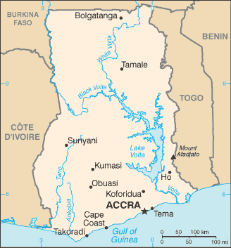
Map of Ghana
Formed from the merger of the British colony of the Gold Coast and the Togoland trust territory, Ghana in 1957 became the first sub-Saharan country in colonial Africa to gain its independence. Ghana endured a series of coups before Lt. Jerry RAWLINGS took power in 1981 and banned political parties. After approving a new constitution and restoring multiparty politics in 1992, RAWLINGS won presidential elections in 1992 and 1996 but constitutionally prevented from running for a third term in 2000.
John KUFUOR of the opposition New Patriotic Party (NPP) succeeded him and was reelected in 2004. John Atta MILLS of the National Democratic Congress won the 2008 presidential election and took over as head of state. Still, he died in July 2012 and was constitutionally succeeded by his vice president, John Dramani MAHAMA, who subsequently won the December 2012 presidential election. In 2016, however, Nana Addo Dankwa AKUFO-ADDO of the NPP defeated MAHAMA, marking the third time that Ghana’s presidency has changed parties since returning to democracy.
Ghana’s names conventional long form: Republic of Ghana, traditional short form: Ghana, former: Gold Coast, etymology: named for the medieval West African kingdom of the same name, but whose location was further north than the modern country. Named for the medieval West African kingdom of the same Name but whose place was further north than the current state.
Ghana’s terrain is typically mostly low plains with dissected plateau in the south-central area. The country’s mean elevation: 190 m, elevation extremes; lowest point: Atlantic Ocean 0 m, highest point: Mount Afadjato 885 m.
The country’s general climate is tropical: warm and comparatively dry along the southeast coast: hot and humid in the southwest: hot and dry in the north.
The total number of border countries is 3, Burkina Faso 602 km, Cote d’Ivoire 720 km, Togo 1,098 km are the neighboring nations with the indicated border lengths. Ghana’s coastline is 539 km, while its marital claims are: territorial sea: 12 nautical miles, contiguous zone: 24 nautical miles, exclusive economic zone: 200 nautical miles, continental shelf: 200 nautical miles. Waterways: 1,293 km (168 km for launches and lighters on Volta, Ankobra, and Tano Rivers; 1,125 km of arterial and feeder waterways on Lake Volta) (2011). Land use: agricultural land: 69.1%; arable land 20.7%; permanent crops 11.9%; permanent pasture 36.5%; forest: 21.2%; other: 9.7% (2011 estimate).
The population in Ghana 28,102,471 (July 2018 estimate), urban population: 54% of total population (2015), major urban area’s population: Kumasi 2.599 million; ACCRA (capital) 2.277 million (2015), while Ghana has N/A. Their spoken languages are: Asante 16%, Ewe 14%, Fante 11.6%, Boron (Brong) 4.9%, Dagomba 4.4%, Dangme 4.2%, Dagarte (Dagaba) 3.9%, Kokomba 3.5%, Akyem 3.2%, Ga 3.1%, other 31.2%. Note: English is the official language language (2010 estimate). Main religions in Ghana are Christian 71.2% (Pentecostal/Charismatic 28.3%, Protestant 18.4%, Catholic 13.1%, other 11.4%), Muslim 17.6%, traditional 5.2%, other 0.8%, none 5.2% (2010 estimate). The nation uses mixed system of English common law and customary law. It is a(n) presidential republic, National holiday(s) Independence Day, 6 March (1957).
Economic overview for the country: Ghana has a market-based economy with relatively few policy barriers to trade and investment compared to other countries in the region, and Ghana is endowed with natural resources. Ghana’s economy was strengthened by a quarter-century of relatively sound management, a competitive business environment, and sustained reductions in poverty levels. It has suffered the consequences of loose fiscal policy, high budget and current account deficits, and a depreciating currency in recent years. Agriculture accounts for about 20% of GDP and employs more than half of the workforce, mainly small landholders. Gold, oil, and cocoa exports, and individual remittances are significant sources of foreign exchange. The expansion of Ghana’s nascent oil industry has boosted economic growth, but the fall in oil prices since 2015 reduced by half Ghana’s oil revenue.
Production at Jubilee, Ghana’s first commercial offshore oilfield, began in mid-December 2010. The output from two more fields, TEN and Sankofa, started in 2016 and 2017, respectively. The country’s first gas processing plant at Atuabo is also producing natural gas from the Jubilee field, providing power to several of Ghana’s thermal power plants. As of 2018, the government’s vital economic concerns include the lack of affordable electricity, lack of a stable domestic revenue base, and the high debt burden. The AKUFO-ADDO administration has made some progress by committing to fiscal consolidation, but much work is still done.
Ghana signed a $920 million extended credit facility with the IMF in April 2015 to address its growing economic crisis. The IMF fiscal targets require Ghana to reduce the deficit by cutting subsidies, decreasing the bloated public sector wage bill, strengthening revenue administration, boosting tax revenues, and improving Ghana’s banking sector. The new administration’s priorities include rescheduling some of Ghana’s $31 billion debt, stimulating economic growth, reducing inflation, and stabilizing the currency. Prospects for new oil and gas production and follow through on tighter fiscal management are likely to help Ghana’s economy in 2018.
Main export partners for Ghana, Africa are India 25.2%, Switzerland 12.2%, China 10.6%, France 5.7% (2015) for oil, gold, cocoa, timber, tuna, bauxite, aluminum, manganese ore, diamonds, horticultural products, while the main import partners for the country are: China 32.6%, Nigeria 14%, Netherlands 5.5%, US 5.4% (2015) for capital equipment, refined petroleum, foodstuffs.
When you visit this country in Africa, consider the natural hazards in Ghana: Dry, dusty, northeastern harmattan winds from January to March, droughts, while infectious diseases are a degree of risk: very high food or waterborne diseases: bacterial and protozoal diarrhea, hepatitis A, and typhoid fever vectorborne diseases: malaria, dengue fever, and yellow fever water contact disease: schistosomiasis respiratory disease: meningococcal meningitis animal contact disease: rabies (2016). Also, note that Ghana faces the following environmental issues: Recurrent drought in the north severely affects agricultural activities, Deforestation, Overgrazing, Soil erosion, Poaching, and habitat destruction threaten wildlife populations, water pollution, Inadequate supplies of potable water.
You may also be interested in the countries next to Ghana around its total: 2,420 km border, like Burkina Faso, Cote d’Ivoire, Togo.