Guinea (GPS: 11 00 N, 10 00 W) located in Western Africa, bordering the North Atlantic Ocean, between Guinea-Bissau and Sierra Leone. The country’s area measurements are total: 245,857 sq km; land: 245,717 sq km, water: 140 sq km. This sovereign state is slightly smaller than Oregon. The total irrigated land is 950 sq km (2012).
One of Guinea’s essential features: The Niger and its important tributary, the Milo River, have their sources in the Guinean highlands.
It’s significant, and at the same time, the principal city, Conakry’s GPS coordinates, are 9 30 N 13 42 W. Conakry’s local time is 5 hours ahead of Washington DC during Standard Time. The capital’s time difference: UTC 0.
For more information on Guinea, please scroll down below the Google Maps.
Google Maps Guinea and Conakry, Africa
About Guinea in detail
Flag of Guinea
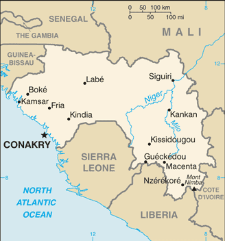
Map of Guinea
Guinea is at a turning point after decades of authoritarian rule since gaining its independence from France in 1958. Sekou TOURE ruled the country as president from independence to his death in 1984. Lansana CONTE came to power in 1984 when the military seized the government after TOURE’s death. Gen. CONTE organized and won presidential elections in 1993, 1998, and 2003, though results were questionable due to a lack of transparency and neutrality in the electoral process. Upon CONTE’s death in December 2008, Capt. Moussa Dadis CAMARA led a military coup, seizing power, and suspending the constitution. His unwillingness to yield to domestic and international pressure to step down led to heightened political tensions that peaked in September 2009 when presidential guards opened fire on an opposition rally, killing more than 150 people. In early December 2009, CAMARA was wounded in an assassination attempt and exiled to Burkina Faso.
A transitional government led by Gen. Sekouba KONATE paved the way for Guinea’s transition to a fledgling democracy. The country held its first free and competitive democratic presidential and legislative elections in 2010 and 2013, respectively, and in October 2015 had a second consecutive presidential election. Alpha CONDE was reelected to a second five-year term as president in 2015, and the National Assembly was seated in January 2014. CONDE’s first cabinet is the first all-civilian government in Guinea. The country held a successful political dialogue in August and September 2016 that brought together the government and opposition to address long-standing tensions. Local elections were held in February 2018, and disputed results in some of the races resulted in ongoing protests against CONDE’s government.
Guinea’s names conventional long form: the Republic of Guinea, traditional short form: Guinea, local long form: Republique de Guinee, local short state: Guinee, former: French Guinea. Note: the country is named after the Guinea region of West Africa that lies along the Gulf of Guinea and stretches north to the Sahel. The country is named after the Guinea region of West Africa that lies along the Gulf of Guinea and stretches north to the Sahel.
Guinea’s terrain is typically generally flat coastal plain, hilly to mountainous interior. The country’s mean elevation: 472 m, elevation extremes; lowest point: Atlantic Ocean 0 m, highest point: Mont Nimba 1,752 m.
The general climate in the country; generally hot and humid: monsoonal-type rainy season (June to November) with southwesterly winds: the dry season (December to May) with northeasterly harmattan winds.
The total number of border countries is 6, Cote d’Ivoire 816 km, Guinea-Bissau 421 km, Liberia 590 km, Mali 1,062 km, Senegal 363 km, Sierra Leone 794 km are the neighboring nations with the indicated border lengths. Guinea’s coastline is 320 km, while its marital claims are: territorial sea: 12 nautical miles, exclusive economic zone: 200 nautical miles. Waterways: 1,300 km (navigable by shallow-draft native craft in the northern part of the Niger River system) (2011). Land use: agricultural land: 58.1%; arable land 11.8%; permanent crops 2.8%; permanent pasture 43.5%; forest: 26.5%; other: 15.4% (2011 estimate).
The population in Guinea 11,855,411 (July 2018 estimate), urban population: 37.2% of total population (2015), major urban area’s population: CONAKRY (capital) 1.936 million (2015), while Guinea has N/A. Their spoken languages are French (official language). Note: each ethnic group has its language. Main religions in Guinea are Muslim 86.7%, Christian 8.9%, animist/other/none 4.4% (2012 estimate). The nation uses civil law system based on the French model. It is a(n) presidential republic, National holiday(s) Independence Day, 2 October (1958).
Economic overview for the country: Guinea is a developing country of approximately 12.9 million people in 2016 that possesses the world’s largest reserves of bauxite and largest untapped high-grade iron ore reserves and gold and diamonds. Besides, Guinea has fertile soil, ample rainfall, and several West African rivers, including Senegal, Niger, and The Gambia. Guinea’s hydro potential is enormous, and the country could be a significant exporter of electricity. The country also has tremendous agriculture potential. Gold, bauxite, and diamonds are Guinea’s main exports.
International investors have shown interest in Guinea’s unexplored mineral reserves, which can propel Guinea’s future growth. Following the death of long-term President Lansana CONTE in 2008 and the coup that followed, international donors, including the G-8, the IMF, and the World Bank, significantly curtailed their development programs in Guinea. However, the IMF approved a 3-year Extended Credit Facility arrangement in 2012, following the December 2010 presidential elections. In September 2012, Guinea achieved Heavily Indebted Poor Country’s completion point status. Future access to international assistance and investment will depend on the government’s ability to be transparent, combat corruption, reform its banking system, improve its business environment, and build infrastructure. In April 2013, the government amended its mining code to reduce taxes and royalties. In 2014, Guinea complied with the Extractive Industries Transparency Initiative’s requirements by publishing its mining contracts. Guinea completed its program with the IMF in October 2016, even though some targeted reforms have been delayed.
Currently, Guinea is negotiating a new IMF program, which will be based on Guinea’s latest five-year economic plan, focusing on the development of higher value-added products, including from the agro-business sector and development of the rural economy. Political instability, a reintroduction of the Ebola virus epidemic, low international commodity prices, and an enduring legacy of corruption, inefficiency, and lack of government transparency are factors that could impact Guinea’s future growth. Economic recovery will be a long process while the government adjusts to lower inflows of international donor aid following the surge of Ebola-related emergency support. Ebola stalled promising economic growth in the 2014-2015 period and impeded several projects, such as offshore oil exploration and the Simandou iron ore project.
However, the economy grew by 6.6% in 2016 and 6.7% in 2017, mainly due to growth from bauxite mining and thermal energy generation as well as the resiliency of the agricultural sector. The 240-megawatt Kaleta Dam, inaugurated in September 2015, has expanded access to electricity for residents of Conakry. Combined with fears of the Ebola virus, continue to undermine Guinea’s economic viability. Guinea’s iron ore industry took a hit in 2016 when investors in the Simandou iron ore project announced plans to divest. In 2017, agriculture output and public investment boosted economic growth, while the mining sector continued to play a prominent role in economic performance. Successive governments have failed to address the country’s crumbling infrastructure. Guinea suffers from chronic electricity shortages; poor roads, rail lines, and bridges; And a lack of access to clean water – all of which continue to plague economic development. The present government, led by President Alpha CONDE, is working to create an environment to attract foreign investment and hopes to have greater participation from western countries and firms in Guinea’s economic development.
Natural resources of Guinea: bauxite, iron ore, diamonds, gold, uranium, hydropower, fish, salt.
Main export partners for Guinea, Africa are India 22.5%, Spain 8.2%, Ireland 7.3%, Germany 6.2%, Belgium 5.5%, Ukraine 5.3%, France 4.1% (2015) for bauxite, gold, diamonds, coffee, fish, agricultural products, while the main import partners for the country are: China 20.4%, Netherlands 5.4%, India 4.4% (2015) for petroleum products, metals, machinery, transport equipment, textiles, grain, and other foodstuffs.
When you visit this country in Africa, consider the natural hazards in Guinea: Hot, dry, dusty harmattan haze may reduce visibility during the dry season, while infectious diseases are a degree of risk: very high food or waterborne diseases: bacterial and protozoal diarrhea, hepatitis A, and typhoid fever vectorborne diseases: malaria, dengue fever, and yellow fever water contact disease: schistosomiasisaerosolized dust or soil contact disease: Lassa fever animal contact disease: rabies (2016). Also, note that Guinea faces the following environmental issues: Deforestation, Inadequate potable water, Desertification, Soil contamination and erosion, Overfishing, overpopulation in the forest region, Poor mining practices leadecologicalntal damage, water pollution, Improper waste disposal.
You may also be interested in the countries next to Guinea around its total: 4,046 km border, like Cote d’Ivoire, Guinea-Bissau, Liberia, Mali, Senegal, Sierra Leone.