Senegal (GPS: 14 00 N, 14 00 W) located in Western Africa, bordering the North Atlantic Ocean, between Guinea-Bissau and Mauritania. The country’s area measurements are total: 196,722 sq km; land: 192,530 sq km, water: 4,192 sq km. This sovereign state is slightly smaller than South Dakota. The total irrigated land is 1,200 sq km (2012).
One of the essential features of Senegal: Westernmost country on the African continent. The Gambia is almost an enclave within Senegal.
It’s significant, and simultaneously, the principal city, Dakar’s GPS coordinates are 14 44 N 17 38 W. Dakar’s local time is 5 hours ahead of Washington DC during Standard Time. The capital’s time difference: UTC 0.
For more information on Senegal, please scroll down below the Google Maps.
Google Maps Senegal and Dakar, Africa
About Senegal in detail
Flag of Senegal
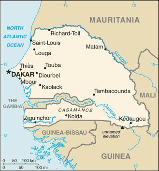
Map of Senegal
The French colonies of Senegal and French Sudan were merged in 1959 and granted independence in 1960 as the Mali Federation. The union broke up after only a few months. Senegal joined with The Gambia to form the nominal confederation of Senegambia in 1982. The envisaged integration of the two countries was never implemented, and the union dissolved in 1989. The Movement of Democratic Forces in the Casamance has led to a low-level separatist insurgency in southern Senegal since the 1980s. Several attempts at reaching a comprehensive peace agreement have failed to resolve the conflict but, despite sporadic incidents of violence, an unofficial cease-fire has remained largely in effect since 2012.
Senegal remains one of Africa’s most stable democracies and has a long history of participating in international peacekeeping and regional mediation. Senegal was ruled by the Socialist Party of Senegal, first under President Léopold Sédar SENGHOR, and then President Abdou DIOUF, for 40 years until Abdoulaye WADE was elected president in 2000. He was re-elected in 2007 and, during his two terms, amended Senegal’s constitution over a dozen times to increase executive power and weaken the opposition. His decision to run for a third presidential term sparked an enormous public backlash that led to his defeat in a March 2012 runoff with Macky SALL. A 2016 constitutional referendum reduced the term to five years with a maximum of two consecutive terms for future presidents – the change did not apply to SALL’s first term. SALL won his bid for re-election in February 2019; His term will end in 2024. A month after the election, the National Assembly voted to abolish the office of the prime minister. Opposition organizations and civil society have criticized the decision as a further concentration of power in the executive branch at the expense of the legislative and judicial branches.
Senegal’s names conventional long form: the Republic of Senegal, traditional short form: Senegal, local long form: Republique du Senegal, local transient state: Senegal, former: Senegambia (along with The Gambia), Mali Federation, etymology: named for the Senegal River that forms the northern border of the country; many theories exist for the origin of the river name; perhaps the most widely cited derives the name from “Azenegue,” the Portuguese appellation for the Berber Zenaga people who lived north of the river. Named for the Senegal River that forms the northern border of the country; Many theories exist for the origin of the river Name; Perhaps the most widely cited derives the Name from “Azenegue,” the Portuguese appellation for the Berber Zenaga people who lived north of the river.
Senegal’s terrain is typically generally low, rolling, plains rising to foothills in the southeast. The country’s mean elevation: 69 m, elevation extremes; lowest point: Atlantic Ocean 0 m, highest point: unnamed elevation southwest of Kedougou 581 m.
The country’s general climate is tropical: hot, humid: rainy season (May to November) has strong southeast winds: the dry season (December to April) dominated by hot, dry, harmattan wind.
The total number of border countries is 5, The Gambia 749 km, Guinea 363 km, Guinea-Bissau 341 km, Mali 489 km, Mauritania 742 km are the neighboring nations with the indicated border lengths. Senegal’s coastline is 531 km. Its marital claims are territorial sea: 12 nautical miles, contiguous zone: 24 nautical miles, exclusive economic zone: 200 nautical miles, continental shelf: 200 nautical miles or the edge of the continental margin. Waterways: 1,000 km (primarily on the Senegal, Saloum, and Casamance Rivers) (2012). Land use: agricultural land: 46.8%; arable land 17.4%; permanent crops 0.3%; permanent pasture 29.1%; forest: 43.8%; other: 9.4% (2011 estimate).
The population in Senegal 15,020,945 (July 2018 estimate), urban population: 43.7% of total population (2015), major urban area’s population: DAKAR (capital) 3.52 million (2015), while Senegal has N/A. Their spoken languages are French (official language), Wolof, Pulaar, Jola, Mandinka. Main religions in Senegal are Muslim 95.4% (most adhere to one of the four main Sufi brotherhoods), Christian 4.2% (mostly Roman Catholic), animist 0.4% (2010-11 estimate). The nation uses civil law system based on French law; judicial review of legislative acts in Constitutional Court. It is a(n) presidential republic, National holiday(s) Independence Day, 4 April (1960).
Economic overview for the country: Senegal’s economy is driven by mining, construction, tourism, fisheries, and agriculture, which are the primary sources of employment in rural areas. The country’s key export industries include phosphate mining, fertilizer production, agricultural products, and commercial fishing, and Senegal is also working on oil exploration projects. It relies heavily on donor assistance, remittances, and foreign direct investment. Senegal reached a growth rate of 7% in 2017 due to strong performance in agriculture despite erratic rainfall. President Macky SALL, who elected in March 2012 under a reformist policy agenda, inherited an economy with high energy costs, a challenging business environment, and an overspending culture. President SALL unveiled an ambitious economic plan, the Emerging Senegal Plan (ESP), which aims to implement priority economic reforms and investment projects to increase economic growth while preserving macroeconomic stability and debt sustainability.
Bureaucratic bottlenecks and a challenging business climate are among the perennial challenges that may slow this plan’s implementation. Senegal receives technical support from the IMF under a Policy Support Instrument (PSI) to assist with implementing the ESP. The PSI implementation continues to be satisfactory, as concluded by the IMF’s fifth review in December 2017.
Financial markets have signaled confidence in Senegal through successful Eurobond issuances in 2014, 2017, and 2018. The government is focusing on 19 projects under the ESP to continue. The government’s goal under the ESP is the structural transformation of the economy. Key projects include the Thiès-Touba Highway, the new international airport opened in December 2017, and upgrades to energy infrastructure. The cost of electricity is a chief constraint for Senegal’s development. Electricity prices in Senegal are among the highest in the world. Power Africa, a US presidential initiative led by USAID, supports Senegal’s plans to improve reliability and generate capacity.
Natural resources of Senegal: fish, phosphates, iron ore.
Main export partners for Senegal, Africa are Mali 12.8%, Switzerland 9.7%, India 5.9%, Cote d’Ivoire 5.3%, China 5.1%, UAE 4.1%, France 4.1% (2015) for fish, groundnuts (peanuts), petroleum products, phosphates, cotton, while the main import partners for the country are: France 17.9%, China 10%, Nigeria 8.7%, India 5.6%, Spain 4.9%, Netherlands 4.5% (2015) for food and beverages, capital goods, fuels.
When you visit this country in Africa, consider the natural hazards in Senegal: Lowlands seasonally flooded, periodic droughts, while infectious diseases are a degree of risk: very high food or waterborne diseases: bacterial and protozoal diarrhea, hepatitis A, and typhoid fever vectorborne diseases: malaria and dengue fever water contact disease: schistosomiasis respiratory disease: meningococcal meningitis animal contact disease: rabies (2016). Also, note that Senegal faces the following environmental issues: Deforestation, Overgrazing, Soil erosion, Desertification, Periodic droughts, Seasonal flooding, Overfishing, weak environmental protective laws, wildlife populations threatened by poaching.
You may also be interested in the countries next to Senegal around its total: 2,684 km border, like The Gambia, Guinea, Guinea-Bissau, Mali, Mauritania.