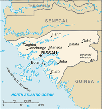
Guinea-Bissau (GPS: 12 00 N, 15 00 W) located in Western Africa, bordering the North Atlantic Ocean, between Guinea and Senegal. The country’s area measurements are total: 36,125 sq km; land: 28,120 sq km, water: 8,005 sq km. This sovereign state is slightly less than three times the size of Connecticut. The total irrigated land is 250 sq km (2012).
One of the essential features of Guinea-Bissau: This small country is swampy along its western coast and low-lying inland.
It’s significant, and at the same time, the principal city, Bissau’s GPS coordinates are 11 51 N 15 35 W. Bissau’s local time is 5 hours ahead of Washington DC during Standard Time. The capital’s time difference: UTC 0.
Since independence from Portugal in 1974, Guinea-Bissau has experienced considerable political and military upheaval. In 1980, a military coup established authoritarian General Joao Bernardo ‘Nino’ VIEIRA as president. Despite eventually setting a path to a market economy and multiparty system, VIEIRA’s regime was characterized by suppressing political opposition and the purging of political rivals. Several coup attempts through the 1980s and early 1990s failed to unseat him.
In 1994 VIEIRA was elected president in the country’s first free, multiparty election. A military mutiny and resulting civil war in 1998 eventually led to VIEIRA’s ouster in May 1999. In February 2000, a transitional government turned over power to opposition leader Kumba YALA after he was elected president in transparent polling. In September 2003, after only three years in office, YALA was overthrown in a bloodless military coup, and businessman Henrique ROSA was sworn in as interim president. In 2005, former President VIEIRA was reelected, pledging to pursue economic development and national reconciliation; He was assassinated in March 2009. Malam Bacai SANHA was elected in an emergency election held in June 2009, but he passed away in January 2012 from a long-term illness. A military coup in April 2012 prevented Guinea-Bissau’s second-round presidential election – to determine SANHA’s successor – from taking place. Following mediation by the Economic Community of Western African States, a transitional civilian government assumed power in 2012 and remained until Jose Mario VAZ won a free and fair election in 2014.
Beginning in 2015, a political dispute between factions in the ruling PAIGC party brought government gridlock. It was not until April 2018 that a consensus prime minister could be appointed. The national legislature reopened (having been closed for two years), and a new government formed under Prime Minister Aristides GOMES. In March 2019, the government held legislative elections, voting in the PAIGC as the ruling party; However, President VAZ continues to perpetuate a political stalemate by refusing to name PAICG President Domingos SIMOES PEREIRA Prime Minister.
Guinea-Bissau’s names conventional long form: the Republic of Guinea-Bissau, traditional short form: Guinea-Bissau, local long form: Republica da Guine-Bissau, local short state: Guine-Bissau, former: Portuguese Guinea. Note: the country is named after the Guinea region of West Africa that lies along the Gulf of Guinea and stretches north to the Sahel; “Bissau” distinguishes the country from neighboring Guinea. The country is named after the Guinea region of West Africa that lies along the Gulf of Guinea and stretches north to the Sahel; “Bissau,” the capital city’s name, distinguishes the country from neighboring Guinea.
Guinea-Bissau’s terrain is typically mostly low-lying coastal plain with a profoundly indented estuarine coastline rising to savanna in the east; numerous off-shore islands, including the Arquipelago Dos Bijagos consisting of 18 main islands and many small islets. The country’s mean elevation: 70 m, elevation extremes; lowest point: Atlantic Ocean 0 m, highest point: unnamed elevation in the eastern part of the country 300 m.
The general climate in the country; tropical: generally hot and humid: monsoonal-type rainy season (June to November) with southwesterly winds: the dry season (December to May) with northeasterly harmattan winds.
The total number of border countries is 2, Guinea 421 km, Senegal 341 km are the neighboring nations with the indicated border lengths. Guinea-Bissau’s coastline is 350 km, while its marital claims are: territorial sea: 12 nautical miles, exclusive economic zone: 200 nautical miles. Waterways: (rivers are partially navigable; many inlets and creeks provide shallow-water access to many interiors) (2012). Land use: agricultural land: 44.8%; arable land 8.2%; permanent crops 6.9%; permanent pasture 29.7%; forest: 55.2%; other: 0% (2011 estimate).
The population in Guinea-Bissau 1,833,247 (July 2018 estimate), urban population: 49.3% of total population (2015), major urban area’s population: BISSAU (capital) 492,000 (2015), while Guinea-Bissau has N/A. Their spoken languages are: Crioulo 90.4%, Portuguese 27.1% (official language), French 5.1%, English 2.9%, other 2.4%. Note shares sum to more than 100% because some respondents gave more than one answer on the census (2008 estimate). Main religions in Guinea-Bissau are Muslim 45.1%, Christian 22.1%, animist 14.9%, none 2%, unspecified 15.9% (2008 estimate). The nation uses mixed legal system of civil law, which incorporated Portuguese law at independence and influenced by early French civil code and customary law. It is a(n) semi-presidential republic, National holiday(s) Independence Day, 24 September (1973).
Economic overview for the country: Guinea-Bissau depends on subsistence agriculture, cashew nut exports, and foreign assistance. Two out of three Bissau-Guineans remain below the absolute poverty line. The legal economy is based on cashews and fishing. Illegal logging and trafficking in narcotics also play significant roles. The combination of limited economic prospects, weak institutions, and favorable geography has made this West African country a way station for Europe’s drugs. Guinea-Bissau has substantial potential to develop mineral resources, including phosphates, bauxite, and mineral sands. Offshore oil and gas exploration has begun.
The country’s climate and soil make it feasible to grow a wide range of cash crops, fruit, vegetables, and tubers; However, cashews generate more than 80% of export receipts and are the main source of income for many rural communities. The government was deposed in August 2015, and since then, a political stalemate has resulted in weak governance and reduced donor support. The country participates in a three-year, IMF extended credit facility program that was suspended because of a planned bank bailout. The program was renewed in 2017, but the major donors of direct budget support (the EU, World Bank, and African Development Bank) have halted their programs indefinitely. Diversification of the economy remains a key policy goal, but Guinea-Bissau’s poor infrastructure and business climate will constrain this effort.
Natural resources of Guinea-Bissau: fish, timber, phosphates, bauxite, clay, granite, limestone, unexploited deposits of petroleum.
Main export partners for Guinea-Bissau, Africa are India 63.5%, Nigeria 20.3%, China 5.7%, Togo 5.6% (2015) for fish, shrimp; cashews, peanuts, palm kernels, raw, and sawn lumber, while the main import partners for the country are: Portugal 27.1%, Senegal 12.8%, China 6.5%, Spain 5.5%, Cuba 4.8% (2015) for foodstuffs, machinery and transport equipment, petroleum products.
When you visit this country in Africa, consider the natural hazards in Guinea-Bissau: Hot, dry, dusty harmattan haze may reduce visibility during the dry season, brush fires, while infectious diseases are the degree of risk: very high food or waterborne diseases: bacterial and protozoal diarrhea, hepatitis A, and typhoid fever vectorborne diseases: malaria, dengue fever, and yellow fever water contact disease: schistosomiasis animal contact disease: rabies (2016). Also, note that Guinea-Bissau faces the following environmental issues: Deforestation (rampant felling of trees for timber and agricultural purposes), Soil erosion, Overgrazing, Overfishing.
You may also be interested in the countries next to Guinea-Bissau around its total: 762 km border, like Guinea, Senegal.