Cuba (GPS: 21 30 N, 80 00 W) is located in the Caribbean, an island between the Caribbean Sea and the North Atlantic Ocean, 150 km south of Key West, Florida. The country’s area measurements are total: 110,860 sq km; land: 109,820 sq km, water: 1,040 sq km. This sovereign state is slightly smaller than Pennsylvania. The total irrigated land is 8,700 sq km (2012).
One of Cuba’s essential features: The largest country in the Caribbean and the westernmost island of the Greater Antilles.
It’s significant, and at the same time, the principal city, Havana’s GPS coordinates are 23 07 N 82 21 W. Havana’s local time is the same as Washington DC during Standard Time. The capital’s time difference: UTC-5, note; Daylight saving time: +1hr begins second Sunday in March; ends first Sunday in November; note – Cuba is known to alter the schedule of DST on short notice in an attempt to conserve electricity for lighting.
For more information on Cuba, please scroll down below the Google Maps.
Google Maps Cuba and Havana, Central America and the Caribbean
About Cuba in detail
Flag of Cuba
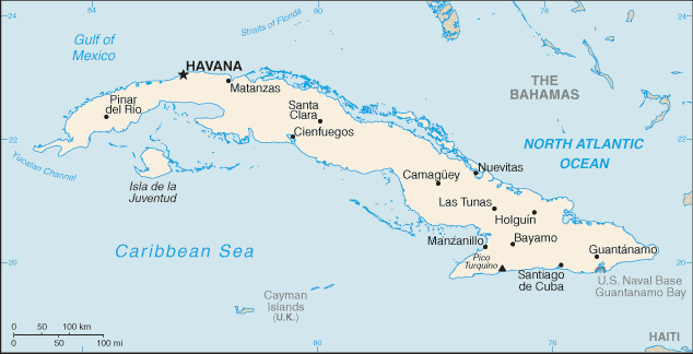
Map of Cuba
The native Amerindian population of Cuba began to decline after the European discovery of the island by Christopher COLUMBUS in 1492 and following its development as a Spanish colony during the next several centuries. Large numbers of African slaves imported to work the coffee and sugar plantations, and Havana became the launching point for the annual treasure fleets bound for Spain from Mexico and Peru. Spanish rule eventually provoked an independence movement, and occasional rebellions were harshly suppressed. US intervention during the Spanish-American War in 1898 assisted the Cubans in overthrowing Spanish rule.
The Treaty of Paris established Cuban independence from Spain in 1898. Following three-and-a-half years of subsequent US military rule, Cuba became an independent republic in 1902. The island experienced a string of governments mostly dominated by the military and corrupt politicians. Fidel CASTRO led a rebel army to victory in 1959; His authoritarian rule held the subsequent regime together for nearly five decades. He stepped down as president in February 2008 in favor of his younger brother Raul CASTRO. Cuba’s communist revolution, with Soviet support, was exported throughout Latin America and Africa during the 1960s, 1970s, and 1980s. Miguel DIAZ-CANEL Bermudez, hand-picked by Raul CASTRO to succeed him, was approved as president by the National Assembly and took office on 19 April 2018. The country faced a severe economic downturn in 1990 following the withdrawal of former Soviet subsidies worth $4-6 billion annually.
Cuba traditionally and consistently portrays the US embargo, in place since 1961, as the source of its difficulties. As a result of efforts begun in December 2014 to re-establish diplomatic relations with the Cuban Government, which were severed in January 1961, the US and Cuba reopened embassies in their respective countries in July 2015. The embargo remains in place, and the relationship between the US and Cuba remains tense. Illicit migration of Cuban nationals to the US via maritime and overland routes has been a longstanding challenge. On 12 January 2017, the US and Cuba signed a Joint Statement ending the so-called “wet-foot, dry-foot” policy – by which Cuban nationals who reached US soil were permitted to stay. Illicit Cuban migration by sea has since dropped significantly, but land border crossings continue. In FY 2018, the US Coast Guard interdicted 312 Cuban nationals at sea. In FY 2018, 7,249 Cuban migrants presented themselves at various land border ports of entry throughout the US.
Cuba’s name conventional long form: the Republic of Cuba, traditional short form: Cuba, local long form: Republica de Cuba, local short form: Cuba, etymology: name derives from the Taino Indian designation for the island “coabana” meaning “great place.” The name derives from the Taino Indian title for the island “coabana,” meaning “great place.”
Cuba’s terrain is typically flat to rolling plains, with rugged hills and mountains in the southeast. The country’s mean elevation: 108 m, elevation extremes; lowest point: the Caribbean Sea 0 m, highest point: Pico Turquino 1,974 m.
The country’s general climate is tropical: moderated by trade winds: the dry season (November to April): rainy season (May to October).
The total number of border countries is 1, US Naval Base at Guantanamo Bay 28.5 km. Note: Guantanamo Naval Base is leased by the US and remains part of Cuba’s neighboring nations with the indicated border lengths. Cuba’s coastline is 3,735 km, while its marital claims are: territorial sea: 12 nautical miles, contiguous zone: 24 nautical miles, exclusive economic zone: 200 nautical miles. Waterways: 240 km (almost all navigable inland waterways are near the mouths of rivers) (2011). Land use: agricultural land: 60.3%; arable land 33.8%; permanent crops 3.6%; permanent pasture 22.9%; forest: 27.3%; other: 12.4% (2011 estimate).
The population in Cuba 11,116,396 (July 2018 estimate), urban population: 77.1% of total population (2015), central metropolitan area’s population: HAVANA (capital) 2.137 million (2015), while Cuba has large population clusters found throughout the country, the more significant ones being in, the larger towns and cities, particularly the capital of Havana. Their spoken languages are Spanish (official language). Cuba’s main religions are nominally Roman Catholic 85%, Protestant, Jehovah’s Witnesses, Jewish, Santeria. Note: before CASTRO assuming power. The nation uses civil law system based on the Spanish civil code. It is a(n) communist state, National holiday(s) Triumph of the Revolution (Liberation Day), 1 January (1959).
Economic overview for the country: The government balances the need for loosening its socialist financial system against a desire for firm political control. In April 2011, the government held the first Cuban Communist Party Congress in almost 13 years, during which leaders approved a plan for wide-ranging economic changes. Since then, the government has slowly and incrementally implemented limited economic reforms, including allowing Cubans to buy electronic appliances and cell phones, stay in hotels, and buy and sell used cars.
The government has cut state sector jobs as part of the reform process, and it has opened up some retail services to “self-employment,” leading to the rise of so-called “cuentapropistas” or entrepreneurs. More than 500,000 Cuban workers are currently registered as self-employed. The Cuban regime has updated its economic model to include permitting the private ownership and sale of real estate and new vehicles, allowing private farmers to sell agricultural goods directly to hotels, allowing the creation of non-agricultural cooperatives, adopting a new foreign investment law, and launching a “Special Development Zone” around the Mariel port. Since 2016, Cuba has attributed slowed economic growth to problems with petroleum product deliveries from Venezuela. Since late 2000, Venezuela has provided petroleum products to Cuba on preferential terms, supplying nearly 100,000 barrels per day. In part, Cuba paid for the oil with Cuban personnel services in Venezuela, including some 30,000 medical professionals.
Natural resources of Cuba: cobalt, nickel, iron ore, chromium, copper, salt, timber, silica, petroleum, arable land.
Main export partners for Cuba, Central America, and the Caribbean are Canada 17.7%, Venezuela 13.8%, China 13%, Netherlands 6.4%, Spain 5.4%, Belize 4.7% (2015) for petroleum, nickel, medical products, sugar, tobacco, fish, citrus, coffee, while the main import partners for the country are: Venezuela 31.8%, China 17.6%, Spain 10%, Brazil 4.8% (2015) for petroleum, food, machinery and equipment, chemicals.
When you visit this country in Central America and the Caribbean, consider the natural hazards in Cuba: The east coast is subject to hurricanes from August to November (in general, the country averages about one hurricane every other year), droughts are common, while infectious diseases are a degree of risk: intermediate food or waterborne diseases: bacterial diarrhea and hepatitis A vectorborne diseases: dengue fever. Note: active local transmission of Zika virus by Aedes species mosquitoes has been identified in this country (as of August 2016); it poses a significant risk (a large number of cases possible) among US citizens if bitten by an infective mosquito; other less common ways to get Zika are through sex, via blood transfusion, or during pregnancy, in which the pregnant woman passes Zika virus to her fetus (2016). Also, note that Cuba faces the following environmental issues: Soil degradation and desertification (brought on by low farming techniques and natural disasters) are the main ecological problems, Biodiversity loss, Deforestation, Air, and water pollution.
You may also be interested in the countries next to Cuba around its total: 28.5 km border, like the United States.