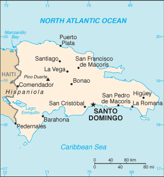
Dominican Republic (GPS: 19 00 N, 70 40 W) located in the Caribbean, eastern two-thirds of the island of Hispaniola, between the Caribbean Sea and the North Atlantic Ocean, east of Haiti. The country’s area measurements are total: 48,670 sq km; land: 48,320 sq km, water: 350 sq km. This sovereign state is slightly more than twice the size of New Hampshire. The total irrigated land is 3,070 sq km (2012).
One of the essential features of Dominican Republic: Shares island of Hispaniola with Haiti (eastern two-thirds makes up the Dominican Republic, western one-third is Haiti). The second-largest country in the Antilles (after Cuba). Geographically diverse with the Caribbean’s tallest mountain, Pico Duarte, and lowest elevation and largest lake, Lago Enriquillo.
It’s significant, and at the same time, the principal city, Santo Domingo’s GPS coordinates are 18 28 N 69 54 W. Santo Domingo’s local time is 1 hour ahead of Washington DC during Standard Time. The capital’s time difference: UTC-4.
Google Maps Dominican Republic and Santo Domingo, Central America and the Caribbean
About Dominican Republic in detail
Flag of Dominican Republic
Map of Dominican Republic
The Taino – indigenous inhabitants of Hispaniola prior to the arrival of the Europeans – divided the island into five chiefdoms and territories. Christopher COLUMBUS explored and claimed the island on his first voyage in 1492; It became a springboard for the Spanish conquest of the Caribbean and the American mainland. In 1697, Spain recognized French dominion over the western third of the island, which in 1804 became Haiti. The remainder of the island, by then known as Santo Domingo, sought to gain its own independence in 1821 but was conquered and ruled by the Haitians for 22 years; It finally attained independence as the Dominican Republic in 1844. In 1861, the Dominicans voluntarily returned to the Spanish Empire, but two years later they launched a war that restored independence in 1865.
A legacy of the unsettled, mostly non-representative rule followed, capped by the dictatorship of Rafael Leonidas TRUJILLO from 1930 to 1961. Juan BOSCH was elected president in 1962 but was deposed in a military coup in 1963. In 1965, the US-led interventduringt of a civil war sparked by an uprising to restore BOSCH. In 1966, Joaquin BALAGUER defeated BOSCH in the presidential election. BALAGUER maintained a tight grip on power for most of the next 30 years when international reaction to flawed elections forced him to curtail his term in 1996. Since then, regular competitive elections have been held in which opposition candidates have won the presidency. Former President Leonel FERNANDEZ Reyna (first term 1996-2000) won election to a new term in 2004 following a constitutional amendment allowing presidents to serve more than one word. She was later reelected to a second consecutive term. In 2012, Danilo MEDINA Sanchez became president; He was reelected in 2016.
Dominican Republic’s names conventional long form: the Dominican Republic, traditional short form: The Dominican, local long way: Republica Dominicana, local short state: La Dominicana, etymology: the country name derives from the capital city of Santo Domingo (Saint Dominic). The country name derives from the capital city of Santo Domingo (Saint Dominic).
Dominican Republic’s terrain is typically rugged highlands and mountains interspersed with fertile valleys. The country’s mean elevation: 424 m, elevation extremes; lowest point: Lago Enriquillo -46 m, highest point: Pico Duarte 3,175 m.
The general climate in the country; tropical maritime: little seasonal temperature variation: seasonal variation in rainfall.
The total number of border countries is 1, Haiti 376 km are the neighboring nations with the indicated border lengths. Dominican Republic’s coastline is 1,288 km, while its marital claims are: measured from claimed archipelagic straight baselines territorial sea: 12 nautical miles, contiguous zone: 24 nautical miles, exclusive economic zone: 200 nautical miles, continental shelf: 200 nautical miles or to the edge of the continental margin. Waterways: N/A. Land use: agricultural land: 51.5%; arable land 16.6%; permanent crops 10.1%; permanent pasture 24.8%; forest: 40.8%; other: 7.7% (2011 estimate).
The population in the Dominican Republic 10,298,756 (July 2018 estimate), urban population: 79% of total population (2015), major urban area’s population: SANTO DOMINGO (capital) 2.945 million (2015), while the Dominican Republic has coastal development is significant, especially in the southern coastal plains and the Cibao Valley, where population density is highest; smaller population clusters exist in the interior mountains (Cordillera Central). Their spoken languages are Spanish (official language). The main religions in the Dominican Republic are Roman Catholic 95%, other 5%. The nation uses civil law system based on the French civil code; the Criminal Procedures Code modified in 2004 to include important elements of an accusatory system. It is a(n) presidential republic, National holiday(s) Independence Day, 27 February (1844).
Economic overview for the country: The Dominican Republic was for most of its history primarily an exporter of sugar, coffee, and tobacco, but over the last three decades, the economy has become more diversified as the service sector has overtaken agriculture as the economy’s largest employer, due to growth in construction, tourism, and free trade zones. The mining sector has also played a more significant role in the export market since late 2012 with the commencement of the extraction phase of the Pueblo Viejo Gold and Silvermine, one of the largest gold mines in the world. For the last 20 years, the Dominican Republic has been one of Latin America’s fastest-growing economies.
The economy rebounded from the global recession in 2010-2016, and the fiscal situation is improving. A tax reform package passed in November 2012, a reduction in government spending, and lower energy costs helped to narrow the central government budget deficit from 6.6% of GDP in 2012 to 2.6% in 2016, and public debt is declining. Significant income inequality, high unemployment, and underemployment remain critical long-term challenges; The poorest half of the population receives less than one-fifth of GDP, while the wealthiest 10% enjoys nearly 40% of GDP. The economy is highly dependent upon the US, the destination for approximately half of exports and the source of 40% of imports. Remittances from the US amount to about 7% of GDP, equivalent to about a third of exports and two-thirds of tourism receipts. The Central America-Dominican Republic Free Trade Agreement came into force in March 2007, boosting investment and manufacturing exports.
Main export partners for the Dominican Republic, Central America, and the Caribbean are US 42.5%, Haiti 16.5%, Canada 8.1%, India 4.8% (2015) for gold, silver, cocoa, sugar, coffee, tobacco, meats, consumer goods, while the main import partners for the country are: the US 42%, China 9.2%, Venezuela 5.6%, Trinidad and Tobago 4.5%, Mexico 4.4% (2015) for petroleum, foodstuffs, cotton and fabrics, chemicals and pharmaceuticals.
When you visit this country in Central America and the Caribbean, consider the natural hazards in the Dominican Republic: Lies in the middle of the hurricane belt and subject to severe storms from June to October, occasional flooding, periodic droughts, while infectious diseases are the degree of risk: high food or waterborne diseases: bacterial diarrhea, hepatitis A, and typhoid fever vectorborne disease: dengue fever. Note: active local transmission of Zika virus by Aedes species mosquitoes has been identified in this country (as of August 2016); it poses a substantial risk (a large number of cases possible) among US citizens if bitten by an infective mosquito; other less common ways to get Zika are through sex, via blood transfusion, or during pregnancy, in which the pregnant woman passes Zika virus to her fetus (2016). Also, note that the Dominican Republic faces the following environmental issues: Water shortages, Soil eroding into the sea damages coral reefs, Deforestation.
You may also be interested in the countries next to the Dominican Republic around its total: 376 km border, like Haiti.