Lesotho (GPS: 29 30 S, 28 30 E) is located in Southern Africa and South Africa. The country’s area measurements are total: 30,355 sq km; land: 30,355 sq km, water: 0 sq km. This sovereign state is slightly smaller than Maryland. The total irrigated land is 30 sq km (2012).
One of Lesotho’s essential features: Landlocked, an enclave of (surrounded by) South Africa. Mountainous, more than 80% of the country is 1,800 m above sea-level.
It’s significant, and simultaneously, the principal city, Maseru’s GPS coordinates are 29 19 S 27 29 E. Maseru’s local time is 7 hours ahead of Washington DC during Standard Time. The capital’s time difference: UTC+2.
For more information on Lesotho, please scroll down below the Google Maps.
Google Maps Lesotho and Maseru, Africa
About Lesotho in detail
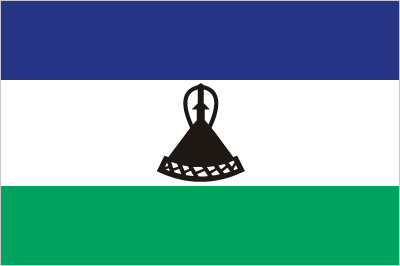
Flag of Lesotho
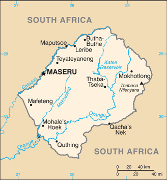
Map of Lesotho
Basutoland was renamed the Kingdom of Lesotho upon independence from the UK in 1966. The Basotho National Party ruled the country during its first two decades. King MOSHOESHOE II was exiled in 1990 but returned to Lesotho in 1992 and was reinstated in 1995 and subsequently succeeded by his son, King LETSIE III, in 1996. Constitutional government was restored in 1993 after seven years of military rule. In 1998, violent protests and a military mutiny following a contentious election prompted a brief but bloody intervention by South African and Botswana military forces under the Southern African Development Community’s aegis. Subsequent constitutional reforms restored relative political stability.
Peaceful parliamentary elections were held in 2002, but the National Assembly elections in 2007 were hotly contested, and aggrieved parties disputed how the electoral law was applied to award proportional seats in the Assembly. In 2012, competitive elections involving 18 parties saw Prime Minister Motsoahae Thomas THABANE form a coalition government – the first in the country’s history – that ousted the 14-year incumbent, Pakalitha MOSISILI, who peacefully transferred power the following month. MOSISILI returned to power in snap elections in February 2015 after the collapse of THABANE’s coalition government and an alleged attempted military coup. In June 2017, THABANE returned to become prime minister.
Lesotho’s names conventional long form: the Kingdom of Lesotho, traditional short form: Lesotho, local long form: the Kingdom of Lesotho, local short state: Lesotho, former: Basutoland, etymology: the name translates as “Land of the Sesotho speakers.”
Lesotho’s terrain is typically mostly highland with plateaus, hills, and mountains. The country’s mean elevation: 2,161 m, elevation extremes; lowest point: junction of the Orange and Makhaleng Rivers 1,400 m, highest point: Thabana Ntlenyana 3,482 m.
The country’s general climate is temperate: cool to cold, dry winters: hot, wet summers.
The total number of border countries is 1, South Africa 1,106 km are the neighboring nations with the indicated border lengths. Lesotho’s coastline is 0 km (landlocked country), while its marital claims are: none. Waterways: N/A. Land use: agricultural land: 76.1%; arable land 10.1%; permanent crops 0.1%; permanent pasture 65.9%; forest: 1.5%; other: 22.4% (2011 estimate).
The population in Lesotho 1,962,461 (July 2018 estimate), urban population: 27.3% of total population (2015), major urban area’s population: MASERU (capital) 267,000 (2014), while Lesotho has N/A. Their spoken languages are Sesotho (official language) (southern Sotho), English (official language), Zulu, Xhosa. The main religions in Lesotho are Christian 80%, indigenous beliefs 20%. The nation uses a mixed legal system of English common law and Roman-Dutch law; judicial review of legislative acts in High Court and Court of Appeal. It is a(n) parliamentary constitutional monarchy, National holiday(s) Independence Day, 4 October (1966).
Economic overview for the country: Small, mountainous, and completely landlocked by South Africa, Lesotho depends on a narrow economic base of textile manufacturing, agriculture, remittances, and regional customs revenue. About three-fourths of the people live in rural areas and engage in animal herding and subsistence agriculture, although Lesotho produces less than 20% of the nation’s food demand. Agriculture is vulnerable to weather and climate variability. Lesotho relies on South Africa for much of its economic activity; Lesotho imports 85% of the goods it consumes from South Africa, including most agricultural inputs. Households depend heavily on remittances from family members working in South Africa in mines, farms, and domestic workers, though mining employment has declined substantially since the 1990s. Lesotho is a member of the Southern Africa Customs Union (SACU), and revenues from SACU accounted for roughly 26% of total GDP in 2016; However, SACU revenues are volatile and expected to decline next five years. Lesotho also gains royalties from the South African Government for water transferred to South Africa from a dam and reservoir system in Lesotho.
However, the government continues to strengthen its tax system to reduce dependency on customs duties and other transfers. The government maintains a large presence in the economy – government consumption accounted for about 26% of GDP in 2017. The government remains Lesotho’s largest employer; In 2016, the government wage bill rose to 23% of GDP, the largest in sub-Saharan Africa. Lesotho’s largest private employer is the textile and garment industry – approximately 36,000 Basotho, mainly women, work in factories producing export to South Africa and the US. Diamond mining in Lesotho has grown in recent years and accounted for nearly 35% of total exports in 2015. Lesotho managed steady GDP growth at an average of 4.5% from 2010 to 2014, dropping to about 2.5% in 2015-2016, but poverty remains widespread around 57% of the total population.
Lesotho’s natural resources: water, agricultural and grazing land, diamonds, sand, clay, building stone.
Main export partners for Lesotho, Africa are N/A for manufactures (clothing, footwear), wool and mohair, food and live animals, electricity, water, diamonds, while the main import partners for the country are: N/A for food; building materials, vehicles, machinery, medicines, petroleum products.
When you visit this country in Africa, consider the natural hazards in Lesotho: Periodic droughts, while infectious diseases are N/A. Also, note that Lesotho faces the following environmental issues: Population pressure forcing settlement in marginal areas results in overgrazing, severe soil erosion, soil exhaustion, Desertification, Highlands Water Project controls, stores, and redirects water to South Africa.
You may also be interested in the countries next to Lesotho around its total: 1,106 km border, like South Africa.