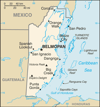
Belize (GPS: 17 15 N, 88 45 W) is located in Central America, bordering the Caribbean Sea, between Guatemala and Mexico. The country’s area measurements are total: 22,966 sq km; land: 22,806 sq km, water: 160 sq km. This sovereign state is slightly smaller than Massachusetts. The total irrigated land is 35 sq km (2012).
One of Belize’s essential features: Only country in Central America without a coastline on the North Pacific Ocean.
It’s significant, and at the same time, the principal city, Belmopan’s GPS coordinates are 17 15 N 88 46 W. Belmopan’s local time is 1 hour behind Washington DC during Standard Time. The capital’s time difference: UTC-6.
For more information on Belize, please scroll down below the Google Maps.
Google Maps Belize and Belmopan, Central America and the Caribbean
About Belize in detail
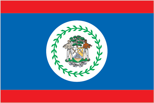
Flag of Belize
Map of Belize
Belize was the site of several Mayan city-states until their decline at the end of the first millennium A.D. The British and Spanish disputed the region in the 17th and 18th centuries; It formally became the British Honduras colony in 1862. Territorial disputes between the UK and Guatemala delayed the independence of Belize until 1981. Guatemala refused to recognize the new nation until 1992, and the two countries are involved in an ongoing border dispute. Both nations have voted to send the dispute for a final resolution to the International Court of Justice. Tourism has become the mainstay of the economy. Current concerns include the country’s heavy foreign debt burden, high crime rates, high unemployment combined with a majority youth population, growing involvement in the Mexican and South American drug trade, and one of the highest HIV/AIDS prevalence rates in Central America.
Belize’s names conventional long form: none, conventional short form: Belize, former: British Honduras, etymology: may be named for the Belize River, whose name possibly derives from the Maya word “belix,” meaning “muddy-watered.” May be named for the Belize River, whose name possibly derives from the Maya word “belix,” meaning “muddy-watered.”
Belize’s terrain is typically flat, swampy coastal plain, low mountains in the south. The country’s mean elevation: 173 m, elevation extremes; lowest point: the Caribbean Sea 0 m, highest point: Doyle’s Delight 1,160 m.
The country’s general climate is tropical: sweltering and humid: rainy season (May to November): the dry season (February to May).
The total number of border countries is 2, Guatemala 266 km, Mexico 276 km are the neighboring nations with the indicated border lengths. Belize’s coastline is 386 km, while its marital claims are: territorial sea: 12 nautical miles in the north, three nautical miles in the south; note – from the mouth of the Sarstoon River to Ranguana Cay, Belize’s territorial sea is three nautical miles; according to Belize’s Maritime Areas Act, 1992, the purpose of this limitation is to provide a framework for negotiating a definitive agreement on territorial differences with Guatemalaexclusive economic zone: 200 nautical miles. Waterways: 825 km (navigable only by small craft) (2011). Land use: agricultural land: 6.9%; arable land 3.3%; permanent crops 1.4%; permanent pasture 2.2%; forest: 60.6%; other: 32.5% (2011 estimate).
The population in Belize 385,854 (July 2018 estimate), urban population: 44% of total population (2015), major urban area’s population: BELMOPAN (capital) 17,000 (2014), while Belize has approximately 25 to 30% of the population lives in the former capital, Belize City; over half of the overall population is rural; population density is slightly higher in the north and east. Their spoken languages are: English 62.9% (official language), Spanish 56.6%, Creole 44.6%, Maya 10.5%, German 3.2%, Garifuna 2.9%, other 1.8%, unknown 0.3%, none 0.2% (cannot speak).
Note shares sum to more than 100% because some respondents gave more than one answer on the census (2010 estimate). Main religions in Belize are Roman Catholic 40.1%, Protestant 31.5% (includes Pentecostal 8.4%, Seventh Day Adventist 5.4%, Anglican 4.7%, Mennonite 3.7%, Baptist 3.6%, Methodist 2.9%, Nazarene 2.8%), Jehovah’s Witness 1.7%, other 10.5% (includes Baha’i, Buddhist, Hindu, Morman, Muslim, Rastafarian), unknown 0.6%, none 15.5% (2010 estimate). The nation uses English common law. It is a(n) parliamentary democracy (National Assembly) under a constitutional monarchy; a Commonwealth realm, National holiday(s) Battle of St. George’s Caye Day (National Day), September 10, 1798; Independence Day, 21 September (1981).
Economic overview for the country: Tourism is the number one foreign exchange earner in this small economy, followed by exports of sugar, bananas, citrus, marine products, and crude oil. The government’s expansionary monetary and fiscal policies, initiated in September 1998, led to GDP growth averaging nearly 4% in 1999-2007, but GPD growth has averaged only 2.1% from 2007-2016, with 2.5% growth estimated for 2017.
Belize’s dependence on energy imports makes it susceptible to energy price shocks. Although Belize has the third-highest per capita income in Central America, the average income figure masks a huge income disparity between rich and poor. A key government objective remains reducing poverty and inequality with the help of international donors. High unemployment, a growing trade deficit, and a massive foreign debt burden continue to be significant concerns. Belize faces continued pressure from rising sovereign debt and a growing trade imbalance.
Natural resources of Belize: arable land potential, timber, fish, hydropower.
Main export partners for Belize, Central America, and the Caribbean are the UK 30.8%, US 18.7%, Nigeria 6.7%, Trinidad and Tobago 4.8%, Ireland 4.2%, Jamaica 4.2% (2015) for sugar, bananas, citrus, clothing, fish products, molasses, wood, crude oil, while the main import partners for the country are: US 26.6%, Mexico 11.7%, Cuba 10.2%, Guatemala 9%, China 7.5%, Trinidad and Tobago 5.6% (2015) for machinery and transport equipment, manufactured goods; fuels, chemicals, pharmaceuticals; food, beverages, tobacco.
When you visit this country in Central America and the Caribbean, consider the natural hazards in Belize: Frequent, devastating hurricanes (June to November) and coastal flooding (especially in the south), while infectious diseases are a degree of risk: high food or waterborne diseases: bacterial diarrhea, hepatitis A, and typhoid fever vectorborne diseases: dengue fever and malaria. Note: active local transmission of Zika virus by Aedes species mosquitoes has been identified in this country (as of August 2016); it poses a substantial risk (a large number of cases possible) among US citizens if bitten by an infective mosquito; other less common ways to get Zika are through sex, via blood transfusion, or during pregnancy, in which the pregnant woman passes Zika virus to her fetus (2016). Also, note that Belize faces the following environmental issues: Deforestation, water pollution, including pollution of Belize’s Barrier Reef System, from sewage, industrial effluents, agricultural runoff, Inability to dispose of solid waste properly.
You may also be interested in the countries next to Belize around its total: 542 km border, like Guatemala, Mexico.