Guatemala (GPS: 15 30 N, 90 15 W) located in Central America, bordering the North Pacific Ocean, between El Salvador and Mexico, and bordering the Gulf of Honduras (Caribbean Sea) between Honduras and Belize. The country’s area measurements are total: 108,889 sq km; land: 107,159 sq km, water: 1,730 sq km. This sovereign state is slightly smaller than Pennsylvania. The total irrigated land is 3,375 sq km (2012).
One of Guatemala’s essential features: Despite having eastern and western coastlines (the Caribbean Sea and the Pacific Ocean, respectively), there are no natural harbors on the west coast. Guatemala is one of the countries along the Ring of Fire, a belt of active volcanoes and earthquake epicenters bordering the Pacific Ocean. Up to 90% of the world’s earthquakes and some 75% of the world’s volcanoes occur within the Ring of Fire.
It’s significant, and at the same time, the principal city, Guatemala City’s GPS coordinates are 14 37 N 90 31 W. Guatemala City’s local time is 1 hour behind Washington DC during Standard Time. The capital’s time difference: UTC-6.
Google Maps Guatemala and Guatemala City, Central America and the Caribbean
About Guatemala in detail
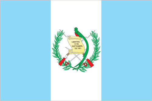
Flag of Guatemala
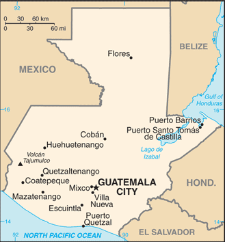
Map of Guatemala
The Maya civilization flourished in Guatemala and surrounding regions during the first millennium A.D. After almost three centuries as a Spanish colony, Guatemala won its independence in 1821. During the second half of the 20th century, it experienced various military and civilian governments and a 36-year guerrilla war. In 1996, the government signed a peace agreement, formally ending the internal conflict.
Guatemala’s names conventional long form: the Republic of Guatemala, conventional short form: Guatemala, local long form: Republica de Guatemala, local short form: Guatemala, etymology: name derives from the Mayan word meaning “land of trees.” The Spanish conquistadors used many native Americans as allies in their conquest of Guatemala; The site of their first capital (established in 1524), a former Maya settlement, was called “Quauhtemallan” by their Nahuatl-speaking Mexican allies, a name that means “land of trees” or “forested land,” but which the Spanish pronounced “Guatemala”; The Spanish applied that name to a re-founded capital city three years later, and eventually it became the name of the country.
Guatemala’s terrain is typically mostly mountains with narrow coastal plains and rolling limestone plateau. The country’s mean elevation: 759 m, elevation extremes; lowest point: Pacific Ocean 0 m, highest point: Volcan Tajumulco 4,211 m.
The general climate in the country; tropical: hot, humid in lowlands: cooler in highlands.
The total number of border countries is 4, Belize 266 km, El Salvador 199 km, Honduras 244 km, Mexico 958 km are the neighboring nations with the indicated border lengths. Guatemala’s coastline is 400 km, while its marital claims are: territorial sea: 12 nautical miles, exclusive economic zone: 200 nautical miles, continental shelf: 200-m depth or to the depth of exploitation. Waterways: 990 km (260 km navigable year-round; additional 730 km navigable during the high-water season) (2012). Land use: agricultural land: 41.2%; arable land 14.2%; permanent crops 8.8%; permanent pasture 18.2%; forest: 33.6%; other: 25.2% (2011 estimate).
The population in Guatemala 16,581,273 (July 2018 estimate), urban population: 51.6% of total population (2015), central metropolitan area’s population: GUATEMALA CITY (capital) 2.918 million (2015), while Guatemala has the vast majority of the populace resides in the southern half of the country, particularly in the mountainous regions; more than half of the population lives in rural areas. Their spoken languages are Spanish (official language) 60%, Amerindian languages 40%.
Note 23 official languages recognized Amerindian languages, including Quiche, Cakchiquel, Kekchi, Mam, Garifuna, and Xinca. The main religions in Guatemala are Roman Catholic, Protestant, indigenous Mayan beliefs. The nation uses civil law system; judicial review of legislative acts. It is a(n) presidential republic, National holiday(s) Independence Day, 15 September (1821).
Economic overview for the country: Guatemala is the most populous country in Central America, with a GDP per capita roughly half the average for Latin America and the Caribbean. The agricultural sector accounts for 13.5% of GDP and 31% of the labor force; key agricultural exports include sugar, coffee, bananas, and vegetables. Guatemala is the top remittance recipient in Central America due to Guatemala’s large expatriate community in the US. These inflows are a primary source of foreign income, equivalent to two-thirds of the country’s exports and about a tenth of its GDP.
The 1996 piece accords, which ended 36 years of civil war, removed a major obstacle to foreign investment, and Guatemala has since pursued important reforms and macroeconomic stabilization. The Dominican Republic-Central America Free Trade Agreement (CAFTA-DR) entered into force in July 2006, spurring increased investment and diversification of exports, with the largest increases in ethanol and non-traditional agricultural exports. While CAFTA-DR has helped improve the investment climate, security concerns, the lack of skilled workers, and poor infrastructure continue to hamper foreign direct investment.
The income distribution remains highly unequal, with the richest 20% of the population accounting for more than 51% of Guatemala’s overall consumption. More than half of the population is below the national poverty line, and 23% live in extreme poverty. Poverty among indigenous groups, which make up more than 40% of the population, averages 79%, with 40% of the indigenous population living in extreme poverty. Nearly one-half of Guatemala’s children under age five are chronically malnourished, one of the world’s highest malnutrition rates.
Main export partners for Guatemala, Central America and the Caribbean are US 34.9%, El Salvador 8.4%, Honduras 7.3%, Nicaragua 5%, Canada 4.6%, Mexico 4.3%, Costa Rica 4.1% (2015) for sugar, coffee, petroleum, apparel, bananas, fruits and vegetables, cardamom, manufacturing products, precious stones and metals, electricity, while the main import partners for the country are: US 38.3%, China 13.4%, Mexico 11.8%, El Salvador 4.9% (2015) for fuels, machinery and transport equipment, construction materials, grain, fertilizers, electricity, mineral products, chemical products, plastic materials and products.
When you visit this country in Central America and the Caribbean, consider the natural hazards in Guatemala: Numerous volcanoes in mountains, with occasional violent earthquakes, Caribbean coast extremely susceptible to hurricanes and other tropical stormsvolcanism: significant volcanic activity in the Sierra Madre range, Santa Maria (elevation 3,772 m) has been deemed a Decade Volcano by the International Association of Volcanology and Chemistry of the Earth’s Interior, worthy of study due to its explosive history and close proximity to human populations, Pacaya (elevation 2,552 m), which erupted in May 2010 causing an ashfall on Guatemala City and prompting evacuations, is one of the country’s most active volcanoes with frequent eruptions since 1965, other historically active volcanoes include Acatenango, Almolonga, Atitlan, Fuego, and Tacana, while infectious diseases are degree of risk: high food or waterborne diseases: bacterial diarrhea, hepatitis A, and typhoid fever vectorborne disease: dengue fever and malaria. Note: active local transmission of Zika virus by Aedes species mosquitoes has been identified in this country (as of August 2016); it poses an important risk (a large number of cases possible) among US citizens if bitten by an infective mosquito; other less common ways to get Zika are through sex, via blood transfusion, or during pregnancy, in which the pregnant woman passes Zika virus to her fetus (2016). Also, note that Guatemala faces the following environmental issues: Deforestation in the Peten rainforest, Soil erosion, water pollution.
You may also be interested in the countries next to Guatemala around its total: 1,667 km border, like Belize, El Salvador, Honduras, Mexico.