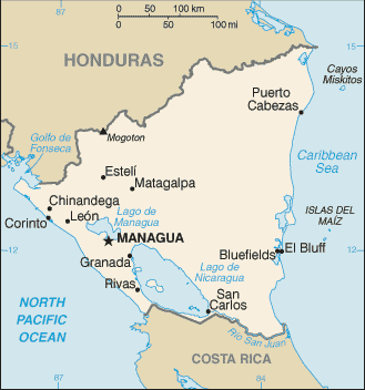
Nicaragua (GPS: 13 00 N, 85 00 W) is located in Central America, bordering both the Caribbean Sea and the North Pacific Ocean, between Costa Rica and Honduras. The country’s area measurements are total: 130,370 sq km; land: 119,990 sq km, water: 10,380 sq km. This sovereign state is slightly larger than Pennsylvania, slightly smaller than New York state. The total irrigated land is 1,990 sq km (2012).
One of the essential features of Nicaragua: Largest country in Central America. Contains the largest freshwater body in Central America, Lago de Nicaragua.
It’s significant, and at the same time, the principal city, Managua’s GPS coordinates are 12 08 N 86 15 W. Managua’s local time is 1 hour behind Washington DC during Standard Time. The capital’s time difference: UTC-6.
Google Maps Nicaragua and Managua, Central America and the Caribbean
About Nicaragua in detail
Flag of Nicaragua
Map of Nicaragua
The Pacific coast of Nicaragua was settled as a Spanish colony from Panama in the early 16th century. Independence from Spain declared in 1821, and the country became an independent republic in 1838. Britain occupied the Caribbean Coast in the first half of the 19th century but gradually ceded control of the region in subsequent decades. Violent opposition to governmental manipulation and corruption spread to all classes by 1978. It resulted in a short-lived civil war that brought a civic-military coalition, spearheaded by the Marxist Sandinista guerrillas led by Daniel ORTEGA Saavedra to power in 1979.
Nicaraguan aid to leftist rebels in El Salvador prompted the US to sponsor anti-Sandinista contra guerrillas through much of the 1980s. After losing free and fair elections in 1990, 1996, and 2001, former Sandinista President Daniel ORTEGA was elected president in 2006, 2011, and most recently in 2016. Widespread irregularities have marred municipal, regional, and national-level elections since 2008. Democratic institutions have weakened under the ORTEGA administration as the president has garnered full control over all government branches, especially after cracking down on a nationwide anti-government protest movement in 2018.
Nicaragua’s names conventional long form: the Republic of Nicaragua, traditional short form: Nicaragua, local long form: Republica de Nicaragua, local short state: Nicaragua, etymology: Nicarao was the name of the largest indigenous settlement at the time of Spanish arrival; conquistador Gil GONZALEZ Davila, who explored the area (1622-23), combined the name of the community with the Spanish word “agua” (water), referring to the two large lakes in the west of the country (Lake Managua and Lake Nicaragua). Nicarao was the name of the largest indigenous settlement at the time of Spanish arrival; Conquistador Gil GONZALEZ Davila, who explored the area (1622-23), combined the name of the community with the Spanish word “agua” (water), referring to the two large lakes in the west of the country (Lake Managua and Lake Nicaragua).
Nicaragua’s terrain is typically extensive Atlantic coastal plains rising to central interior mountains; narrow Pacific coastal plain interrupted by volcanoes. The country’s mean elevation: 298 m, elevation extremes; lowest point: Pacific Ocean 0 m, highest point: Mogoton 2,438 m.
The general climate in the country; tropical in the lowlands, more relaxed in the highlands.
The total number of border countries is 2, Costa Rica 313 km, Honduras 940 km are the neighboring nations with the indicated border lengths. Nicaragua’s coastline is 910 km, while its marital claims are: territorial sea: 12 nautical miles, contiguous zone: 24 nautical miles, continental shelf: natural prolongation. Waterways: 2,220 km (navigable waterways and the use of the large Lake Managua and Lake Nicaragua; rivers serve only the sparsely populated eastern part of the country) (2011). Land use: agricultural land: 42.2%; arable land 12.5%; permanent crops 2.5%; permanent pasture 27.2%; forest: 25.3%; other: 32.5% (2011 estimate).
The population in Nicaragua 6,085,213 (July 2018 estimate), urban population: 58.8% of total population (2015), central metropolitan area’s population: MANAGUA (capital) 956,000 (2015), while Nicaragua has the overwhelming majority of the population resides in the western half of the country, with much of the urban growth centered in the capital city of Managua; coastal areas also show large population clusters.
Their spoken languages are Spanish (official language) 95.3%, Miskito 2.2%, Mestizo of the Caribbean coast 2%, other 0.5%. Note: English and indigenous languages found on the Caribbean coast (2005 estimate). Main religions in Nicaragua are Roman Catholic 58.5%, Protestant 23.2% (Evangelical 21.6%, Moravian 1.6%), Jehovah’s Witnesses 0.9%, other 1.6%, none 15.7% (2005 estimate). The nation uses civil law system; the Supreme Court may review administrative acts. It is a(n) presidential republic, National holiday(s) Independence Day, 15 September (1821).
Economic overview for the country: Nicaragua, the poorest country in Central America and the second poorest in the Western Hemisphere, has widespread underemployment and poverty. GDP growth of 4.5% in 2017 was insufficient to make a significant difference. Textiles and agriculture combined account for nearly 50% of Nicaragua’s exports. Beef, coffee, and gold are Nicaragua’s top three export commodities. The Dominican Republic-Central America-United States Free Trade Agreement has been in effect since April 2006 and has expanded export opportunities for many Nicaraguan agricultural and manufactured goods. In 2013, the government granted a 50-year concession with the option for an additional 50 years to a newly formed Chinese-run company to finance and build an inter-oceanic canal and related projects, at an estimated cost of 50 billion. The canal construction has not started.
Main export partners for Nicaragua, Central America, and the Caribbean are US 56.5%, Mexico 10.7%, Venezuela 5.4%, El Salvador 4.3% (2015) for coffee, beef, gold, sugar, peanuts, shrimp and lobster, tobacco, cigars, automobile wiring harnesses, textiles, apparel, cotton, while the main import partners for the country are: US 19.9%, Mexico 14.9%, China 10.6%, Venezuela 7%, Costa Rica 7%, El Salvador 5.7%, Guatemala 5.6%, Netherlands Antilles 5.5% (2015) for consumer goods, machinery, and equipment, raw materials, petroleum products.
When you visit this country in Central America and the Caribbean, consider the natural hazards in Nicaragua: Destructive earthquakes, volcanoes, landslides, extremely susceptible to hurricanesvolcanism: significant volcanic activity, Cerro Negro (elevation 728 m), which last erupted in 1999, is one of Nicaragua’s most active volcanoes, its lava flows and ash have been known to cause significant damage to farmland and buildings, other historically active volcanoes include Concepcion, Cosiguina, Las Pilas, Masaya, Momotombo, San Cristobal, and Telica, while infectious diseases are degree of risk: high food or waterborne diseases: bacterial diarrhea, hepatitis A, and typhoid fever vectorborne disease: dengue fever and malaria.
Note: active local transmission of Zika virus by Aedes species mosquitoes has been identified in this country (as of August 2016); it poses a substantial risk (a large number of cases possible) among US citizens if bitten by an infective mosquito; other less common ways to get Zika are through sex, via blood transfusion, or during pregnancy, in which the pregnant woman passes Zika virus to her fetus (2016). Also, note that Nicaragua faces the following environmental issues: Deforestation, Soil erosion, water pollution, Drought.
You may also be interested in the countries next to Nicaragua around its total: 1,253 km border, like Costa Rica, Honduras.