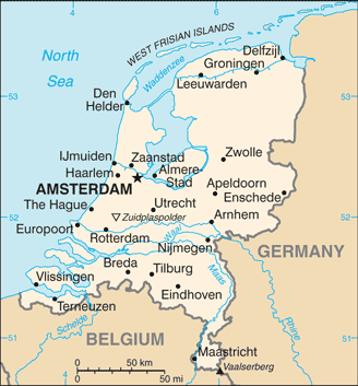
Netherlands (GPS: 52 30 N, 5 45 E) located in Western Europe, bordering the North Sea, between Belgium and Germany. The country’s area measurements are total: 41,543 sq km; land: 33,893 sq km, water: 7,650 sq km. This sovereign state is slightly less than twice the size of New Jersey. The total irrigated land is 4,860 sq km (2012).
One of the Netherlands’ important features: Located at the mouths of three major European rivers (the Rhine, Maas or Meuse, and Schelde). About a quarter of the country lies below sea-level, and only about half of the land exceeds one meter above sea-level.
It’s significant, and at the same time, the principal city, Amsterdam’s GPS coordinates are 52 21 N 4 55 E. Amsterdam’s local time is 6 hours ahead of Washington DC during Standard Time. The capital’s time difference: UTC+1, note; Daylight saving time: +1hr begins last Sunday in March; ends last Sunday in October. Note: time descriptions apply to the continental Netherlands only, not to the Caribbean components.
The Dutch United Provinces declared their independence from Spain in 1579; During the 17th century, they became a leading seafaring and commercial power, with settlements and colonies worldwide. After a 20-year French occupation, the Kingdom of the Netherlands formed in 1815. In 1830, Belgium seceded and formed a separate kingdom. The Netherlands remained neutral in World War I but suffered German invasion and occupation in World War II. A modern, industrialized nation, the Netherlands is also a large exporter of agricultural products.
The country was a founding member of NATO and the EEC (now the EU) and participated in introducing the euro in 1999. In October 2010, the former Netherlands Antilles dissolved, and the three smallest islands – Bonaire, Sint Eustatius, and Saba – became special municipalities in the Netherlands administrative structure. The larger islands of Sint Maarten and Curacao joined the Netherlands and Aruba as constituent countries forming the Kingdom of the Netherlands. In February 2018, the Sint Eustatius island council (governing body) dissolved and replaced by a government commissioner to restore public administration integrity. According to the Dutch Government, the intervention will be as “short as possible and as long as needed.”
Netherlands’s names conventional long form: Kingdom of the Netherlands, conventional short form: Netherlands, local long form: Koninkrijk der Nederlanden, local short state: Nederland, etymology: the country name means “the lowlands” and refers to the geographic features of the land being both flat and downriver from higher areas (i.e., at the estuaries of the Scheldt, Meuse, and Rhine Rivers; only about half of the Netherlands is more than 1 meter above sea-level). The country name means “the lowlands” and refers to the geographic features of the land being both flat and downriver from higher areas (i.e., at the estuaries of the Scheldt, Meuse, and Rhine Rivers; Only about half of the Netherlands is more than 1 meter above sea-level).
Netherlands’s terrain is typically mostly coastal lowland and reclaimed land (polders); some hills in the southeast. The country’s mean elevation: 30 m, elevation extremes; lowest point: Zuidplaspolder -7 m, highest point: Mount Scenery 862 m.
The general climate in the country; temperate: marine: cool summers and mild winters.
The total number of border countries is 2, Belgium 478 km, Germany 575 km are the neighboring nations with the indicated border lengths. Netherlands’s coastline is 451 km, while its marital claims are: territorial sea: 12 nautical miles, contiguous zone: 24 nautical miles, exclusive fishing zone: 200 nautical miles. Waterways: 6,237 km (navigable by ships up to 50 tons) (2012). Land use: agricultural land: 55.1%; arable land 29.8%; permanent crops 1.1%; permanent pasture 24.2%; forest: 10.8%; other: 34.1% (2011 estimate).
The population in Netherlands 17,151,228 (July 2018 estimate), urban population: 90.5% of total population (2015), central urban area’s population: AMSTERDAM (capital) 1.091 million; Rotterdam 993,000; The Hague (seat of government) 650,000 (2015), while the Netherlands has an area known as the Randstad, anchored by the cities of Amsterdam, Rotterdam, the Hague, and Utrecht, is the most densely populated region; the north tends to be less dense, though sizeable communities can be found throughout the entire country. Their spoken languages are Dutch (official language).
Note: Frisian is an official language in Fryslan province; Frisian, Low Saxon, Limburgish, Romani, and Yiddish have protected status under the European Charter for Regional or Minority Languages; Dutch is the official language of the three special municipalities of the Caribbean Netherlands, while English is a recognized regional language on Sint Eustatius and Saba and Papiamento is a recognized local language on Bonaire. Main religions in the Netherlands are Roman Catholic 28%, Protestant 19% (includes Dutch Reformed 9%, Protestant Church of The Netherlands, 7%, Calvinist 3%), other 11% (includes about 5% Muslim and fewer numbers of Hindu, Buddhist, Jehovah’s Witness, and Orthodox), none 42% (2009 estimate). The nation uses civil law system based on the French system; the constitution does not permit judicial review of the States-General acts. It is a(n) parliamentary constitutional monarchy; part of the Kingdom of the Netherlands, National holiday(s) King’s Day (the King’s birthday of 27 April (1967); celebrated on 26 April if 27 April is a Sunday).
Economic overview for the country: The Netherlands, the sixth-largest economy in the European Union, plays a vital role as a European transportation hub, with a consistently high trade surplus, stable industrial relations, and low unemployment. Industry focuses on food processing, chemicals, petroleum refining, and electrical machinery. A highly mechanized agricultural sector employs only 2% of the labor force but provides large surpluses for food-processing and underpins its status as the world’s second-largest agricultural exporter.
The Netherlands is part of the eurozone, and as such, its monetary policy is controlled by the European Central Bank. The Dutch financial sector is highly concentrated, with four commercial banks possessing over 80% of banking assets, and is four times the Dutch GDP size. In 2008, during the financial crisis, the government budget deficit hit 5.3% of GDP. Following a protracted recession from 2009 to 2013, during which unemployment doubled to 7.4%, and household consumption contracted for four consecutive years, economic growth began inching forward in 2014.
Since 2010, Prime Minister Mark RUTTE’s government has implemented significant austerity measures to improve public finances. It has instituted broad structural reforms in key policy areas, including the labor market, the housing sector, the energy market, and the pension system. In 2017, the government budget returned to a surplus of 0.7% of GDP, with economic growth of 3.2%, and GDP per capita finally surpassed pre-crisis levels. The new government announced the fiscal policy in the 2018-2021 coalition plans for increases in government consumption and public investment, fueling domestic demand and household consumption and investment. The new government’s policy also plans to increase demand for workers in the public and private sectors, forecasting a further decline in the unemployment rate, which hit 4.8% in 2017.
Natural resources of Netherlands: natural gas, petroleum, peat, limestone, salt, sand and gravel, arable land.
Main export partners for the Netherlands, Europe are Germany 24.5%, Belgium 11.1%, UK 9.3%, France 8.4%, Italy 4.2% (2015) for machinery and equipment, chemicals, fuels; foodstuffs, while the main import partners for the country are: Germany 14.7%, China 14.5%, Belgium 8.2%, US 8.1%, UK 5.1% (2015) for machinery and transport equipment, chemicals, fuels, foodstuffs, clothing.
When you visit this country in Europe, consider the natural hazards in the Netherlands: Flooding, while infectious diseases are N/A. Also, note that the Netherlands faces the following environmental issues: Water and air pollution are significant environmental problems, Pollution of the country’s rivers from industrial and agricultural chemicals, including heavy metals, organic compounds, nitrates, and phosphates, Air pollution from vehicles and refining activities.
You may also be interested in the countries next to the Netherlands around its total: 1,053 km border, like Belgium, Germany.