Aruba (GPS: 12 30 N, 69 58 W) is located in the Caribbean, an island in the Caribbean Sea, north of Venezuela. The country’s area measurements are total: 180 sq km; land: 180 sq km, water: 0 sq km. This sovereign state is slightly larger than Washington, DC. The total irrigated land is N/A.
One of the essential features of Aruba: A flat, riverless island renowned for its white-sand beaches. Its tropical climate is moderated by constant trade winds from the Atlantic Ocean. The temperature is almost constant at about 27 degrees Celsius (81 degrees Fahrenheit).
It’s significant, and at the same time, the principal city, Oranjestad’s GPS coordinates are 12 31 N 70 02 W. Oranjestad’s local time is 1 hour ahead of Washington DC during Standard Time. The capital’s time difference: UTC-4.
For more information on Aruba, please scroll down below the Google Maps.
Google Maps Aruba and Oranjestad, Central America and the Caribbean
About Aruba in detail
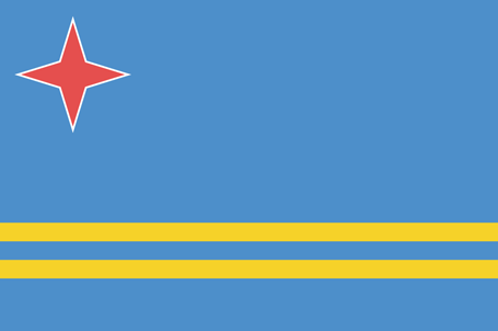
Flag of Aruba
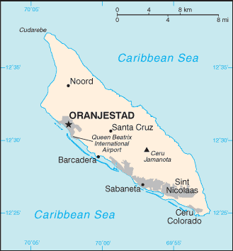
Map of Aruba
Discovered and claimed for Spain in 1499, Aruba was acquired by the Dutch in 1636. Three main industries have dominated the island’s economy. A 19th-century gold rush was followed by prosperity brought on by the opening in 1924 of an oil refinery. The last decades of the 20th century saw a boom in the tourism industry. Aruba seceded from the Netherlands Antilles in 1986 and became a separate, semi-autonomous member of the Kingdom of the Netherlands. A movement toward full independence was halted at Aruba’s request in 1990.
Aruba’s names conventional long form: none, traditional short form: Aruba, etymology: the origin of the island’s name is unclear; according to tradition, the name comes from the Spanish phrase “oro huba” (there was gold), but in fact, no gold was ever found on the island; another possibility is the native word “oruba,” which means “well situated.” The origin of the island’s name is unclear; According to tradition, the name comes from the Spanish phrase “oro huba” (there was gold), but in fact, no gold was ever found on the island; Another possibility is the native word “oruba,” which means “well-situated.”
Aruba’s terrain is typically flat with a few hills; scant vegetation. The country’s mean elevation: N/A, elevation extremes; lowest point: the Caribbean Sea 0 m, highest point: Ceru Jamanota 188 m.
The general climate in the country; tropical marine: little seasonal temperature variation.
The total number of border countries is 0; none are the neighboring nations with the indicated border lengths. Aruba’s coastline is 68.5 km, while its marital claims are: territorial sea: 12 nautical miles. Waterways: N/A. Land use: agricultural land: 11.1%; arable land 11.1%; permanent crops 0%; permanent pasture 0%; forest: 2.3%; other: 86.6% (2011 estimate).
The population in Aruba 116,576 (July 2018 estimate), urban population: 41.5% of total population (2015), major urban area’s population: ORANJESTAD (capital) 29,000 (2014), while Aruba has most residents live in or around Oranjestad and San Nicolaas; most settlements tend to be located on the less mountainous western side of the island. Their spoken languages are: Papiamento (official language) (a creole language that is a mixture of Portuguese, Spanish, Dutch, English, and, to a lesser extent, French, as well as elements of African languages and the language of the Arawak) 69.4%, Spanish 13.7%, English (widely spoken) 7.1%, Dutch (official language) 6.1%, Chinese 1.5%, other 1.7%, unspecified 0.4% (2010 estimate). Main religions in Aruba are Roman Catholic 75.3%, Protestant 4.9% (includes Methodist 0.9%, Adventist 0.9%, Anglican 0.4%, other Protestant 2.7%), Jehovah’s Witness 1.7%, other 12%, none 5.5%, unspecified 0.5% (2010 estimate). The nation uses a civil law system based on the Dutch civil code. It is a(n) parliamentary democracy (Legislature); part of the Kingdom of the Netherlands, National holiday(s) Flag Day, 18 March (1976).
Economic overview for the country: Tourism, petroleum bunkering, hospitality, and financial and business services are the mainstays of the small open Aruban economy. Tourism accounts for most economic activity; As of 2017, over 2 million tourists visited Aruba annually, with the large majority (80-85%) of those from the US. The rapid growth of the tourism sector has resulted in a substantial expansion of other activities. Construction continues to boom, especially in the hospitality sector. Aruba is heavily dependent on imports and is making efforts to expand exports to improve its trade balance.
Almost all consumer and capital goods are imported, with the US, the Netherlands, and Panama being the major suppliers. In 2016, Citgo Petroleum Corporation, an indirect wholly-owned subsidiary of Petroleos de Venezuela SA, and the Government of Aruba signed an agreement to restart Valero Energy Corp.’s former 235,000-b/d refinery. Tourism and related industries have continued to grow, and the Aruban Government is working to attract more diverse industries. Aruba’s banking sector continues to be healthy; unemployment has significantly decreased.
Natural resources of Aruba: NEGL; white sandy beaches foster tourism.
Main export partners for Aruba, Central America, and the Caribbean are Colombia 28.2%, Netherlands Antilles 18.1%, US 14.3%, Netherlands 10.1%, Mexico 6.5%, Venezuela 6.3%, Panama 4.1% (2015) for live animals and animal products, art and collectibles, machinery and electrical equipment, transport equipment, while the main import partners for the country are: the US 55.4%, Netherlands 11.2% (2015) for machinery and electrical equipment, refined oil for bunkering and re-export, chemicals; foodstuffs.
When you visit this country in Central America and the Caribbean, consider the natural hazards in Aruba: Hurricanes lies outside the Caribbean hurricane belt and is rarely threatened, while infectious diseases are noted: active local transmission of Zika virus by Aedes species mosquitoes has been identified in this country (as of August 2016); it poses a critical risk (a large number of cases possible) among US citizens if bitten by an infective mosquito; other less common ways to get Zika are through sex, via blood transfusion, or during pregnancy, in which the pregnant woman passes Zika virus to her fetus (2016). Also, note that Aruba faces the following environmental issues: Difficulty in properly disposing of waste produced by large numbers of tourists, waste burning in the landfill causes air pollution and poses an environmental and health risk, Ocean ecological damage due to plastic pollution.
You may also be interested in the countries next to Aruba around its 0 km border – No border countries.