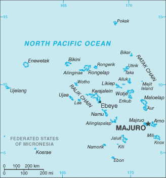
Marshall Islands (GPS: 9 00 N, 168 00 E) located in Oceania, two archipelagic island chains of 29 atolls, each made up of many small islets, and five single islands in the North Pacific Ocean, about halfway between Hawaii and Australia. The country’s area measurements are total: 181 sq km; land: 181 sq km, water: 0 sq km. This sovereign state is about the size of Washington, DC. The total irrigated land is 0 sq km (2012).
One of the essential features of the Marshall Islands: The islands of Bikini and Enewetak are former US nuclear test sites. Kwajalein atoll, famous as a World War II battleground, surrounds the world’s largest lagoon and is used as a US missile test range. Ebeye’s island city is the second-largest settlement in the Marshall Islands, after the capital of Majuro, and one of the most densely populated locations in the Pacific.
It’s significant, and at the same time, the principal city, Majuro’s GPS coordinates are 7 06 N 171 23 E. Majuro’s local time is 17 hours ahead of Washington DC during Standard Time. The capital’s time difference: UTC+12.
After almost four decades under US administration as the easternmost part of the UN Trust Territory of the Pacific Islands, the Marshall Islands attained independence in 1986 under a Compact of Free Association. Compensation claims continue due to US nuclear testing conducted on some of the atolls between 1947 and 1962 (67 tests total). The Marshall Islands hosts the US Army Kwajalein Atoll Reagan Missile Test Site, a key installation in the US missile defense network. Kwajalein also hosts one of four dedicated ground antennas that assist in the operation of the Global Positioning System (GPS) navigation system (the others are at Cape Canaveral, Florida (US), on Ascension (Saint Helena, Ascension, and Tristan da Cunha), and at Diego Garcia (British Indian Ocean Territory)).
Marshall Islands’s names conventional long form: the Republic of the Marshall Islands, conventional short form: Marshall Islands, local long form: the Republic of the Marshall Islands, local short form: Marshall Islands abbreviation: RMI, former: Trust Territory of the Pacific Islands, Marshall Islands District, etymology: named after British Captain John MARSHALL, who charted many of the islands in 1788. Named after British Captain John MARSHALL, who charted many of the islands in 1788.
Marshall Islands’ terrain is typically low coral limestone and sand islands. The country’s mean elevation: N/A, elevation extremes; lowest point: Pacific Ocean 0 m, highest point: unnamed location on Likiep 10 m.
The country’s general climate is tropical: hot and humid: wet season May to November: islands border typhoon belt.
The total number of border countries is 0; none are the neighboring nations with the indicated border lengths. Marshall Islands’s coastline is 370.4 km, while its marital claims are: territorial sea: 12 nautical miles, contiguous zone: 24 nautical miles, exclusive economic zone: 200 nautical miles. Waterways: N/A. Land use: agricultural land: 50.7%; arable land 7.8%; permanent crops 31.2%; permanent pasture 11.7%; forest: 49.3%; other: 0% (2011 estimate).
The population in Marshall Islands 75,684 (July 2018 estimate), urban population: 72.7% of total population (2015), central metropolitan area’s population: MAJURO (capital) 31,000 (2014), while Marshall Islands has N/A. Their spoken languages are Marshallese (official language) 98.2%, other languages 1.8% (1999 census). Note English (official language), widely spoken as a second language. Main religions in the Marshall Islands are Protestant 54.8%, Assembly of God 25.8%, Roman Catholic 8.4%, Bukot nan Jesus 2.8%, Mormon 2.1%, other Christian 3.6%, additional 1%, none 1.5% (1999 census). The nation uses a mixed legal system of US and English common law, customary law, and local statutes. It is a(n) presidential republic in free association with the US, National holiday(s) Constitution Day, 1 May (1979).
Economic overview for the country: US assistance and lease payments for the use of Kwajalein Atoll as a US military base are the mainstays of this small island country. Agricultural production, primarily subsistence, is concentrated on small farms; The most important commercial crops are coconuts and breadfruit. The industry is limited to handicrafts, tuna processing, and copra. Tourism holds some potential. The islands and atolls have few natural resources, and imports exceed exports. The Marshall Islands received roughly $1 billion in aid from the US during 1986-2001 under the original Compact of Free Association (Compact). In 2002 and 2003, the US and the Marshall Islands renegotiated the Compact’s financial package for 20 years, 2004 to 2024. Under the amended Compact, the Marshall Islands will receive roughly $1.5 billion in direct US assistance. Under the amended Compact, the US and the Marshall Islands are also jointly funding a Trust Fund for the Marshall Islands people to provide an income stream beyond 2024, when Compact direct aid ends.
Natural resources of Marshall Islands: coconut products, marine products, deep seabed minerals.
Main export partners for the Marshall Islands, Oceania are N/A for copra cake, coconut oil, handicrafts, fish, while the main import partners for the country are: N/A for foodstuffs, machinery, and equipment, fuels, beverages, tobacco.
When you visit this country in Oceania, consider the natural hazards in the Marshall Islands: Infrequent typhoons, while infectious diseases are noted: active local transmission of Zika virus by Aedes species mosquitoes have been identified in this country (as of August 2016); it poses a significant risk (a large number of cases possible) among US citizens if bitten by an infective mosquito; other less common ways to get Zika are through sex, via blood transfusion, or during pregnancy, in which the pregnant woman passes Zika virus to her fetus (2016). Also, note that the Marshall Islands faces the following environmental issues: Inadequate supplies of potable water, Pollution of Majuro lagoon from household waste and discharges from fishing vessels, Sea level rise.
You may also be interested in the countries next to the Marshall Islands around its 0 km border – No border countries.