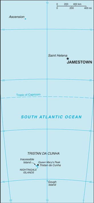
Saint Helena, Ascension, and Tristan da Cunha (GPS: 15 57 S, 5 42 W) located in islands in the South Atlantic Ocean, about midway between South America and Africa; Ascension Island lies 1,300 km (800 mi) northwest of Saint Helena; Tristan da Cunha lies 4,300 km (2,700 mi) southwest of Saint Helena. The country’s area measurements are total: 308 sq km; land: 308 sq km, water: 0 sq km. This sovereign state is slightly more than twice the size of Washington, DC. The total irrigated land is 0 sq km (2012).
One of the crucial features of Saint Helena, Ascension, and Tristan da Cunha: Saint Helena harbors at least 40 species of plants unknown elsewhere in the world. Ascension is a breeding ground for sea turtles and sooty terns. Queen Mary’s Peak on Tristan da Cunha is the highest island mountain in the South Atlantic and a prominent landmark on the sea lanes around southern Africa.
It’s significant, and at the same time, the principal city, Jamestown’s GPS coordinates are 15 56 S 5 43 W. Jamestown’s local time is 5 hours ahead of Washington DC during Standard Time. The capital’s time difference: UTC 0.
Google Maps Saint Helena, Ascension, and Tristan da Cunha and Jamestown, Africa
About Saint Helena, Ascension, and Tristan da Cunha in detail
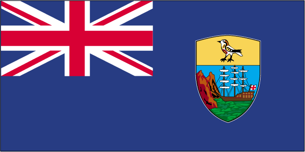
Flag of Saint Helena, Ascension, and Tristan da Cunha
Map of Saint Helena, Ascension, and Tristan da Cunha
Saint Helena is a British Overseas Territory consisting of Saint Helena and Ascension Islands and Tristan da Cunha’s island group.
Saint Helena: Uninhabited when first discovered by the Portuguese in 1502, Saint Helena was garrisoned by the British during the 17th century. It acquired fame as the place of Napoleon BONAPARTE’s exile from 1815 until he died in 1821, but its importance as a port of call declined after the Suez Canal opening in 1869. During the Anglo-Boer War in South Africa, several thousand Boer prisoners were confined on the island between 1900 and 1903. Saint Helena is one of the most remote populated places in the world. The British Government committed to building an airport on Saint Helena in 2005. After more than a decade of delays and construction, commercial air service to South Africa via Namibia was inaugurated in October of 2017. The weekly service to Saint Helena from Johannesburg via Windhoek in Namibia takes just over six hours (including the refueling stop in Windhoek). It replaces the mail ship that had made a five-day journey to the island every three weeks.
Ascension Island: This barren and uninhabited island was discovered and named by the Portuguese in 1503. The British garrisoned the island in 1815 to prevent a rescue of Napoleon from Saint Helena. It served as a provisioning station for the Royal Navy’s West Africa Squadron on anti-slavery patrol. The island remained under Admiralty control until 1922 when it became a dependency of Saint Helena. During World War II, the UK permitted the US to construct an airfield on Ascension to support transatlantic flights to Africa and anti-submarine operations in the South Atlantic. In the 1960s, the island became an important space tracking station for the US. In 1982, Ascension was an important staging area for British forces during the Falklands War. It remains a critical refueling point in the air-bridge from the UK to the South Atlantic.; The island hosts one of four dedicated ground antennas that assist in the operation of the Global Positioning System (GPS) navigation system (the others are on Diego Garcia (British Indian Ocean Territory), Kwajalein (Marshall Islands), and at Cape Canaveral, Florida (US)). NASA and the US Air Force also operate a Meter-Class Autonomous Telescope (MCAT) on Ascension as part of the deep space surveillance system for tracking orbital debris, which can be a hazard to spacecraft and astronauts.
Tristan da Cunha: The island group consists of Tristan da Cunha, Nightingale, Inaccessible, and Gough Islands. Tristan da Cunha, named after its Portuguese discoverer (1506), was garrisoned by the British in 1816 to prevent any attempt to rescue Napoleon from Saint Helena. Gough and Inaccessible Islands have been designated World Heritage Sites. South Africa leases a site for a meteorological station on Gough Island.
Saint Helena, Ascension, and Tristan da Cunha’s names conventional long form: Saint Helena, Ascension, and Tristan da Cunha, conventional short form: none, etymology: Saint Helena was discovered in 1502 by Galician navigator Joao da NOVA, sailing in the service of the Kingdom of Portugal, who named it “Santa Helena”; Ascension was named in 1503 by Portuguese navigator Afonso de ALBUQUERQUE who sighted the island on the Feast Day of the Ascension; Tristan da Cunha was discovered in 1506 by Portuguese explorer Tristao da CUNHA who christened the main island after himself (the name was subsequently anglicized).
Saint Helena, Ascension, and Tristan da Cunha’s terrain are volcanic origin associated with the Atlantic Mid-Ocean RidgeSaint Helena: rugged, volcanic; small scattered plateaus and plainsAscension: surface covered by lava flows and cinder cones of 44 dormant volcanoes; terrain rises to the eastTristan da Cunha: sheer cliffs line the coastline of the nearly circular island; the flanks of the central volcanic peak are deeply dissected; narrow coastal plain lies between The Peak and the coastal cliffs. The country’s mean elevation: N/A, elevation extremes; lowest point: Atlantic Ocean 0 m, highest point: Queen Mary’s Peak on Tristan da Cunha 2,060 m.
The country’s general climate is Saint Helena: tropical marine: mild, tempered by trade windsAscension Island: tropical marine: mild, semi-arid. Tristan da Cunha: temperate marine: mild, tempered by trade winds (tends to be cooler than Saint Helena).
The total number of border countries is 0; none are the neighboring nations with the indicated border lengths. Saint Helena, Ascension, and Tristan da Cunha’s coastline is Saint Helena: 60 kmAscension Island: NA. Tristan da Cunha: 40 km. Its marital claims are territorial sea: 12 nautical miles, exclusive fishing zone: 200 nautical miles. Waterways: N/A. Land use: agricultural land: 30.8%; arable land 10.3%; permanent crops 0%; permanent pasture 20.5%; forest: 5.1%; other: 64.1% (2011 estimate).
The population in Saint Helena, Ascension, and Tristan da Cunha 7,841 (July 2018 estimate), urban population: 39.4% of total population (2015), major urban area’s population: JAMESTOWN (capital) 1,000 (2014), while Saint Helena, Ascension, and Tristan da Cunha have N/A. Their spoken languages are English. Main religions in Saint Helena, Ascension, and Tristan da Cunha are Protestant 75.9% (includes Anglican 68.9, Baptist 2.1%, Seventh Day Adventist 1.8%, Salvation Army 1.7%, New Apostolic 1.4%), Jehovah’s Witness 4.1%, Roman Catholic 1.2%, other 2.5% (includes Baha’i), unspecified 0.8%, none 6.1%, no response 9.4%note: data represent Saint Helena only (2016 estimate). The nation uses English common law and local statutes. It is a(n) parliamentary democracy (Legislative Council); limited self-governing overseas territory of the UK, National holiday(s) Birthday of Queen ELIZABETH II, third Monday in April (1926).
Economic overview for the country: The economy depends largely on financial assistance from the UK, which amounted to about $27 million in FY06/07 or more than twice the annual budgetary revenues level. The local population earns income from fishing, raising livestock, and sales of handicrafts. Because there are few jobs, 25% of the workforce has left to seek employment on Ascension Island, the Falklands, and the UK.
Natural resources of Saint Helena, Ascension, and Tristan da Cunha: fish, lobster.
Main export partners for Saint Helena, Ascension, and Tristan da Cunha, Africa are N/A for fish (frozen, canned, and salt-dried skipjack, tuna), coffee, handicrafts, while the main import partners for the country are: N/A for food, beverages, tobacco, fuel oils, animal feed, building materials, motor vehicles and parts, machinery and parts.
When you visit this country in Africa, consider the natural hazards in Saint Helena, Ascension, and Tristan da Cunha: Active volcanism on Tristan da Cunhavolcanism: the island volcanoes of Tristan da Cunha (elevation 2,060 m) and Nightingale Island (elevation 365 m) experience volcanic activity, Tristan da Cunha erupted in 1962 and Nightingale in 2004, while infectious diseases are N/A. Also, note that Saint Helena, Ascension, and Tristan da Cunha faces the following environmental issues: Development threatens the unique biota on Saint Helena.
You may also be interested in the countries next to Saint Helena, Ascension, and Tristan da Cunha around its 0 km border – No border countries.