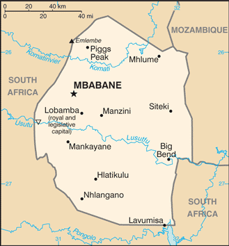
Eswatini (GPS: 26 30 S, 31 30 E) is located in Southern Africa, between Mozambique and South Africa. The country’s area measurements are total: 17,364 sq km; land: 17,204 sq km, water: 160 sq km. This sovereign state is slightly smaller than New Jersey. The total irrigated land is 500 sq km (2012).
One of the important features of Eswatini: Landlocked (enclosed or nearly enclosed by land). Almost surrounded by South Africa.
It’s significant, and at the same time, the principal city, Mbabane’s GPS coordinates are 26 19 S 31 08 E. Mbabane’s local time is 7 hours ahead of Washington DC during Standard Time. The capital’s time difference: UTC+2.
The British’s autonomy for Eswatini was guaranteed in the late 19th century; Independence was granted in 1968. A new constitution came into effect in 2006, which included provisions for a more independent parliament and judiciary, but political parties’ legal status remains unclear. King MSWATI III renamed the country from Swaziland to Eswatini in April 2018. Despite its classification as a lower-middle-income country, Eswatini has one of the lowest GDP growth rates in Sub-Saharan Africa and suffers from severe poverty and high unemployment. Eswatini has the world’s highest known HIV/AIDS prevalence rate, although recent years have shown marked declines in new infections.
Eswatini’s names conventional long form: the Kingdom of Eswatini, traditional short form: Eswatini, local extended state: Umbuso we Swatini, local short form: eSwatini, etymology: “Land of the Swazi” people; the name “Swazi” derives from 19th century King MSWATI II, under whose rule Swazi territory was expanded and unified.
Eswatini’s terrain is typically mostly mountains and hills, some moderately sloping plains. The country’s mean elevation: 305 m, elevation extremes; lowest point: Great Usutu River 21 m, highest point: Emlembe 1,862 m.
The general climate in the country; varies from tropical to near temperate.
The total number of border countries is 2, Mozambique 108 km, South Africa 438 km are the neighboring nations with the indicated border lengths. Eswatini’s coastline is 0 km (landlocked country), while its marital claims are: none. Waterways: N/A. Land use: agricultural land: 68.3%; arable land 9.8%; permanent crops 0.8%; permanent pasture 57.7%; forest: 31.7%; other: 0% (2011 estimate).
The population in Eswatini 1,087,200 (July 2018 estimate), urban population: 21.3% of total population (2015), major urban area’s population: MBABANE (capital) 66,000 (2014), while Eswatini has N/A. Their spoken languages are English (official language, used for government business), siSwati (official language). Main religions in Eswatini are Zionist 40% (a blend of Christianity and indigenous ancestral worship), Roman Catholic 20%, Muslim 10%, other 30% (includes Anglican, Baha’i, Methodist, Mormon, Jewish). The nation uses a mixed legal system of civil, common, and customary law. It is a(n) absolute monarchy, National holiday(s) Independence Day, 6 September (1968).
Economic overview for the country: A small, landlocked kingdom, Eswatini is bordered in the north, west, and south by the Republic of South Africa and Mozambique in the east. Eswatini depends on South Africa for a majority of its exports and imports. Eswatini’s currency is pegged to the South African rand, effectively relinquishing Eswatini’s monetary policy to South Africa. The government is dependent on customs duties from the Southern African Customs Union (SACU) for almost half of its revenue. Eswatini is a lower-middle-income country. As of 2017, more than one-quarter of the adult population was infected by HIV/AIDS; Eswatini has the world’s highest HIV prevalence rate, a financial strain, and a source of economic instability. The manufacturing sector diversified in the 1980s and 1990s, but manufacturing has grown little in the last decade. Sugar and soft drink concentrate are the largest foreign exchange earners, although a drought in 2015-2016 decreased sugar production and exports.
Overgrazing, soil depletion, drought, and floods are persistent problems. Mining has declined in importance in recent years. Coal, gold, diamond, and quarry stone mines are small scale, and the only iron ore mine closed in 2014. With an estimated 28% unemployment rate, Eswatini’s need to increase the number and size of small and medium enterprises and attract foreign direct investment is acute. Eswatini’s national development strategy, which expires in 2022, prioritizes increases in infrastructure, agriculture production, and economic diversification while reducing poverty and government spending. Eswatini’s revenue from SACU receipts is likely to continue to decline as South Africa pushes for a new distribution scheme, making it harder for the government to maintain fiscal balance without introducing new sources of revenue.
Natural resources of Eswatini: asbestos, coal, clay, cassiterite, hydropower, forests, small gold and diamond deposits, quarry stone, and talc.
Main export partners for Eswatini, Africa are N/A for soft drink concentrates, sugar, timber, cotton yarn, refrigerators, citrus, and canned fruit, while the main import partners for the country are: N/A for motor vehicles, machinery, transport equipment, foodstuffs, petroleum products, chemicals.
When you visit this country in Africa, consider the natural hazards in Eswatini: Drought, while infectious diseases are the degree of risk: intermediate food or waterborne diseases: bacterial diarrhea, hepatitis A, and typhoid fever vectorborne disease: malaria water. Contact disease: schistosomiasis (2016). Also, note that Eswatini faces the following environmental issues: Limited supplies of potable water, wildlife populations being depleted because of excessive hunting, Population growth, deforestation, and overgrazing lead to soil erosion and soil degradation.
You may also be interested in the countries next to Eswatini around its total: 546 km border, like Mozambique, South Africa.