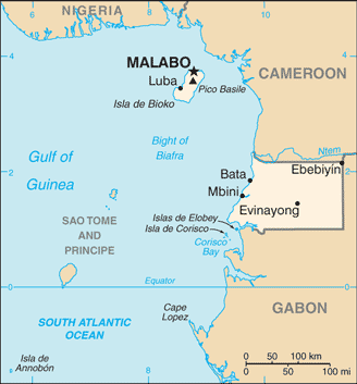
Equatorial Guinea (GPS: 2 00 N, 10 00 E) is located in Central Africa, bordering the Bight of Biafra, between Cameroon and Gabon. The country’s area measurements are total: 28,051 sq km; land: 28,051 sq km, water: 0 sq km. This sovereign state is slightly smaller than Maryland. The total irrigated land is N/A.
One of the crucial features of Equatorial Guinea: Insular and continental regions widely separated. Despite its name, no part of the Equator passes through Equatorial Guinea. The mainland part of the country is located just north of the Equator.
It’s significant, and at the same time, the principal city, Malabo’s GPS coordinates are 3 45 N 8 47 E. Malabo’s local time is 6 hours ahead of Washington DC during Standard Time. The capital’s time difference: UTC+1.
Equatorial Guinea gained independence in 1968 after 190 years of Spanish rule; It is one of the smallest countries in Africa, consisting of a mainland territory and five inhabited islands. The capital of Malabo is located on the island of Bioko, approximately 25 km from the Cameroonian coastline in the Gulf of Guinea. Between 1968 and 1979, autocratic President Francisco MACIAS NGUEMA virtually destroyed all of its political, economic, and social institutions before being deposed by his nephew Teodoro OBIANG NGUEMA MBASOGO in a coup. President OBIANG has ruled since October 1979. He has been elected several times since 1996 and was most recently reelected in 2016.
Although nominally a constitutional democracy since 1991, presidential and legislative elections since 1996 have generally been labeled as flawed. The president exerts almost total control over the political system and has placed legal and bureaucratic barriers that hinder political opposition. Equatorial Guinea has experienced rapid economic growth due to the discovery of large offshore oil reserves. In the last decade, it had become Sub-Saharan Africa’s third-largest oil exporter, though, in 2018, it slipped to 5th place. Despite the country’s economic windfall from oil production, resulting in a massive increase in government revenue in recent years, the drop in global oil prices has placed a significant strain on the state budget. The country has been in recession since 2014. Oil revenues have mainly been used to develop infrastructure, and there have been limited improvements in the population’s living standards. Equatorial Guinea continues to seek to diversify its economy and to increase foreign investment. The country hosts major regional and international conferences and desires a more significant role in international affairs and leadership in the sub-region.
Equatorial Guinea’s names conventional long form: the Republic of Equatorial Guinea, traditional short form: Equatorial Guinea, local long form: Republica de Guinea Ecuatorial/Republique de Guinee Equatoriale, local short form: Guinea Ecuatorial/Guinee Equatoriale, former: Spanish Guinea, etymology: the country is named for the Guinea region of West Africa that lies along the Gulf of Guinea and stretches north to the Sahel; the “equatorial” refers to the fact that the country lies just north of the Equator.
Equatorial Guinea’s terrain is typically coastal plains rise to interior hills; islands are volcanic. The country’s mean elevation: 577 m, elevation extremes; lowest point: Atlantic Ocean 0 m, highest point: Pico Basile 3,008 m.
The general climate in the country; tropical: always hot, humid.
The total number of border countries is 2, Cameroon 183 km, Gabon 345 km are the neighboring nations with the indicated border lengths. Equatorial Guinea’s coastline is 296 km, while its marital claims are: territorial sea: 12 nautical miles, exclusive economic zone: 200 nautical miles. Waterways: N/A. Land use: agricultural land: 10.1%; arable land 4.3%; permanent crops 2.1%; permanent pasture 3.7%; forest: 57.5%; other: 32.4% (2011 estimate).
The population in Equatorial Guinea 797,457 (July 2018 estimate), urban population: 39.9% of total population (2015), major urban area’s population: MALABO (capital) 145,000 (2014), while Equatorial Guinea has N/A. Their spoken languages are Spanish (official language), 67.6%, other (includes French (official language), Fang, Bubi) 32.4% (1994 census). The main religions in Equatorial Guinea are nominally Christian and predominantly Roman Catholic, pagan practices. The nation uses a mixed system of civil and customary law. It is a(n) presidential republic, National holiday(s) Independence Day, 12 October (1968).
Economic overview for the country: Exploitation of oil and gas deposits, beginning in the 1990s, has driven economic growth in Equatorial Guinea; A recent rebasing of GDP resulted in an upward revision of the economy’s size by approximately 30%. Forestry and farming are minor components of GDP. Although pre-independence Equatorial Guinea counted on cocoa production for hard currency earnings, the rural economy’s neglect since independence has diminished the potential for agriculture-led growth. Subsistence farming is the dominant form of livelihood. Declining revenue from hydrocarbon production, high levels of infrastructure expenditures, lack of economic diversification, and corruption have pushed the economy into decline in recent years, and limited improvements in the general population’s living conditions. Equatorial Guinea’s real GDP growth has been weak in recent years, averaging -0.5% per year from 2010 to 2014, because of a declining hydrocarbon sector. Inflation remained very low in 2016, down from an average of 4% in 2014. As a middle-income country, Equatorial Guinea is now ineligible for most low-income World Bank and the IMF funding.
The government has been widely criticized for its lack of transparency and misuse of oil revenues and has attempted to address this issue by working toward compliance with the Extractive Industries Transparency Initiative. US foreign assistance to Equatorial Guinea is limited because of US restrictions under the Trafficking Victims Protection Act. Equatorial Guinea hosted two economic diversification symposia in 2014 that focused on attracting investment in five sectors: agriculture and animal ranching, fishing, mining and petrochemicals, tourism, and financial services. Undeveloped mineral resources include gold, zinc, diamonds, columbite-tantalite, and other base metals. In 2017 Equatorial Guinea signed a preliminary agreement with Ghana to sell liquefied natural gas (LNG); As oil production wanes, the government believes LNG could boost revenues, but it will require large investments and long lead times to develop.
Natural resources of Equatorial Guinea: petroleum, natural gas, timber, gold, bauxite, diamonds, tantalum, sand and gravel, clay.
Main export partners for Equatorial Guinea, Africa are China 16.6%, South Korea 15.1%, Spain 9%, Brazil 8.2%, Netherlands 6.8%, South Africa 6.6%, India 5.8%, UK 5.7%, France 5.7% (2015) for petroleum products, timber, while the main import partners for the country are: Netherlands 16.9%, Spain 16.3%, China 14.8%, US 8.9%, Cote d’Ivoire 6%, France 4.8% (2015) for petroleum sector equipment, other equipment, construction materials, vehicles.
When you visit this country in Africa, consider the natural hazards in Equatorial Guinea: Violent windstorms, flash floods. Volcanism: Santa Isabel (elevation 3,007 m), which last erupted in 1923, is the country’s only historically active volcano, Santa Isabel, along with two dormant volcanoes, form Bioko Island in the Gulf of Guinea, while infectious diseases are the degree of risk: very high food or waterborne diseases: bacterial and protozoal diarrhea, hepatitis A, and typhoid fever vectorborne disease: malaria and dengue fever, animal contact disease: rabies (2016). Also, note that Equatorial Guinea faces the following environmental issues: Deforestation (forests are threatened by agricultural expansion, fires, and grazing), Desertification, water pollution (tap water is non-potable), wildlife preservation.
You may also be interested in the countries next to Equatorial Guinea around its total: 528 km border, like Cameroon, Gabon.