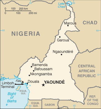
Cameroon (GPS: 6 00 N, 12 00 E) located in Central Africa, bordering the Bight of Biafra, between Equatorial Guinea and Nigeria. The country’s area measurements are total: 475,440 sq km; land: 472,710 sq km, water: 2,730 sq km. This sovereign state is slightly larger than California. The total irrigated land is 290 sq km (2012).
One of Cameroon’s important features: Sometimes referred to as the hinge of Africa because of its central location on the continent and its position at the west-south juncture of the Gulf of Guinea. Throughout the country, there are areas of thermal springs and indications of current or prior volcanic activity. Mount Cameroon, the highest mountain in Sub-Saharan West Africa, is an active volcano.
It’s significant, and at the same time, the principal city, Yaounde’s GPS coordinates are 3 52 N 11 31 E. Yaounde’s local time is 6 hours ahead of Washington DC during Standard Time. The capital’s time difference: UTC+1.
French Cameroon became independent in 1960 as the Republic of Cameroon. The following year the southern portion of neighboring British Cameroon voted to merge with the new country to form the Federal Republic of Cameroon. In 1972, a new constitution replaced the federation with a unitary state, the United Republic of Cameroon. The country has generally enjoyed stability, which has enabled the development of agriculture, roads, railways, and the petroleum industry. Despite slow movement toward democratic reform, political power remains firmly in the hands of President Paul BIYA.
Cameroon’s names conventional long form: the Republic of Cameroon, conventional short form: Cameroon, local long form: the Republique du Cameroun/Republic of Cameroon, local short form: Cameroun/Cameroon, former: French Cameroon, British Cameroon, Federal Republic of Cameroon, United Republic of Cameroon, etymology: in the 15th century, Portuguese explorers named the area near the mouth of the Wouri River the Rio dos Camarones (River of Prawns) after the abundant shrimp in the water; over time the designation became Cameroon in English; this is the only instance where a country named after a crustacean.
In the 15th century, Portuguese explorers named the area near the mouth of the Wouri River the Rio dos Camarones (River of Prawns) after the abundant shrimp in the water; Over time, the designation became Cameroon in English; This is the only instance where a country is named after a crustacean.
Cameroon’s terrain is typically diverse, with a coastal plain in the southwest, dissected plateau in the center, mountains in the west, tables in the north. The country’s mean elevation: 667 m, elevation extremes; lowest point: Atlantic Ocean 0 m, highest point: Fako 4,095 m.
The general climate in the country; varies with terrain, from tropical along the coast to semiarid and hot in the north.
The total number of border countries is 6, Central African Republic 901 km, Chad 1,116 km, Republic of the Congo 494 km, Equatorial Guinea 183 km, Gabon 349 km, Nigeria 1,975 km are the neighboring nations with the indicated border lengths. Cameroon’s coastline is 402 km, while its marital claims are: territorial sea: 12 nautical miles, contiguous zone: 24 nautical miles. Waterways: (major rivers in the south, such as the Wouri and the Sanaga, are largely non-navigable; in the north, the Benue, which connects through Nigeria to the Niger River, is navigable in the rainy season only to the port of Garoua) (2010). Land use: agricultural land: 20.6%; arable land 13.1%; permanent crops 3.3%; permanent pasture 4.2%; forest: 41.7%; other: 37.7% (2011 estimate).
The population in Cameroon 25,640,965 (July 2018 estimate), urban population: 54.4% of total population (2015), major urban area’s population: YAOUNDE (capital) 3.066 million; Douala 2.943 million (2015), while Cameroon has N/A. Their spoken languages are 24 major African language groups, English (official language), French (official language). Main religions in Cameroon are Catholic 38.4%, Protestant 26.3%, other Christian 4.5%, Muslim 20.9%, animist 5.6%, other 1%, non-believer 3.2% (2005 estimate). The nation uses mixed legal system of English common law, French civil law, and customary law. It is a(n) presidential republic, National holiday(s) State Unification Day (National Day), 20 May (1972).
Economic overview for the country: Cameroon’s market-based, diversified economy features oil and gas, timber, aluminum, agriculture, mining, and the service sector. Oil remains Cameroon’s main export commodity, and despite falling global oil prices, it still accounts for nearly 40% of exports. Cameroon’s economy suffers from factors that often impact underdeveloped countries, such as stagnant per capita income, relatively inequitable distribution of income, a top-heavy civil service, endemic corruption, and continuing inefficiencies, sizeable parastatal system in key sectors, and a generally unfavorable climate for business enterprise. Since 1990, the government has embarked on various IMF and World Bank programs designed to spur business investment, increase efficiency in agriculture, improve trade, and recapitalize the nation’s banks.
The IMF continues to press for economic reforms, including increased budget transparency, privatization, and poverty reduction programs. The Government of Cameroon provides subsidies for electricity, food, and fuel that have strained the federal budget and diverted funds from education, healthcare, and infrastructure projects. Low oil prices have led to lower revenues. Cameroon devotes significant resources to several large infrastructure projects currently under construction, including a deep seaport in Kribi and the Lom Pangar Hydropower Project. Cameroon’s energy sector continues to diversify, recently opening a natural gas-powered electricity generating plant. Cameroon continues to seek foreign investment to improve its inadequate infrastructure, create jobs, and improve its economic footprint, but its unfavorable business environment remains a significant deterrent to foreign investment.
Natural resources of Cameroon: petroleum, bauxite, iron ore, timber, hydropower.
Main export partners for Cameroon, Africa are China 16.7%, India 15.7%, Spain 6.2%, Belgium 6.1%, France 6.1%, Portugal 5.6%, Netherlands 5%, Italy 5% (2015) for crude oil and petroleum products, lumber, cocoa beans, aluminum, coffee, cotton, while the main import partners for the country are: China 27.9%, Nigeria 13.9%, France 10.9%, Belgium 4.1% (2015) for machinery, electrical equipment, transport equipment, fuel, food.
When you visit this country in Africa, consider the natural hazards in Cameroon: Volcanic activity with periodic releases of poisonous gases from Lake Nyos and Lake Monoun volcanoes volcanism: Mt. Cameroon (elevation 4,095 m), which last erupted in 2000, is the most frequently active volcano in West Africa, lakes in Oku volcanic field have released fatal levels of gas on occasion, killing some 1,700 people in 1986, while infectious diseases are a degree of risk: very high food or waterborne diseases: bacterial and protozoal diarrhea, hepatitis A, and typhoid fever vectorborne diseases: malaria, dengue fever, and yellow fever water contact disease: schistosomiasis respiratory disease: meningococcal meningitis animal contact disease: rabies (2016). Also, note that Cameroon faces the following environmental issues: Waterborne diseases are prevalent, Deforestation and overgrazing result in erosion, desertification, and reduced quality of pastureland, Poaching, Overfishing, Overhunting.
You may also be interested in the countries next to Cameroon around its total: 5,018 km border, like Central African Republic, Chad, Republic of the Congo, Equatorial Guinea, Gabon, Nigeria.