Niger (GPS: 16 00 N, 8 00 E) located in Western Africa, southeast of Algeria. The country’s area measurements are total: 1.267 million sq km; land: 1,266,700 sq km, water: 300 sq km. This sovereign state is slightly less than twice the size of Texas. The total irrigated land is 1,000 sq km (2012).
One of the essential features of Niger: Landlocked (enclosed or nearly enclosed by land). One of the hottest countries in the world. Northern four-fifths is desert; southern one-fifth is savanna, suitable for livestock and limited agriculture.
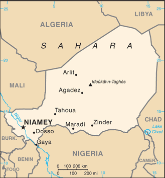
It’s significant, and at the same time, the principal city, Niamey’s GPS coordinates are 13 31 N 2 07 E. Niamey’s local time is 6 hours ahead of Washington DC during Standard Time. The capital’s time difference: UTC+1.
For more information on Niger, please scroll down below the Google Maps.
Google Maps Niger and Niamey, Africa
About Niger in detail
Flag of Niger
Map of Niger
Niger became independent from France in 1960 and experienced single-party and military rule until 1991 when Gen. Ali SAIBOU was forced by public pressure to allow multiparty elections, which resulted in a democratic government in 1993. Political infighting brought the government to a standstill and, in 1996, led to a coup by Col. Ibrahim BARE. In 1999, BARE killed in a counter-coup by military officers who restored democratic rule and held elections that brought Mamadou TANDJA to power in December of that year. TANDJA was reelected in 2004 and, in 2009, spearheaded a constitutional amendment allowing him to extend his term as president. In February 2010, military officers led a coup that deposed TANDJA and suspended the constitution. ISSOUFOU Mahamadou was elected in April 2011 following the coup and reelected to a second term in early 2016.
Niger is one of the world’s poorest countries with minimal government services and insufficient funds to develop its resource base and is ranked last in the world on the United Nations Development Programme’s Human Development Index. The largely agrarian and subsistence-based economy is frequently disrupted by extended droughts common to Africa’s Sahel region. The Nigerien government continues its attempts to diversify the economy through increased oil production and mining projects. A Tuareg rebellion emerged in 2007 and ended in 2009. Niger faces increased security concerns on its borders from various external threats, including insecurity in Libya, spillover from the conflict in Mali, and violent extremism in northeastern Nigeria.
Niger’s names conventional long form: the Republic of Niger, traditional short form: Niger, local long form: Republique du Niger, local temporary state: Niger, etymology: named for the Niger River that passes through the southwest of the country; from a native term “Ni Gir” meaning “River Gir.” Named for the Niger River that passes through the southwest of the country; From a native word “Ni Gir,” meaning “River Gir.”
Niger’s terrain is typically predominately desert plains and dunes, flat to rolling plains in the south; hills in the north. The country’s mean elevation: 474 m, elevation extremes; lowest point: Niger River 200 m, highest point: Idoukal-n-Tags 2,022 m.
The country’s general climate is desert: mostly hot, dry, dusty: tropical in the extreme south.
The total number of border countries is 7, Algeria 951 km, Benin 277 km, Burkina Faso 622 km, Chad 1,196 km, Libya 342 km, Mali 838 km, Nigeria 1,608 km are the neighboring nations with the indicated border lengths. Niger’s coastline is 0 km (landlocked country), while its marital claims are: none. Waterways: 300 km (the Niger, the only major river, is navigable to Gaya between September and March) (2012). Land use: agricultural land: 35.1%; arable land 12.3%; permanent crops 0.1%; permanent pasture 22.7%; forest: 1%; other: 63.9% (2011 estimate).
The population in Niger 19,866,231 (July 2018 estimate), urban population: 18.7% of total population (2015), major urban area’s population: NIAMEY (capital) 1.09 million (2015), while Niger has the majority of the populace is located in the southernmost extreme of the country along the border with Nigeria and Benin. Their spoken languages are French (official language), Hausa, Djerma. Main religions in Niger are Muslim 80%, other (includes indigenous beliefs and Christian) 20%. The nation uses mixed legal system of civil law (based on French civil law), Islamic law, and customary law. It is a(n) semi-presidential republic, National holiday(s) Republic Day, 18 December (1958).
Economic overview for the country: Niger is a landlocked, sub-Saharan nation whose economy centers on subsistence crops, livestock, and some of its largest uranium deposits. Agriculture contributes approximately 40% of GDP and provides a livelihood for over 80% of the population. The UN ranked Niger as the second least developed country in the world in 2016 due to multiple factors such as food insecurity, lack of industry, high population growth, a weak educational sector, and few prospects for work outside of subsistence farming and herding.
Since 2011 public debt has increased due to efforts to scale-up public investment, particularly that related to infrastructure and increased security spending. The government relies on foreign donor resources for a large portion of its fiscal budget. In recent years, the economy has been hurt by terrorist activity near its uranium mines and by instability in Mali and the country’s Diffa region; security concerns have resulted in increased support from regional and international partners on defense. Low uranium prices, demographics, and security expenditures may continue to put pressure on the government’s finances.
The Government of Niger plans to exploit oil, gold, coal, and other mineral resources to sustain future growth. Although Niger has sizable reserves of oil, the prolonged drop in oil prices has reduced profitability. Food insecurity and drought remain perennial problems for Niger, and the government plans to invest more in irrigation. Niger’s three-year $131 million IMF Extended Credit Facility (ECF) agreement for 2012-2015 was extended until the end of 2016. In February 2017, the IMF approved a new 3-year $134 million ECF. In June 2017, The World Bank’s International Development Association (IDA) granted Niger $1 billion over three years for IDA18, a program to boost its development and alleviate poverty.
A $437 million Millennium Challenge Account compact for Niger, commencing in FY18, will focus on large-scale irrigation infrastructure development and community-based, climate-resilient agriculture while promoting sustainable increases in agricultural productivity and sales. Formal private sector investment needed for economic diversification and growth remains a challenge, given the country’s limited domestic markets, access to credit, and competitiveness. Although President ISSOUFOU is courting foreign investors, including those from the US, as of April 2017, no US firms were operating in Niger. In November 2017, the National Assembly passed the 2018 Finance Law geared towards raising government revenues and moving away from international support.
Natural resources of Niger: uranium, coal, iron ore, tin, phosphates, gold, molybdenum, gypsum, salt, petroleum.
Main export partners for Niger, Africa are France 53.1%, Nigeria 20.3%, China 13.8% (2015) for uranium ore, livestock, cowpeas, onions, while the main import partners for the country are: France 12%, China 10.5%, Nigeria 9.5%, French Polynesia 9%, Togo 6.1%, Belgium 5.3%, Cote d’Ivoire 5.3%, US 4.3% (2015) for foodstuffs, machinery, vehicles, and parts, petroleum, cereals.
When you visit this country in Africa, consider the natural hazards in Niger: Recurring droughts, while infectious diseases are a degree of risk: very high food or waterborne diseases: bacterial and protozoal diarrhea, hepatitis A, and typhoid fever vectorborne diseases: malaria and dengue fever water contact disease: schistosomiasis respiratory disease: meningococcal meningitis animal contact disease: rabies (2016). Also, note that Niger faces the following environmental issues: Overgrazing, Soil erosion, Deforestation, Desertification, Contaminated water, Inadequate potable water, wildlife populations (such as elephant, hippopotamus, giraffe, and lion) threatened because of poaching and habitat destruction.
You may also be interested in the countries next to Niger around its total: 5,834 km border, like Algeria, Benin, Burkina Faso, Chad, Libya, Mali, Nigeria.