Burkina Faso (GPS: 13 00 N, 2 00 W) located in Western Africa, north of Ghana. The country’s area measurements are total: 274,200 sq km; land: 273,800 sq km, water: 400 sq km. This sovereign state is slightly larger than Colorado. The total irrigated land is 550 sq km (2012).
One of the important features of Burkina Faso: Landlocked savanna cut by the three principal rivers of the Black, Red, and White Voltas.
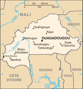
It’s significant, and at the same time, the principal city, Ouagadougou’s GPS coordinates are 12 22 N 1 31 W. Ouagadougou’s local time is 5 hours ahead of Washington DC during Standard Time. The capital’s time difference: UTC 0.
Burkina Faso (formerly Upper Volta) achieved independence from France in 1960. Multiparty elections followed repeated military coups during the 1970s and 1980s in the early 1990s. Former President Blaise COMPAORE (1987-2014) resigned in late October 2014 following popular protests against his efforts to amend the constitution’s two-term presidential limit. An interim administration organized presidential and legislative elections – held in November 2015 – where Roch Marc Christian KABORE was elected president. The country experienced terrorist attacks in its capital in 2016, 2017, and 2018 and mobilized resources to counter terrorist threats, mainly in its northern and eastern regions.
It experienced over 100 attacks by violent extremists in the first quarter of 2019. Growing insecurity resulted in nearly 500,000 internally displaced persons and more than 2,000 closed schools. The Government of Burkina Faso has made numerous arrests of terrorist suspects, augmented the size of its special terrorism detachment ‘Groupement des Forces Anti-Terroristes (GFAT)’ in the country’s north, and joined the newly-created G5 Sahel Joint Force to fight terrorism and criminal trafficking groups with regional neighbors Chad, Mali, Mauritania, and Niger.
In 2017, the Sahara Branch of al-Qa’ida in the Islamic Maghreb, al-Murabitoun, Ansar al-Dine, and the Macina Liberation Front came together form Jama’at Nusrat al-Islam wal-Muslimin (JNIM). JNIM and other groups like Ansarul Islam and ISIS in the Greater Sahara operate in Burkina Faso. Burkina Faso’s high population growth, recurring drought, pervasive and perennial food insecurity, and limited natural resources result in poor economic prospects for most of its citizens. (2019)
Burkina Faso’s names conventional long form: none, conventional short form: Burkina Faso, local long form: none, local short form: Burkina Faso, former: Upper Volta, Republic of Upper Volta, etymology: name translates as “Land of the honest (incorruptible) men.” The name translates as “Land of the Honest (Incorruptible) Men.”
Burkina Faso’s terrain is typically flat to dissected, undulating plains; hills in west and southeast. The country’s mean elevation: 297 m, elevation extremes; lowest point: Mouhoun (Black Volta) River 200 m, highest point: Tena Kourou 749 m.
The general climate in the country; tropical: warm, dry winters: hot, wet summers.
The total number of border countries is 6, Benin 386 km, Cote d’Ivoire 545 km, Ghana 602 km, Mali 1,325 km, Niger 622 km, Togo 131 km are the neighboring nations with the indicated border lengths. Burkina Faso’s coastline is 0 km (landlocked country), while its marital claims are: none. Waterways: N/A. Land use: agricultural land: 43%; arable land 20.8%; permanent crops 0.3%; permanent pasture 21.9%; forest: 20.4%; other: 36.6% (2011 estimate).
The population in Burkina Faso 19,742,715 (July 2018 estimate), urban population: 29.9% of total population (2015), major urban area’s population: OUAGADOUGOU (capital) 2.741 million (2015), while Burkina Faso has N/A. Their spoken languages are French (official language), native African languages belonging to Sudanic family spoken by 90% of the population. Main religions in Burkina Faso are Muslim 61.6%, Catholic 23.2%, traditional/animist 7.3%, Protestant 6.7%, other/no answer 0.2%, none 0.9% (2010 estimate). The nation uses civil law based on the French model and customary law. It is a(n) presidential republic, National holiday(s) Republic Day, 11 December (1958).
Economic overview for the country: Burkina Faso is a poor, landlocked country that depends on adequate rainfall. Irregular patterns of rainfall, poor soil, and the lack of adequate communications and other infrastructure contribute to the economy’s vulnerability to external shocks. About 80% of the population is engaged in subsistence farming, and cotton is the main cash crop. The country has few natural resources and a weak industrial base.
Cotton and gold are Burkina Faso’s key exports – gold has accounted for about three-quarters of the country’s total export revenues. Burkina Faso’s economic growth and revenue depend largely on production levels and global prices for the two commodities. The country has seen an upswing in gold exploration, production, and exports. In 2016, the government adopted a new development strategy, outlined in the 2016-2020 National Plan for Economic and Social Development, that aims to reduce poverty, build human capital, and satisfy basic needs.
A new three-year IMF program (2018-2020), approved in 2018, will allow the government to reduce the budget deficit and preserve critical spending on social services and priority public investments. While the end of the political crisis has allowed Burkina Faso’s economy to resume positive growth, the country’s fragile security situation could put these gains at risk. Political insecurity in neighboring Mali, unreliable energy supplies, and poor transportation links pose long-term challenges.
Natural resources of Burkina Faso: manganese, limestone, marble; small deposits of gold, phosphates, pumice, salt.
Main export partners for Burkina Faso, Africa are Switzerland 53.3%, India 14.5% (2015) for gold, cotton, livestock, while the main import partners for the country are: Cote d’Ivoire 23.1%, France 11.1%, Togo 7.5%, China 4.8%, Ghana 4.6% (2015) for capital goods, foodstuffs, petroleum.
When you visit this country in Africa, consider the natural hazards in Burkina Faso: Recurring droughts, while infectious diseases are a degree of risk: very high food or waterborne diseases: bacterial and protozoal diarrhea, hepatitis A, and typhoid fever vectorborne disease: dengue fever, malaria, and yellow fever water contact disease: schistosomiasis respiratory disease: meningococcal meningitis animal contact disease: rabies (2016). Also, note that Burkina Faso faces the following environmental issues: Recent droughts and desertification severely affecting agricultural activities, population distribution, and the economy, Overgrazing, Soil degradation, Deforestation (2019).
You may also be interested in the countries next to Burkina Faso around its total: 3,611 km border, like Benin, Cote d’Ivoire, Ghana, Mali, Niger, Togo.