Benin (GPS: 9 30 N, 2 15 E) located in Western Africa, bordering the Bight of Benin, between Nigeria and Togo. The country’s area measurements are total: 112,622 sq km; land: 110,622 sq km, water: 2,000 sq km. This sovereign state is slightly smaller than Pennsylvania. The total irrigated land is 230 sq km (2012).
Benin’s essential features: Sandbanks create difficult access to the coast with no natural harbors, river mouths, or islands.
It’s significant, and at the same time, the principal city, Porto-Novo’s GPS coordinates are 6 29 N 2 37 E. Porto-Novo’s local time is 6 hours ahead of Washington DC during Standard Time. The capital’s time difference: UTC+1.
For more information on Benin, please scroll down below the Google Maps.
Google Maps Benin and Porto-Novo, Africa
About Benin in detail
Flag of Benin
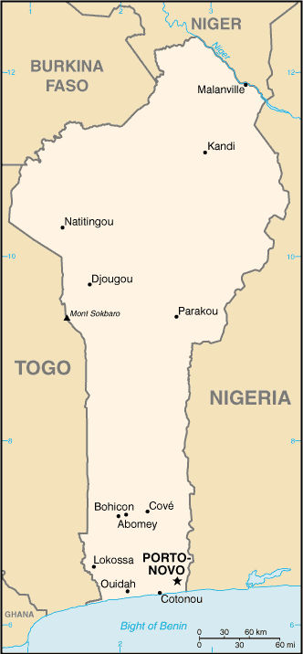
Map of Benin
Present-day Benin was Dahomey’s site, a West African kingdom that rose to prominence in about 1600 and over the next two and a half centuries became a regional power, largely based on its slave trade. France began to control Dahomey’s coastal areas in the second half of the 19th century; The entire kingdom was conquered by 1894. French Dahomey achieved independence in 1960; It changed its name to the Republic of Benin in 1975.
A succession of military governments ended in 1972 with the rise to power of Mathieu KEREKOU and the establishment of a government based on Marxist-Leninist principles. A move to a representative government began in 1989. Two years later, free elections ushered in former Prime Minister Nicephore SOGLO as president, marking the first successful transfer of power in Africa from a dictatorship to a democracy. KEREKOU returned to power by-elections held in 1996 and 2001, though some irregularities were alleged. KEREKOU stepped down at the end of his second term in 2006 and was succeeded by Thomas YAYI Boni, a political outsider and independent, who won a second five-year term in March 2011. Patrice TALON, a wealthy businessman, took office in 2016 after campaigning to restore public confidence in the government.
Benin’s names conventional long form: the Republic of Benin, traditional short form: Benin, local long form: Republique du Benin, local short state: Benin, former: Dahomey, etymology: named for the Bight of Benin, the body of water on which the country lies. Named for the Bight of Benin, the body of water on which the land lies.
Benin’s terrain is typically mostly flat to the undulating plain; some hills and low mountains. The country’s mean elevation: 273 m, elevation extremes; lowest point: Atlantic Ocean 0 m, Mont Sokbaro 658 m.
The country’s general climate is tropical: hot, humid in the south: semiarid in the north.
The total number of border countries is 4, Burkina Faso 386 km, Niger 277 km, Nigeria 809 km, Togo 651 km are the neighboring nations with the indicated border lengths. Benin’s coastline is 121 km, while its marital claims are: territorial sea: 200 nautical miles. Waterways: 150 km (seasonal navigation on River Niger along the northern border) (2011). Land use: agricultural land: 31.3%; arable land 22.9%; permanent crops 3.5%; permanent pasture 4.9%; forest: 40%; other: 28.7% (2011 estimate).
The population in Benin 11,340,504 (July 2018 estimate), urban population: 44% of total population (2015), major urban area’s population: PORTO-NOVO (capital) 268,000 (2014); COTONOU (seat of government) 682,000; Abomey-Calavi 757,000 (2015), while Benin has N/A. Their spoken languages are French (official language), Fon and Yoruba (most common vernaculars in south), tribal languages (at least six major ones in north). Main religions in Benin are Muslim 27.7%, Catholic 25.5%, Protestant 13.5% (Celestial 6.7%, Methodist 3.4%, other Protestant 3.4%), Vodoun 11.6%, other Christian 9.5%, other traditional religions 2.6%, other 2.6%, none 5.8% (2013 estimate). The nation uses civil law system modeled largely on the French system and some customary law. It is a(n) presidential republic, National holiday(s) National Day, 1 August (1960).
Economic overview for the country: The free market economy of Benin has grown consecutively for four years, though growth slowed in 2017, as its close trade links to Nigeria expose Benin to risks from volatile commodity prices. Cotton is an essential export commodity, with export earnings significantly impacted by cotton prices in the broader market. The economy began deflating in 2017, with the consumer price index falling 0.8%. During the first two years of President TALON’s administration, which started in April 2016, the government has followed an ambitious action plan to kickstart development through infrastructure, education, agriculture, and governance. Electricity generation, which has constrained Benin’s economic growth, has increased, and blackouts have been considerably reduced.
Private foreign direct investment is small, and foreign aid accounts for a large proportion of investment in infrastructure projects. Benin has appealed for international assistance to mitigate piracy against commercial shipping in its territory and has used equipment from donors effectively against such piracy. Pilferage has significantly dropped at the Port of Cotonou, though the port is still struggling with effective implementation of the International Ship and Port Facility Security (ISPS) Code. Projects included in Benin’s $307 million Millennium Challenge Corporation (MCC) first compact (2006-2011) were designed to increase investment and private sector activity by improving critical institutional and physical infrastructure. The four projects focused on access to land, access to financial services, access to justice, and access to markets (including the port). The Port of Cotonou is a significant contributor to Benin’s economy, with revenues projected to account for more than 40% of Benin’s national budget.
Benin will need further efforts to upgrade infrastructure, stem corruption, and expand access to foreign markets to achieve its potential. In September 2015, Benin signed a second MCC Compact for $375 million that entered into force in June 2017 and is designed to strengthen the national utility service provider, attract private sector investment, fund infrastructure investments in electricity generation and distribution, and develop off-grid electrification for poor and unserved households. As part of the Government of Benin’s action plan to spur growth, Benin passed public, private partnership legislation in 2017 to attract more foreign investment, place more emphasis on tourism, facilitate the development of new food processing systems and agricultural products, encourage further information and communication technology, and establish Independent Power Producers. In April 2017, the IMF approved a three-year $150.4 million Extended Credit Facility agreement to maintain debt sustainability and boost donor confidence.
Natural resources of Benin: small offshore oil deposits, limestone, marble, timber.
Main export partners for Benin, Africa are India 24.2%, Gabon 14.6%, China 7.2%, Niger 6%, Bangladesh 5%, Nigeria 4.9%, Vietnam 4.2% (2015) for cotton, cashews, shea butter, textiles, palm products, seafood, while the main import partners for the country are: China 42.1%, US 8.9%, India 5.7%, Malaysia 4.8%, Thailand 4.3%, France 4% (2015) for foodstuffs, capital goods, petroleum products.
When you visit this country in Africa, consider the natural hazards in Benin: Hot, dry, dusty harmattan wind may affect north from December to March, while infectious diseases are a degree of risk: very high food or waterborne diseases: bacterial and protozoal diarrhea, hepatitis A, and typhoid fever vectorborne diseases: dengue fever, malaria, and yellow fever respiratory disease: meningococcal meningitis animal contact disease: rabies (2016). Also, note that Benin faces the following environmental issues: Inadequate supplies of potable water, water pollution, Poaching threatens wildlife populations, Deforestation, Desertification (regular droughts accelerate the spread of the desert into agricultural lands in the north).
You may also be interested in the countries next to Benin around its total: 2,123 km border, like Burkina Faso, Niger, Nigeria, Togo.