Burundi (GPS: 3 30 S, 30 00 E) located in Central Africa, east of the Democratic Republic of the Congo, west of Tanzania. The country’s area measurements are total: 27,830 sq km; land: 25,680 sq km, water: 2,150 sq km. This sovereign state is slightly smaller than Maryland. The total irrigated land is 230 sq km (2012).
One of the essential features of Burundi: Landlocked (enclosed or nearly enclosed by land). Straddles crest of the Nile-Congo watershed. The Kagera, which drains into Lake Victoria, is the most remote headstream of the White Nile.
It’s significant, and at the same time, the principal city, Bujumbura’s GPS coordinates are 3 22 S 29 21 E. Bujumbura’s local time is 7 hours ahead of Washington DC during Standard Time. The capital’s time difference: UTC+2.
For more information on Burundi, please scroll down below the Google Maps.
Google Maps Burundi and Bujumbura, Africa
About Burundi in detail
Flag of Burundi
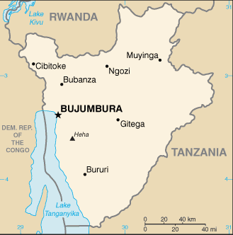
Map of Burundi
Burundi is a small country in Central-East Africa bordered by Tanzania, Rwanda, the Democratic Republic of Congo, and Lake Tanganyika. Burundi gained its independence from Belgium in 1962 as the Kingdom of Burundi, but the monarchy was overthrown in 1966, and a republic was established. Political violence and non-democratic transfers of power have marked much of its history; Burundi’s first democratically elected president, a Hutu, was assassinated in October 1993 after only 100 days in office.
The internationally brokered Arusha Agreement, signed in 2000, and subsequent ceasefire agreements with armed movements ended the 1993-2005 civil war. Burundi’s second democratic elections were held in 2005. Pierre NKURUNZIZA was elected president in 2005 and 2010, and again in a controversial election in 2015. Burundi continues to face many economic and political challenges.
Burundi’s names conventional long form: the Republic of Burundi, traditional short form: Burundi, local long form: Republique du Burundi/Republika y’u Burundi, local short form: Burundi, former: Urundi, etymology: name derived from the pre-colonial Kingdom of Burundi (17th-19th century). Name derived from the pre-colonial Kingdom of Burundi (17th-19th century).
Burundi’s terrain is typically hilly and mountainous, dropping to a plateau in the east, some plains. The country’s mean elevation: 1,504 m, elevation extremes; lowest point: Lake Tanganyika 772 m, highest point: Heha 2,670 m.
The general climate in the country; equatorial: high plateau with considerable altitude variation (772 m to 2,670 m above sea-level): average annual temperature varies with altitude from 23 to 17 degrees Celsius but is generally moderate as the average height is about 1,700 m: average yearly rainfall is about 150 cm: two wet seasons (February to May and September to November), and two dry seasons (June to August and December to January).
The total number of border countries is 3; the Democratic Republic of the Congo 236 km, Rwanda 315 km, Tanzania 589 km are the neighboring nations with the indicated border lengths. Burundi’s coastline is 0 km (landlocked country), while its marital claims are: none. Waterways: (mainly on Lake Tanganyika between Bujumbura, Burundi’s principal port, and lake ports in Tanzania, Zambia, and the Democratic Republic of the Congo) (2011). Land use: agricultural land: 73.3%; arable land 38.9%; permanent crops 15.6%; permanent pasture 18.8%; forest: 6.6%; other: 20.1% (2011 estimate).
The population in Burundi 11,844,520 (July 2018 estimate), urban population: 12.1% of total population (2015), major urban area’s population: BUJUMBURA (capital) 751,000 (2015), while Burundi has N/A. Their spoken languages are: Kirundi 29.7% (official language), Kirundi and other languages: 9.1%, French (official language) 0.3%, Swahili and Swahili 0.2% (along Lake Tanganyika and in the Bujumbura area), English 0.06%, more than two languages 3.7%, unspecified 56.9% (2008 estimate). Main religions in Burundi are Catholic 62.1%, Protestant 23.9% (includes Adventist 2.3% and other Protestant 21.6%), Muslim 2.5%, other 3.6%, unspecified 7.9% (2008 estimate). The nation uses mixed legal system of Belgian civil law and customary law. It is a(n) presidential republic, National holiday(s) Independence Day, 1 July (1962).
Economic overview for the country: Burundi is a landlocked, resource-poor country with an underdeveloped manufacturing sector. Agriculture accounts for over 40% of GDP and employs more than 90% of the population. Burundi’s primary exports are coffee and tea, which account for more than half of foreign exchange earnings, but these earnings are subject to fluctuations in weather and international coffee and tea prices; Burundi is heavily dependent on aid from bilateral and multilateral donors, as well as foreign exchange earnings from participation in the African Union Mission to Somalia (AMISOM).
Foreign aid represented 48% of Burundi’s national income in 2015, one of the highest percentages in Sub-Saharan Africa. Still, this figure decreased to 33.5% in 2016 due to political turmoil surrounding President NKURUNZIZA’s bid for a third term. Burundi joined the East African Community (EAC) in 2009. Burundi faces several underlying weaknesses low governmental capacity, corruption, a high poverty rate, low educational levels, a weak legal system, a poor transportation network, and overburdened utilities that have prevented the implementation of planned economic reforms.
Most Burundians’ purchasing power has decreased as wage increases have not kept pace with inflation, which reached approximately 18% in 2017. Real GDP growth dropped precipitously following political events in 2015 and has yet to recover to pre-conflict levels. Continued resistance by donors and the international community will restrict Burundi’s economic growth as it deals with a massive current account deficit.
Main export partners for Burundi, Africa are Germany 12.3%, Pakistan 10.7%, the Democratic Republic of the Congo 10.7%, Uganda 8.1%, Sweden 7.8%, US 7.1%, Belgium 6.3%, Rwanda 4.6%, France 4.4% (2015) for coffee, tea, sugar, cotton, hides, while the main import partners for the country are: Kenya 15%, Saudi Arabia 14%, Belgium 9.9%, Tanzania 8.3%, Uganda 7.3%, China 7.1%, India 4.9%, France 4% (2015) for capital goods, petroleum products, foodstuffs.
When you visit this country in Africa, consider the natural hazards in Burundi: Flooding, landslides, drought, while infectious diseases are a degree of risk: very high food or waterborne diseases: bacterial and protozoal diarrhea, hepatitis A, and typhoid fever vectorborne diseases: malaria and dengue fever water contact disease: schistosomiasis animal contact disease: rabies (2016). Also, note that Burundi faces the following environmental issues: Soil erosion as a result of overgrazing and the expansion of agriculture into marginal lands; deforestation (little forested land remains because of uncontrolled cutting of trees for fuel), Habitat loss threatens wildlife populations.
You may also be interested in the countries next to Burundi around its total: 1,140 km border, like the Democratic Republic of the Congo, Rwanda, Tanzania.