Uganda (GPS: 1 00 N, 32 00 E) is located in East-Central Africa, west of Kenya, east of the Democratic Republic of the Congo. The country’s area measurements are total: 241,038 sq km; land: 197,100 sq km, water: 43,938 sq km. This sovereign state is slightly smaller than Oregon. The total irrigated land is 140 sq km (2012).
One of the essential features of Uganda: Landlocked (enclosed or nearly enclosed by land). A fertile, well-watered country with many lakes and rivers. Lake Victoria, the world’s largest tropical lake and the second-largest freshwater lake, is shared among three countries: Kenya, Tanzania, and Uganda.
It’s significant, and at the same time, the principal city, Kampala’s GPS coordinates are 0 19 N 32 33 E. Kampala’s local time is 8 hours ahead of Washington DC during Standard Time. The capital’s time difference: UTC+3.
For more information on Uganda, please scroll down below the Google Maps.
Google Maps Uganda and Kampala, Africa
About Uganda in detail
Flag of Uganda
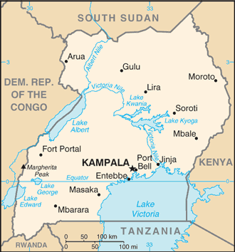
Map of Uganda
Britain’s colonial boundaries to delimit Uganda grouped a wide range of ethnic groups with different political systems and cultures. These differences complicated the establishment of an active political community after independence achieved in 1962. The dictatorial regime of Idi AMIN (1971-79) was responsible for the deaths of some 300,000 opponents; Guerrilla war and human rights abuses under Milton OBOTE (1980-85) claimed at least another 100,000 lives. The rule of Yoweri MUSEVENI since 1986 has brought relative stability and economic growth to Uganda. In December 2017, parliament approved the removal of presidential age limits, thereby making it possible for MUSEVENI to continue standing for office. However, Uganda faces numerous challenges that could affect future stability, including explosive population growth, power and infrastructure constraints, corruption, underdeveloped democratic institutions, and human rights deficits.
Uganda’s names conventional long form: the Republic of Uganda, conventional short form: Uganda, etymology: from the Swahili “Buganda,” adopted by the British as the name for their East African colony in 1894; Buganda had been a powerful East African state during the 18th and 19th centuries. From the name “Buganda” adopted by the British as the designation for their East African colony in 1894, Buganda had been a powerful East African state during the 18th and 19th centuries.
Uganda’s terrain is typically mostly plateau with rim of mountains. The country’s mean elevation: N/A, elevation extremes; lowest point: Lake Albert 621 m, highest point: Margherita Peak on Mount Stanley 5,110 m.
The country’s general climate is tropical: generally rainy with two dry seasons (December to February, June to August): semiarid in the northeast.
The total number of border countries is 5, the Democratic Republic of the Congo 877 km, Kenya 814 km, Rwanda 172 km, South Sudan 475 km, Tanzania 391 km are the neighboring nations with the indicated border lengths. Uganda’s coastline is 0 km (landlocked country), while its marital claims are: none. Waterways: (there are no longer navigable stretches of river in Uganda; parts of the Albert Nile that flow out of Lake Albert in the northwestern part of the country are navigable; several lakes including Lake Victoria and Lake Kyoga have substantial traffic; Lake Albert is navigable along a 200-km stretch from its northern tip to its southern shores) (2011). Land use: agricultural land: 71.2%; arable land 34.3%; permanent crops 11.3%; permanent pasture 25.6%; forest: 14.5%; other: 14.3% (2011 estimate).
The population in Uganda 40,853,749 (July 2018 estimate), urban population: 16.1% of total population (2015), major urban area’s population: KAMPALA (capital) 1.936 million (2015), while Uganda has N/A. Their spoken languages are: English (official language national language, taught in grade schools, used in courts of law and by most newspapers and some radio broadcasts), Ganda or Luganda (most widely used of the Niger-Congo languages, preferred for native language publications in the capital and maybe taught in school), other Niger-Congo languages, Nilo-Saharan languages, Swahili, Arabic. Main religions in Uganda are Protestant 45.1% (Anglican 32.0%, Pentecostal/Born Again/Evangelical 11.1%, Seventh Day Adventist 1.7%, Baptist .3%), Roman Catholic 39.3%, Muslim 13.7%, other 1.6%, none 0.2% (2014 estimate). The nation uses mixed legal system of English common law and customary law. It is a(n) presidential republic, National holiday(s) Independence Day, 9 October (1962).
Economic overview for the country: Uganda has substantial natural resources, including fertile soils, regular rainfall, significant reserves of recoverable oil, and small copper, gold, and other minerals. Agriculture is one of the most critical sectors of the economy, employing 72% of the workforce. The country’s export market suffered a significant slump following the outbreak of conflict in South Sudan but has recovered lately, mainly due to record coffee harvests, which account for 16% of exports, and increasing gold exports, which account for 10% of exports. Uganda has a small industrial sector dependent on imported inputs such as refined oil and heavy equipment. Overall, several supply-side constraints have hampered productivity, including insufficient infrastructure, lack of modern technology in agriculture, and corruption. Uganda’s economic growth has slowed since 2016 as government spending, and public debt has grown. Uganda’s budget is dominated by energy and road infrastructure spending, while Uganda relies on donor support for long-term drivers of growth, including agriculture, health, and education.
The largest infrastructure projects are externally financed through concessional loans but at inflated costs. As a result, debt servicing for these loans is expected to rise. Oil revenues and taxes are expected to become a larger government funding source as oil production starts in the next three to 10 years. Over the next three to five years, foreign investors are planning to invest $9 billion in production facilities projects, $4 billion in an export pipeline, and a $2-3 billion refinery to produce petroleum products for the domestic and East African Community markets. Furthermore, the government is looking to build several hundred million dollars’ worths of highway projects to the oil region.
Uganda faces many economic challenges. Instability in South Sudan has led to a sharp increase in Sudanese refugees and disrupts Uganda’s main export market. Additional economic risks include poor economic management, endemic corruption, and the government’s failure to invest adequately in the health, education, and economic opportunities for a burgeoning young population. Uganda has one of the lowest electrification rates in Africa – only 22% of Ugandans have access to electricity, dropping to 10% in rural areas.
Main export partners for Uganda, Africa are Rwanda 10.7%, UAE 9.9%, the Democratic Republic of the Congo 9.8%, Kenya 9.7%, Italy 5.8%, Netherlands 4.8%, Germany 4.7%, China 4.1% (2015) for coffee, fish and fish products, tea, cotton, flowers, horticultural products; gold, while the main import partners for the country are: Kenya 16.4%, UAE 15.5%, India 13.4%, China 13.1% (2015) for capital equipment, vehicles, petroleum, medical supplies; cereals.
When you visit this country in Africa, consider the natural hazards in Uganda: N/A, while infectious diseases are a degree of risk: very high food or waterborne diseases: bacterial diarrhea, hepatitis A and E, and typhoid fever vectorborne diseases: malaria, dengue fever, and trypanosomiasis-Gambiense (African sleeping sickness)water contact disease: schistosomiasis animal contact disease: rabies (2016). Also, note that Uganda faces the following environmental issues: Draining of wetlands for agricultural use, Deforestation, Overgrazing, Soil erosion, water pollution from industrial discharge, and water hyacinth infestation in Lake Victoria, widespread poaching.
You may also be interested in the countries next to Uganda around its total: 2,729 km border, like the Democratic Republic of the Congo, Kenya, Rwanda, South Sudan, Tanzania.