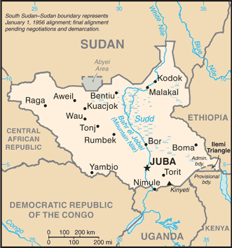
South Sudan (GPS: 8 00 N, 30 00 E) located in East-Central Africa; south of Sudan, north of Uganda and Kenya, west of Ethiopia. The country’s area measurements are total: 644,329 sq km; water: N/A. This sovereign state is more than four times the size of Georgia; slightly smaller than Texas. The total irrigated land is 1,000 sq km (2012).
One of the essential features of South Sudan: Landlocked (enclosed or nearly enclosed by land). The Sudd is a vast swamp in the north-central region of South Sudan, formed by the White Nile; its size is variable but can reach 15% of the country’s total area during the rainy season. It is one of the world’s most extensive wetlands.
It’s significant, and at the same time, the principal city, Juba’s GPS coordinates are 04 51 N 31 37 E. Juba’s local time is 8 hours ahead of Washington DC during Standard Time. The capital’s time difference: UTC+3.
British explorer Samuel BAKER established the colony of Equatoria in 1870, in the name of the Ottoman Khedive of Egypt who claimed the territory. Headquartered in Gondokoro (near modern-day Juba), Equatoria in theory composed most of what is now South Sudan. After being cut off from colonial administration during the Mahdist War from 1885-1898, Equatoria was made a state under the Anglo-Egyptian condominium in 1899. It was largely left to itself over the following decades, but Christian missionaries converted much of the population and facilitated the spread of English, rather than Arabic.
Equatoria was ruled by British colonial administrators separately from what is now Sudan until the two colonies were combined at the 1947 Juba Conference, as part of British plans to prepare the region for independence. When Sudan gained its independence in 1956, it was with the understanding that the southerners would be able to participate fully in the political system. When the Arab Khartoum government reneged on its promises, a mutiny began that led to two prolonged periods of conflict (1955-1972 and 1983-2005) in which perhaps 2.5 million people died – mostly civilians – due to starvation and drought. Ongoing peace talks finally resulted in a Comprehensive Peace Agreement, signed in January 2005. As part of this agreement, the south was granted a six-year period of autonomy to be followed by a referendum on final status. The result of this referendum, held in January 2011, was a vote of 98% in favor of secession.
Since independence on 9 July 2011, South Sudan has struggled with good governance and nation-building and has attempted to control opposition forces operating in its territory. Economic conditions have deteriorated since January 2012 when the government decided to shut down oil production following bilateral disagreements with Sudan. In December 2013, conflict between government and opposition forces killed tens of thousands and led to a dire humanitarian crisis with millions of South Sudanese displaced and food insecure. The warring parties signed a peace agreement in August 2015 that created a transitional government of national unity in April 2016. However, in July 2016, fighting broke out in Juba between the two principal signatories, plunging the country back into conflict.
A “revitalized” peace agreement was signed in September 2018 ending the fighting. Under the agreement, the government and various rebel groups agreed that the sides would form a unified national army and create a transitional government by May 2019. The contract was extended until November 2019 and then subsequently to February 2020. However, implementation has been stalled, in part by a failure to agree on the country’s internal political boundaries.
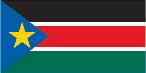
South Sudan’s names conventional long form: the Republic of South Sudan, traditional short form: South Sudan, etymology: self-descriptive name from the country’s former position within Sudan before independence; the term “Sudan” derives from the Arabic “bilad-as-Sudan” meaning “Land of the black [peoples].” Self-descriptive name from the country’s former position within Sudan before independence; The word “Sudan” derives from the Arabic “bilad-as-sudan” meaning “Land of the Black [peoples].”
South Sudan’s terrain is typically plains in the north and center rise to southern highlands along the border with Uganda and Kenya; the White Nile, flowing north out of the uplands of Central Africa, is the prominent geographic feature of the country; The Sudd (a name derived from floating vegetation that hinders navigation) is a large swampy area of more than 100,000 sq km fed by the waters of the White Nile that dominates the center of the country. The country’s mean elevation: N/A, elevation extremes; lowest point: N/A, highest projection: Kinyeti 3,187 m.
The general climate in the country; hot with seasonal rainfall influenced by the annual shift of the Inter-Tropical Convergence Zone: rain heaviest in upland areas of the south and diminishes to the north.
The total number of border countries is 6, Central African Republic 1,055 km, the Democratic Republic of the Congo 714 km, Ethiopia 1,299 km, Kenya 317 km, Sudan 2,158 km, Uganda 475 km. Note: South Sudan-Sudan boundary represents 1 January 1956 alignment are the neighboring nations with the indicated border lengths. South Sudan’s coastline is 0 km (landlocked country), while its marital claims are: none. Waterways: see entry for Sudan. Land use: N/A.
The population in South Sudan 10,204,581 (July 2018 estimate), urban population: 18.8% of total population (2015), central metropolitan area’s population: JUBA (capital) 321,000 (2015), while South Sudan has N/A. Their spoken languages are: English (official language), Arabic (includes Juba and Sudanese variants), regional languages include Dinka, Nuer, Bari, Zande, Shilluk. Main religions in South Sudan are animist, Christian. The nation uses N/A. It is a(n) presidential republic, National holiday(s) Independence Day, 9 July (2011).
Economic overview for the country: Industry and infrastructure in landlocked South Sudan are severely underdeveloped, and poverty is widespread, following several decades of civil war with Sudan. Continued fighting within the new nation is disrupting what remains of the economy. The vast majority of the population is dependent on subsistence agriculture and humanitarian assistance. Property rights are insecure, and price signals are weak, because markets are not well-organized. South Sudan has little infrastructure about 10,000 kilometers of roads, but just 2% of them paved.
Electricity is produced mostly by costly diesel generators, and indoor plumbing and potable water are scarce, so less than 2% of the population has access to electricity. About 90% of consumed goods, capital, and services are imported from neighboring countries mainly Uganda, Kenya and Sudan. Chinese investment plays a growing role in the infrastructure and energy sectors. Nevertheless, South Sudan does have abundant natural resources. South Sudan holds one of the most affluent agricultural areas in Africa, with fertile soils and ample water supplies. Currently the region supports 10-20 million head of cattle.
At independence in 2011, South Sudan produced nearly three-fourths of former Sudan’s total oil output of about a half-million barrels per day. The Government of South Sudan relies on oil for the vast majority of its budget revenues, although oil production has fallen sharply since independence. South Sudan is one of the most oil-dependent countries in the world, with 98% of the government’s annual operating budget and 80% of its gross domestic product (GDP) derived from oil. Oil is exported through a pipeline that runs to refineries and shipping facilities at Port Sudan on the Red Sea. The economy of South Sudan will remain linked to Sudan for some time, given the existing oil infrastructure. The outbreak of conflict in December 2013, combined with falling crude oil production and prices, meant that GDP fell significantly between 2014 and 2017. Since the second half of 2017 oil production has risen, and is currently about 130,000 barrels per day. Poverty and food insecurity has been increased due to displacement of people caused by the conflict. With famine spreading, 66% of the population in South Sudan is living on less than about $2 a day, up from 50.6% in 2009, according to the World Bank. About 80% of the population lives in rural areas, with agriculture, forestry and fishing providing the livelihood for a majority of the households.
Much of rural sector activity is focused on low-input, low-output subsistence agriculture. South Sudan is burdened by considerable debt because of increased military spending and high levels of government corruption. Economic mismanagement is prevalent. Civil servants, including police and the military, are not paid on time, creating incentives to engage in looting and banditry. South Sudan has received more than $11 billion in foreign aid since 2005, mainly from the US, the UK, and the EU. Inflation peaked at over 800% per year in October 2016 but dropped to 118% in 2017. The government has funded its expenditures by borrowing from the central bank and foreign sources, using forward sales of oil as collateral. The central bank’s decision to adopt a managed floating exchange rate regime in December 2015 triggered a 97% depreciation of the currency and spawned a growing black market. Long-term challenges include rooting out public sector corruption, improving agricultural productivity, alleviating poverty and unemployment, improving fiscal transparency – particularly in regard to oil revenues, taming inflation, improving government revenues, and creating a rules-based business environment.
Natural resources of South Sudan: hydropower, fertile agricultural land, gold, diamonds, petroleum, hardwoods, limestone, iron ore, copper, chromium ore, zinc, tungsten, mica, silver.
The main export partners for South Sudan, Africa, are N/A for N/A, while the country’s main import partners are N/A for N/A.
When you visit this country in Africa, consider the natural hazards in South Sudan: N/A, while infectious diseases are a degree of risk: very high food or waterborne disease: bacterial and protozoal diarrhea, hepatitis A and E, and typhoid fever vectorborne disease: malaria, dengue fever, trypanosomiasis-Gambiense (African sleeping sickness)water contact disease: schistosomiasis respiratory disease: meningococcal meningitis animal contact disease: rabies (2016). Also, note that South Sudan faces the following environmental issues: Water pollution, Inadequate supplies of potable water, wildlife conservation and loss of biodiversity, Deforestation, Soil erosion, Desertification, Periodic drought.
You may also be interested in the countries next to South Sudan around its total: 6,018 km border, like the Central African Republic, the Democratic Republic of the Congo, Ethiopia, Kenya, Sudan, Uganda.