Isle of Man (GPS: 54 15 N, 4 30 W) is located in Western Europe, an island in the Irish Sea, between Great Britain and Ireland. The country’s area measurements are total: 572 sq km; land: 572 sq km, water: 0 sq km. This sovereign state is slightly more than three times the size of Washington, DC. The total irrigated land is 0 sq km (2012).
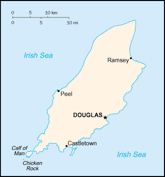
One of the crucial features of Isle of Man: One small islet, the Calf of Man, lies to the southwest and is a bird sanctuary.
It’s significant, and at the same time, the principal city, Douglas’s GPS coordinates are 54 09 N 4 29 W. Douglas’s local time is 5 hours ahead of Washington DC during Standard Time. The capital’s time difference: UTC 0, note; Daylight saving time: +1hr begins last Sunday in March; ends last Sunday in October.
Part of the Norwegian Kingdom of the Hebrides until the 13th century was ceded to Scotland, the isle came under the British crown in 1765. Current concerns include reviving the almost extinct Manx Gaelic language. The Isle of Man is a Crown dependency, which makes it a self-governing possession of the British crown that is not part of the UK. The UK Government, however, remains constitutionally responsible for its defense and international representation.
Isle of Man’s names conventional long form: none, conventional short form: Isle of Manabbreviation: I.O.M., etymology: the name “man” may be derived from the Celtic word for “mountain.” The name “man” may be derived from the Celtic word for “mountain.”
Isle of Man’s terrain is typically hills in north and south bisected by a central valley. The country’s mean elevation: N/A, elevation extremes; lowest point: the Irish Sea 0 m, highest point: Snaefell 621 m.
The country’s general climate is temperate: cool summers and mild winters: overcast about a third of the time.
The total number of border countries is 0; none are the neighboring nations with the indicated border lengths. Isle of Man’s coastline is 160 km, while its marital claims are: territorial sea: 12 nautical miles, exclusive fishing zone: 12 nautical miles. Waterways: N/A. Land use: agricultural land: 74.7%; arable land 43.8%; permanent crops 0%; permanent pasture 30.9%; forest: 6.1%; other: 19.2% (2011 estimate).
The population in Isle of Man 89,407 (July 2018 estimate), urban population: 52.1% of total population (2014), central metropolitan area’s population: DOUGLAS (capital) 29,000 (2014), while the Isle of Man has most people concentrated in cities and large towns of which Douglas, in the southeast, is the largest. Their spoken languages are English, Manx Gaelic (about 2% of the population has some knowledge). The Isle of Man’s main religions is Protestant (Anglican, Methodist, Baptist, Presbyterian, Society of Friends), Roman Catholic. The nation uses the laws of the UK, where applicable, apply, and include Manx statutes. It is a(n) parliamentary democracy (Tynwald); a Crown dependency of the UK, National holiday(s) Tynwald Day, 5 July (1417); date Tynwald Day was first recorded.
Economic overview for the country: Financial services, manufacturing, and tourism are key sectors of the economy. The government offers low taxes and other incentives to high-technology companies and financial institutions to locate on the island; This has paid off in expanding employment opportunities in high-income industries. As a result, agriculture and fishing, once the mainstays of the economy, have declined in their GDP contributions. The Isle of Man also attracts online gambling sites and the film industry. Online gambling sites provided about 10% of the island’s income in 2014. The Isle of Man currently enjoys free access to EU markets, and trade is mostly with the UK. The Isle of Man’s trade relationship with the EU derives from the United Kingdom’s EU membership and will need to be renegotiated in light of the United Kingdom’s decision to withdraw from the bloc. A transition period is expected to allow the free movement of goods and agricultural products to the EU until the end of 2020 or until a new settlement is negotiated.
Natural resources of Isle of Man: none.
Main export partners for the Isle of Man, Europe are N/A for tweeds, herring, processed shellfish, beef, and lamb, while the country’s main import partners are: N/A for timber, fertilizers, fish.
When you visit this country in Europe, consider the Isle of Man’s natural hazards: N/A, while infectious diseases are N/A. Also, note that the Isle of Man faces the following environmental issues: Air pollution, marine pollution, waste disposal (both household and industrial).
You may also be interested in the countries next to the Isle of Man around its 0 km border – No border countries.