Hungary (GPS: 47 00 N, 20 00 E) is located in Central Europe, northwest of Romania. The country’s area measurements are total: 93,028 sq km; land: 89,608 sq km, water: 3,420 sq km. This sovereign state is slightly smaller than Virginia, about the same size as Indiana. The total irrigated land is 1,721 sq km (2012).
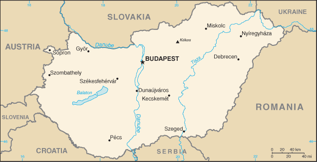
One of the crucial features of Hungary: Landlocked (enclosed or nearly enclosed by land). Strategic location astride main land routes between Western Europe and Balkan Peninsula as well as between Ukraine and the Mediterranean basin. The north-south flowing Duna (Danube) and Tisza Rivers divide the country into three large regions.
It’s significant, and at the same time, the principal city, Budapest’s GPS coordinates are 47 30 N 19 05 E. Budapest’s local time is 6 hours ahead of Washington DC during Standard Time. The capital’s time difference: UTC+1, note; Daylight saving time: +1hr begins last Sunday in March; ends last Sunday in October.
For more information on Hungary, please scroll down below the Google Maps.
Google Maps Hungary and Budapest, Europe
About Hungary in detail
Flag of Hungary
Map of Hungary
Hungary became a Christian kingdom in A.D. 1000 and, for many centuries, served as a bulwark against Ottoman Turkish expansion in Europe. The kingdom eventually became part of the polyglot Austro-Hungarian Empire, which collapsed during World War I. The country fell under communist rule following World War II. In 1956, a revolt and an announced withdrawal from the Warsaw Pact were met with massive military intervention by Moscow. Under the leadership of Janos KADAR in 1968, Hungary began liberalizing its economy, introducing the so-called “Goulash Communism.” Hungary held its first multiparty elections in 1990 and initiated a free market economy. It joined NATO in 1999 and the EU five years later.
Hungary’s names conventional long form: none, conventional short form: Hungary, local long form: none, local short form: Magyarorszag, etymology: the Byzantine Greeks referred to the tribes that arrived on the steppes of Eastern Europe in the 9th century as the “Oungroi,” a name that later Latinized to “Ungri” and which became “Hungari”; the name originally meant an “[alliance of] ten tribes”; the Hungarian name “Magyarorszag” means “Land of the Magyars”; the term may derive from the most prominent of the Hungarian tribes, the Megyer.
Hungary’s terrain is typically flat to rolling plains, hills, and low mountains on the Slovakian border. The country’s mean elevation: 143 m, elevation extremes; lowest point: Tisza River 78 m, highest point: Kekes 1,014 m.
The general climate in the country; temperate: cold, cloudy, humid winters: warm summers.
The total number of border countries is 7, Austria 321 km, Croatia 348 km, Romania 424 km, Serbia 164 km, Slovakia 627 km, Slovenia 94 km, Ukraine 128 km are the neighboring nations with the indicated border lengths. Hungary’s coastline is 0 km (landlocked country), while its marital claims are: none. Waterways: 1,622 km (most on Danube River) (2011). Land use: agricultural land: 58.9%; arable land 48.5%; permanent crops 2%; permanent pasture 8.4%; forest: 22.5%; other: 18.6% (2011 estimate).
The population in Hungary 9,825,704 (July 2018 estimate), urban population: 71.2% of total population (2015), major urban area’s population: BUDAPEST (capital) 1.714 million (2015), while Hungary has a fairly even distribution throughout most of the country, with urban areas attracting larger and denser populations. Their spoken languages are: Hungarian (official language) 99.6%, English 16%, German 11.2%, Russian 1.6%, Romanian 1.3%, French 1.2%, other 4.2%. Note shares sum to more than 100% because some respondents gave more than one answer on the census; Hungarian is the mother tongue of 98.9% of Hungarian speakers (2011 estimate). Main religions in Hungary are Roman Catholic 37.2%, Calvinist 11.6%, Lutheran 2.2%, Greek Catholic 1.8%, other 1.9%, none 18.2%, unspecified 27.2% (2011 estimate). The nation uses a civil legal system influenced by the German model. It is a(n) parliamentary republic, National holiday(s) Saint Stephen’s Day, 20 August.
Economic overview for the country: Hungary has transitioned from a centrally planned to a market-driven economy with a per capita income approximately two-thirds of the EU-28 average; However, in recent years, the government has become more involved in managing the economy. Budapest has implemented unorthodox economic policies to boost household consumption and has relied on EU-funded development projects to generate growth. Following the fall of communism in 1990, Hungary experienced a drop-off in exports and financial assistance from the former Soviet Union.
Hungary embarked on a series of economic reforms, including privatizing state-owned enterprises, reducing social spending programs, shifting from a centrally planned to a market-driven economy, and reorienting its economy towards trade with the Westimate. These efforts helped spur growth, attract investment, and reduce Hungary’s debt burden and fiscal deficits. Despite these reforms, the average Hungarian living conditions initially deteriorated as inflation increased and unemployment reached double digits. Conditions slowly improved over the 1990s as the reforms came to fruition, and export growth accelerated. Economic policies instituted during that decade helped position Hungary to join the European Union in 2004. Hungary has not yet joined the euro-zone. Hungary suffered a historic economic contraction due to the global economic slowdown in 2008-2009 as export demand and domestic consumption dropped, prompting it to take an IMF-EU financial assistance package. Since 2010, the government has backpedaled on many economic reforms and took a more populist economic management approach.
The government has favored national industries and government-linked businesses through legislation, regulation, and public procurements. In 2011 and 2014, Hungary nationalized private pension funds, which squeezed financial service providers out of the system and helped Hungary curb its public debt and lower its budget deficit to below 3% of GDP, as subsequent pension contributions have been channeled into the state-managed pension fund. Hungary’s public debt (at 74.5% of GDP) is still high compared to EU peers in Central Europe. Real GDP growth has been robust in the past few years due to increased EU funding, higher EU demand for Hungarian exports, and a rebound in domestic household consumption.
To further boost household consumption ahead of the 2018 election, the government embarked on a six-year phased increase to minimum wages and public sector salaries, decreased taxes on foodstuffs and services, cut the personal income tax from 16% to 15%, and implemented a uniform 9% business tax for small and medium-sized enterprises and large companies. Real GDP growth slowed in 2016 due to a cyclical decrease in EU funding but increased to 3.8% in 2017 as the government pre-financed EU funded projects ahead of the 2018 election. Systemic economic challenges include pervasive corruption, labor shortages driven by demographic declines and migration, widespread poverty in rural areas, vulnerabilities to changes in demand for exports, and a heavy reliance on Russian energy imports.
Main export partners for Hungary, Europe are Germany 28%, Romania 5.4%, Slovakia 5.1%, Austria 5%, Italy 4.8%, France 4.7%, UK 4%, Czech Republic 4% (2015) for machinery and equipment 53.5%, other manufactures 31.2%, food products 8.7%, raw materials 3.4%, fuels and electricity 3.9% (2012 estimate), while the main import partners for the country are: Germany 25.8%, China 6.7%, Austria 6.6%, Poland 5.5%, Slovakia 5.3%, France 5%, Czech Republic 4.8%, Netherlands 4.6%, Italy 4.5% (2015) for machinery and equipment 45.4%, other manufactures 34.3%, fuels and electricity 12.6%, food products 5.3%, raw materials 2.5% (2012).
When you visit this country in Europe, consider the natural hazards in Hungary: N/A, while infectious diseases are a degree of risk: intermediate vector-borne diseases: tickborne encephalitis (2016). Also, note that Hungary faces the following environmental issues: Air and water pollution are some of Hungary’s most serious environmental problems. Water quality in the Hungarian part of the Danube has improved but is still plagued by pollutants from industry and large-scale agriculture, Soil pollution.
You may also be interested in the countries next to Hungary around its total 2,106 km border, like Austria, Croatia, Romania, Serbia, Slovakia, Slovenia, Ukraine.