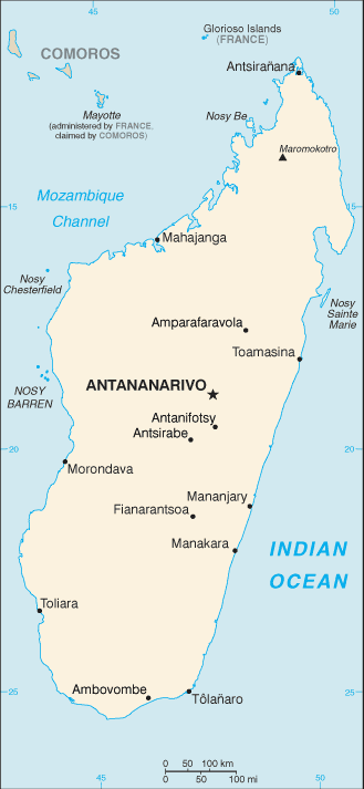
Madagascar (GPS: 20 00 S, 47 00 E) located in Southern Africa, an island in the Indian Ocean, east of Mozambique. The country’s area measurements are total: 587,041 sq km; land: 581,540 sq km, water: 5,501 sq km. This sovereign state is slightly less than twice the size of Arizona. The total irrigated land is 10,860 sq km (2012).
One of the essential features of Madagascar: World’s fourth-largest island. Strategic location along the Mozambique Channel. Despite Madagascar’s proximity to the African continent, ocean currents isolate the island, resulting in high endemic plant and animal species rates. Approximately 90% of flora and fauna on the island found nowhere else.
It’s significant, and at the same time, the principal city, Antananarivo’s GPS coordinates are 18 55 S 47 31 E. Antananarivo’s local time is 8 hours ahead of Washington DC during Standard Time. The capital’s time difference: UTC+3.
Madagascar was one of the last major habitable landmasses on earth settled by humans. While some short visits to the island may have occurred in the centuries B.C., large-scale settlement began between A.D. 350 and 550 with settlers from present-day Indonesia. The island attracted Arab and Persian traders as early as the 7th century, and migrants from Africa arrived around A.D. 1000. Madagascar was a pirate stronghold during the late 17th and early 18th centuries and served as a slave-trading center into the 19th century. From the 16th to the late 19th century, a native Merina Kingdom dominated much of Madagascar. The French conquered the island in 1896, which made it a colony; Independence regained in 1960.
During 1992-93, free presidential and National Assembly elections were held, ending 17 years of single-party rule. In 1997, in the second presidential race, Didier RATSIRAKA, the leader during the 1970s and 1980s, returned to the presidency. The 2001 presidential election was contested between the followers of Didier RATSIRAKA and Marc RAVALOMANANA, nearly causing secession of half of the country. In 2002, the High Constitutional Court announced RAVALOMANANA the winner.
RAVALOMANANA won a second term in 2006 but, following protests in 2009, handed over power to the military, which then conferred the presidency on the mayor of Antananarivo, Andry RAJOELINA, in what amounted to a coup d’etat. Following a lengthy mediation process led by the Southern African Development Community, Madagascar held UN-supported presidential and parliamentary elections in 2013. Former de facto finance minister Hery RAJAONARIMAMPIANINA won a runoff election in December 2013 and inaugurated in January 2014. In January 2019, RAJOELINA declared a runoff election against RAVALOMANANA; Both RATSIRAKA and RAJAONARIMAMPIANINA also ran in the first round of the election, which took place in November 2018.
Madagascar’s names conventional long form: the Republic of Madagascar, traditional short form: Madagascar, local long form: Republique de Madagascar/Repoblikan’i Madagasikara, local transient state: Madagascar/Madagasikara, former: Malagasy Republic. Note: the name “Madagascar” was first used by the 13th-century Venetian explorer Marco POLO as a corrupted transliteration of Mogadishu; the Somali port POLO confused the island. The name “Madagascar” was first used by the 13th-century Venetian explorer Marco POLO as a corrupted transliteration of Mogadishu, the Somali port with which POLO confused the island.
Madagascar’s terrain is typically narrow coastal plain, high plateau, and mountains in the center. The country’s mean elevation: 615 m, elevation extremes; lowest point: Indian Ocean 0 m, highest point: Maromokotro 2,876 m.
The country’s general climate, tropical along the coast, temperate inland, arid in the south.
The total number of border countries is 0. None are the neighboring nations with the indicated border lengths. Madagascar’s coastline is 4,828 km. Its marital claims are territorial sea: 12 nautical miles, contiguous zone: 24 nautical miles, exclusive economic zone: 200 nautical miles, continental shelf: 200 nautical miles or 100 nautical miles from the 2,500-m isobath. Waterways: 600 km (432 km navigable) (2011). Land use: agricultural land: 71.1%; arable land 6%; permanent crops 1%; permanent pasture 64.1%; forest: 21.5%; other: 7.4% (2011 estimate).
The population in Madagascar 25,683,610 (July 2018 estimate), urban population: 35.1% of total population (2015), major urban area’s population: ANTANANARIVO (capital) 2.61 million (2015), while Madagascar has N/A. Their spoken languages are French (official language), Malagasy (official language), English. The main religions in Madagascar are Christian, indigenous believers, Muslims. Note: population largely practices Christianity or an indigenous religion; a small share of the population is Muslim. The nation uses civil law system based on the old French civil code and customary law in marriage, family, and obligation matters. It is a(n) semi-presidential republic, National holiday(s) Independence Day, 26 June (1960).
Economic overview for the country: Madagascar is a mostly unregulated economy with many untapped natural resources but no capital markets, a weak judicial system, poorly enforced contracts, and rampant government corruption. The country faces challenges to improve education, healthcare, and the environment to boost long-term economic growth. Agriculture, including fishing and forestry, is a mainstay of the economy, accounting for more than one-fourth of GDP and employing roughly 80% of the population. Deforestation and erosion, aggravated by bushfires, slash-and-burn clearing techniques, and firewood as the primary fuel source, are serious concerns to the agriculture-dependent economy. After discarding socialist economic policies in the mid-1990s, Madagascar followed a World Bank- and IMF-led policy of privatization and liberalization until a 2009 coup d’état led many nations, including the United States, to suspend non-humanitarian aid until a democratically-elected president was inaugurated in 2014.
The pre-coup strategy had placed the country on a slow and steady growth path from a shallow starting point. Exports of apparel boomed after gaining duty-free access to the US market in 2000 under the African Growth and Opportunity Act (AGOA); However, Madagascar’s failure to comply with the requirements of the AGOA led to the termination of the country’s duty-free access in January 2010, a sharp fall in textile production, a loss of more than 100,000 jobs, and a GDP drop of nearly 11%.
Madagascar regained AGOA access in January 2015, and ensuing growth has been slow and fragile. Madagascar produces around 80% of the world’s vanilla, and its reliance on this commodity for most of its foreign exchange is a significant source of vulnerability. Economic reforms have been modest, and the country’s financial sector remains weak, limiting monetary policy to control inflation. An ongoing IMF program aims to strengthen financial and investment management capacity.
Natural resources of Madagascar: graphite, chromite, coal, bauxite, rare earth elements, salt, quartz, tar sands, semiprecious stones, mica, fish, hydropower.
Main export partners for Madagascar, Africa are France 15.2%, US 12.7%, China 7.1%, South Africa 5.9%, Japan 5.5%, Netherlands 5.4%, Germany 5.1%, Belgium 5%, India 4.4% (2015) for coffee, vanilla, shellfish, sugar, cotton cloth, clothing, chromite, petroleum products, while the main import partners for the country are: China 24.8%, France 10.3%, Bahrain 5.6%, India 5.5%, Kuwait 4.5%, Mauritius 4.5%, South Africa 4.3% (2015) for capital goods, petroleum, consumer goods, food.
When you visit this country in Africa, consider the natural hazards in Madagascar: Periodic cyclones, drought, and locust infestation volcanism: Madagascar’s volcanoes have not erupted in historical times, while infectious diseases are a degree of risk: very high food or waterborne diseases: bacterial diarrhea, hepatitis A, and typhoid fever vectorborne diseases: malaria and dengue fever water contact disease: schistosomiasis animal contact disease: rabies (2016). Also, note that Madagascar faces the following environmental issues: Erosion and soil degradation results from deforestation and overgrazing, Desertification, Agricultural fires, Surface water contaminated with raw sewage and other organic wastes, wildlife preservation (endangered species of flora and fauna unique to the island).
You may also be interested in Madagascar’s surrounding countries around its 0 km border – No border countries.