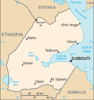
Djibouti (GPS: 11 30 N, 43 00 E) is located in Eastern Africa, bordering the Gulf of Aden and the Red Sea, between Eritrea and Somalia. The country’s area measurements are total: 23,200 sq km; land: 23,180 sq km, water: 20 sq km. This sovereign state is slightly smaller than New Jersey. The total irrigated land is 10 sq km (2012).
Djibouti’s important features are strategic location near the world’s busiest shipping lanes and close to Arabian oilfields. The terminus of rail traffic into Ethiopia. Mostly wasteland. Lac Assal (Lake Assal) is the lowest point in Africa and the world’s saltiest lake.
It’s significant, and simultaneously, the principal city, Djibouti’s GPS coordinates are 11 35 N 43 09 E. Djibouti’s local time is 8 hours ahead of Washington DC during Standard Time. The capital’s time difference: UTC+3.
The French Territory of the Afars and the Issas became Djibouti in 1977. Hassan Gouled APTIDON installed an authoritarian one-party state and proceeded to serve as president until 1999. Unrest among the Afar minority during the 1990s led to a civil war that ended in 2001 with a peace accord between Afar rebels and the Somali Issa-dominated government. In 1999, Djibouti’s first multiparty presidential election resulted in the election of Ismail Omar GUELLEH as president; He was re-elected to a second term in 2005 and extended his tenure in office via a constitutional amendment, which allowed him to serve a third term in 2011 and begin a fourth term in 2016. Djibouti occupies a strategic geographic location at the intersection of the Red Sea and the Gulf of Aden. Its ports handle 95% of Ethiopia’s trade. Djibouti’s ports also service transshipments between Europe, the Middle East, and Asia. The government holds longstanding ties to France, which maintains a military presence in the country, as does the US, Japan, Italy, Germany, Spain, and China.
Djibouti’s names conventional long form: Republic of Djibouti, conventional short form: Djibouti, local long form: Republique de Djibouti/Jumhuriyat Jibuti, local short form: Djibouti/Jibuti, former: French Territory of the Afars and Issas, French Somaliland, etymology: the country name derives from the capital city of Djibouti.
Djibouti’s terrain is typically coastal plain and plateau separated by central mountains. The country’s mean elevation: 430 m, elevation extremes; lowest point: Lac Assal -155 m, highest point: Moussa Ali 2,028 m.
The general climate in the country; desert: torrid, dry.
The total number of border countries is 3, Eritrea 125 km, Ethiopia 342 km, Somalia 61 km are the neighboring nations with the indicated border lengths. Djibouti’s coastline is 314 km, while its marital claims are: territorial sea: 12 nautical miles, contiguous zone: 24 nautical miles, exclusive economic zone: 200 nautical miles. Waterways: N/A. Land use: agricultural land: 73.4%; arable land 0.1%; permanent crops 0%; permanent pasture 73.3%; forest: 0.2%; other: 26.4% (2011 estimate).
The population in Djibouti 884,017 (July 2018 estimate), urban population: 77.3% of total population (2015), major urban area’s population: DJIBOUTI (capital) 529,000 (2015), while Djibouti has N/A. Their spoken languages are French (official language), Arabic (official language), Somali, Afar. The main religions in Djibouti are Muslim 94%, Christian 6%. The nation uses a mixed legal system based primarily on the French civil code (as it existed in 1997), Islamic religious law (in matters of family law and successions), and customary law. It is a(n) semi-presidential republic, National holiday(s) Independence Day, 27 June (1977).
Economic overview for the country: Djibouti’s economy is based on service activities connected with its strategic location as a deepwater port on the Red Sea. Three-fourths of Djibouti’s inhabitants live in the capital city; The remainder is mostly nomadic herders. Scant rainfall and less than 4% arable land limit crop production to small quantities of fruits and vegetables, and most food must be imported. Djibouti provides services as both a transit port for the region and an international transshipment and refueling center. Imports, exports, and re-exports represent 70% of port activity at Djibouti’s container terminal. Reexports consist primarily of coffee from landlocked neighbor Ethiopia.
Djibouti has few natural resources and little industry. Therefore, the nation is heavily dependent on foreign assistance to support its balance of payments and finance development projects. An official unemployment rate of nearly 40% – with youth unemployment near 80% – continues to be a significant problem. Inflation was a modest 3% in 2014-2017, due to low international food prices and a decline in electricity tariffs. Djibouti’s reliance on diesel-generated electricity and imported food and water leave average consumers vulnerable to global price shocks, though, in mid-2015, Djibouti passed new legislation to liberalize the energy sector. The government has emphasized infrastructure development for transportation and energy, and Djibouti, with foreign partners’ help, particularly China, has begun to increase and modernize its port capacity.
In 2017, Djibouti opened two of the largest projects in its history, the Doraleh Port and Djibouti-Addis Ababa Railway, funded by China as part of the “Belt and Road Initiative,” which will increase the country’s ability to capitalize on its strategic location.
Main export partners for Djibouti, Africa are Somalia 79.8%, US 5.4%, Yemen 4.6%, UAE 4% (2015) for re-exports, hides, and skins, coffee (in transit), scrap metal, while the main import partners for the country are: China 42.1%, Saudi Arabia 14.3%, Indonesia 5.9%, India 4.4% (2015) for foods, beverages, transport equipment, chemicals, petroleum products, clothing.
When you visit this country in Africa, consider the natural hazards in Djibouti: Earthquakes, droughts, occasional cyclonic disturbances from the Indian Ocean bring heavy rains and flash floods. Volcanism: experiences limited volcanic activity, Ardoukoba (elevation 298 m) last erupted in 1978, Manda-Inakir, located along the Ethiopian border, is also historically active, while infectious diseases are the degree of risk: high food or waterborne diseases: bacterial and protozoal diarrhea, hepatitis A, and typhoid fever vectorborne disease: dengue fever (2016). Also, note that Djibouti faces the following environmental issues: Inadequate supplies of potable water, water pollution, Limited arable land, Deforestation (forests threatened by agriculture and the use of wood for fuel), Desertification, Endangered species.
You may also be interested in the countries next to Djibouti around its total: 528 km border, like Eritrea, Ethiopia, Somalia.