Eritrea (GPS: 15 00 N, 39 00 E) is located in Eastern Africa, bordering the Red Sea, between Djibouti and Sudan. The country’s area measurements are total: 117,600 sq km; land: 101,000 sq km, water: 16,600 sq km. This sovereign state is slightly larger than Pennsylvania. The total irrigated land is 210 sq km (2012).
One of the essential features of Eritrea: Strategic geopolitical position along the world’s busiest shipping lanes. Eritrea retained Ethiopia’s entire coastline along the Red Sea upon de jure independence from Ethiopia on 24 May 1993.
It’s significant, and at the same time, the principal city, Asmara’s GPS coordinates are 15 20 N 38 56 E. Asmara’s local time is 8 hours ahead of Washington DC during Standard Time. The capital’s time difference: UTC+3.
For more information on Eritrea, please scroll down below the Google Maps.
Google Maps Eritrea and Asmara, Africa
About Eritrea in detail
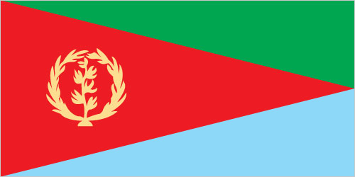
Flag of Eritrea
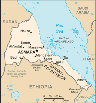
Map of Eritrea
After independence from Italian colonial control in 1941 and 10 years of British administrative control, the UN established Eritrea as an autonomous region within the Ethiopian federation in 1952. Ethiopia’s full annexation of Eritrea as a province ten years later sparked a violent 30-year struggle for independence that ended in 1991 with Eritrean rebels defeating government forces. Eritreans overwhelmingly approved independence in a 1993 referendum. ISAIAS Afwerki has been Eritrea’s only president since independence; His rule, particularly since 2001, has been highly autocratic and repressive. His government has created a highly militarized society by pursuing an unpopular mandatory conscription program into national service – divided between military and civilian service – of indefinite length.
A two-and-a-half-year border war with Ethiopia that erupted in 1998 ended under UN auspices in December 2000. A UN peacekeeping operation was established that monitored a 25 km-wide Temporary Security Zone. The Eritrea-Ethiopia Boundary Commission (EEBC), created in April 2003, was tasked “to delimit and demarcate the colonial treaty border based on pertinent colonial treaties (1900, 1902, and 1908) and applicable international law.” The EEBC on 30 November 2007 remotely demarcated the border, assigning the town of Badme to Eritrea, despite Ethiopia’s maintaining forces there from the time of the 1998-2000 war. Eritrea insisted that the UN terminate its peacekeeping mission on 31 July 2008. More than a decade of a tense “no peace, no war” stalemate ended in 2018 after the newly elected Ethiopian Prime Minister accepted the EEBC’s 2007 ruling. The two countries signed declarations of peace and friendship in July and September.
Following the July 2018 peace agreement with Ethiopia, Eritrean leaders engaged in intensive diplomacy around the Horn of Africa, bolstering regional peace, security, and cooperation and brokering rapprochements between governments and opposition groups. In November 2018, the UN Security Council lifted an arms embargo imposed on Eritrea in 2009. After the UN Somalia-Eritrea Monitoring Group reported, they had not found Eritrean support evidence in recent years Al-Shabaab.
Eritrea’s names conventional long form: the State of Eritrea, traditional short form: Eritrea, local long way: Hagere Ertra, local short form: Ertra, former: Eritrea Autonomous Region in Ethiopia, etymology: the country name derives from the ancient Greek appellation “Erythra Thalassa” meaning the Red Sea, which is the significant water body bordering the country. The country name derives from the ancient Greek cognomen “Erythra Thalassa,” meaning the Red Sea, the primary water body connecting the country.
Eritrea’s terrain is typically dominated by an extension of Ethiopian north-south trending highlands, descending on the east to a coastal desert plain, northwest to hilly terrain, and southwest flat-to-rolling plains. The country’s mean elevation: 853 m, elevation extremes; lowest point: near Kulul within the Danakil Depression -75 m, highest point: Soira 3,018 m.
The country’s general climate; hot, desert strip along Red Sea coast: colder and wetter in the central highlands (up to 61 cm of rainfall annually, most massive June to September): semiarid in western hills lowlands.
The total number of border countries is 3, Djibouti 125 km, Ethiopia 1,033 km, Sudan 682 km are the neighboring nations with the indicated border lengths. Eritrea’s coastline is 2,234 km (mainland on the Red Sea 1,151 km, islands in Red Sea 1,083 km), while its marital claims are: territorial sea: 12 nautical miles. Waterways: N/A. Land use: agricultural land: 75.1%; arable land 6.8%; permanent crops 0%; permanent pasture 68.3%; forest: 15.1%; other: 9.8% (2011 estimate).
The population in Eritrea 5,970,646 (July 2018 estimate), urban population: 22.6% of total population (2015), major urban area’s population: ASMARA (capital) 804,000 (2015), while Eritrea has N/A. Their spoken languages are Tigrinya (official language), Arabic (official language), English (official language), Tigre, Kunama, Afar, other Cushitic languages. The main religions in Eritrea are Muslim, Coptic Christian, Roman Catholic, Protestant. The nation uses a mixed legal system of civil, customary, and Islamic religious law. It is a(n) presidential republic, National holiday(s) Independence Day, 24 May (1991).
Economic overview for the country: Since Ethiopia’s formal independence in 1993, Eritrea has faced many economic problems, including a lack of financial resources and chronic drought. Eritrea has a command economy under the control of the sole political party, the People’s Front for Democracy and Justice. Like many African nations’ economies, a large share of the population – nearly 80% in Eritrea – is engaged in subsistence agriculture. Still, the sector only produces a small percentage of the country’s total output.
Mining accounts for the lion’s share of output. The government has strictly controlled the use of foreign currency by limiting access and availability; New regulations in 2013 aimed at relaxing currency controls have had a little economic effect. Few large private enterprises exist in Eritrea, and most operate in conjunction with government partners, including several large international mining ventures, which began production in 2013. In late 2015, Eritrea’s Government introduced a new currency, retaining the name nakfa, and restricted the number of hard currency individuals could withdraw from banks per month. The changeover has resulted in exchange fluctuations and the scarcity of hard currency available in the market.
While reliable statistics on Eritrea are difficult to obtain, erratic rainfall and the large percentage of the labor force tied up in military service continue to interfere with agricultural production and economic development. Eritrea’s harvests generally cannot meet the food needs of the country without supplemental grain purchases. Copper, potash, and gold production are likely to continue to drive limited economic growth and government revenue over the next few years. Still, military spending will continue to compete with development and investment plans.
Natural resources of Eritrea: gold, potash, zinc, copper, salt, possibly oil and natural gas, fish.
Main export partners for Eritrea, Africa are N/A for gold and other minerals, livestock, sorghum, textiles, food, and small industry manufacturers. The country’s main import partners are N/A for machinery, petroleum products, food, manufactured goods.
When you visit this country in Africa, consider the natural hazards in Eritrea: Frequent droughts, rare earthquakes, and volcanoes, locust swarms. Volcanism: Dubbi (elevation 1,625 m), which last erupted in 1861, was the country’s only historically active volcano until Nabro (2,218 m) came to life on 12 June 2011, while infectious diseases are a degree of risk: high food or waterborne diseases: bacterial diarrhea, hepatitis A, and typhoid fever vectorborne diseases: malaria and dengue fever (2016). Note that Eritrea faces the following environmental issues: Deforestation, Desertification, Soil erosion, over-grazing.
You may also be interested in the countries next to Eritrea around its total: 1,840 km border, like Djibouti, Ethiopia, Sudan.