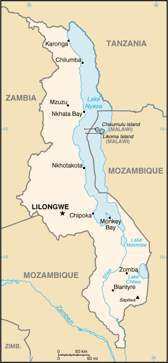
Malawi (GPS: 13 30 S, 34 00 E) is located in Southern Africa, east of Zambia, west, and north of Mozambique. The country’s area measurements are total: 118,484 sq km; land: 94,080 sq km, water: 24,404 sq km. This sovereign state is slightly smaller than Pennsylvania. The total irrigated land is 740 sq km (2012).
One of the essential features of Malawi: Landlocked (enclosed or nearly enclosed by land). Lake Nyasa, some 580 km long, is the country’s most prominent physical feature. It contains more fish species than any other lake on earth.
It’s significant, and at the same time, the principal city, Lilongwe’s GPS coordinates are 13 58 S 33 47 E. Lilongwe’s local time is 7 hours ahead of Washington DC during Standard Time. The capital’s time difference: UTC+2.
For more information on Malawi, please scroll down below the Google Maps.
Google Maps Malawi and Lilongwe, Africa
About Malawi in detail
Flag of Malawi
Map of Malawi
Established in 1891, the British protectorate of Nyasaland became the independent nation of Malawi in 1964. After three decades of one-party rule under President Hastings Kamuzu BANDA, the country held multiparty presidential and parliamentary elections in 1994, under a provisional constitution that came into full effect the following year. Bakili MULUZI became the first freely elected president of Malawi when he won the presidency in 1994; He won re-election in 1999.
President Bingu wa MUTHARIKA, elected in 2004 after a failed attempt by the previous president to amend the constitution to permit another term, struggled to assert his authority against his predecessor and subsequently started his party, the Democratic Progressive Party, in 2005. MUTHARIKA was reelected to a second term in 2009. He oversaw some economic improvement in his first term but was accused of financial mismanagement and poor governance in his second term. He died abruptly in 2012 and was succeeded by the vice president Joyce BANDA, who had earlier started her party, the People’s Party. MUTHARIKA’s brother, Peter MUTHARIKA, defeated BANDA in the 2014 election. Population growth, increasing pressure on agricultural lands, corruption, and the scourge of HIV/AIDS pose major problems for Malawi.
Malawi’s names conventional long form: the Republic of Malawi, traditional short form: Malawi, local long form: Dziko la Malawi, local short form: Malawi, former: British Central African Protectorate, Nyasaland Protectorate, Nyasaland, etymology: named for the East African Maravi kingdom of the 16th century; the word “maravi” means “fire flames.” Named for the East African Maravi Kingdom of the 16th century; The term “maravi” means “fire flames.”
Malawi’s terrain is typically a narrow, elongated plateau with rolling plains, rounded hills, some mountains. The country’s mean elevation: 779 m, elevation extremes; lowest point: junction of the Shire River and international boundary with Mozambique 37 m, highest point: Sapitwa 3,002 m.
The country’s general climate is sub-tropical: rainy season (November to May): the dry season (May to November).
The total number of border countries is 3, Mozambique 1,498 km, Tanzania 512 km, Zambia 847 km are the neighboring nations with the indicated border lengths. Malawi’s coastline is 0 km (landlocked country), while its marital claims are: none. Waterways: 700 km (on Lake Nyasa [Lake Malawi] and Shire River) (2010). Land use: agricultural land: 59.2%; arable land 38.2%; permanent crops 1.4%; permanent pasture 19.6%; forest: 34%; other: 6.8% (2011 estimate).
The population in Malawi 19,842,560 (July 2018 estimate), urban population: 16.3% of total population (2015), major urban area’s population: LILONGWE (capital) 905,000; Blantyre-Limbe 808,000 (2015), while Malawi has N/A. Their spoken languages are English (official language), Chichewa (common), Chinyanja, Chiyao, Chitumbuka, Chilomwe, Chinkhonde, Chingoni, Chisena, Chitonga, Chinyakyusa, Chilambya. Main religions in Malawi are Christian 82.6%, Muslim 13%, other 1.9%, none 2.5% (2008 estimate). The nation uses mixed legal system of English common law and customary law; judicial review of legislative acts in the Supreme Court of Appeal. It is a(n) presidential republic, National holiday(s) Independence Day (Republic Day), 6 July (1964).
Economic overview for the country: Landlocked Malawi ranks among the world’s least developed countries. The country’s financial performance has historically been constrained by policy inconsistency, macroeconomic instability, poor infrastructure, rampant corruption, high population growth, and poor health and education outcomes that limit labor productivity. The economy is predominately agricultural, with about 80% of the population living in rural areas.
Agriculture accounts for about one-third of GDP and 80% of export revenues. The tobacco sector’s performance is key to short-term growth as tobacco accounts for more than half of exports. However, Malawi is looking to diversify away from tobacco to other cash crops. The economy depends on substantial inflows of economic assistance from the IMF, the World Bank, and individual donor nations. Donors halted direct budget support from 2013 to 2016 because of concerns about corruption and fiscal carelessness, but the World Bank resumed budget support in May 2017. In 2006, Malawi was approved for relief under the Heavily Indebted Poor Countries (HIPC) program. Recent increases in domestic borrowing mean that debt servicing in 2016 exceeded the levels before HIPC debt relief. Heavily dependent on rain-fed agriculture, with corn being the staple crop, Malawi’s economy was hit hard by the El Nino-driven drought in 2015 and 2016 and now faces a threat from the fall armyworm.
The drought also slowed economic activity, led to two consecutive years of declining economic growth and high inflation rates. Depressed food prices over 2017 led to a significant drop in inflation (from an average of 21.7% in 2016 to 12.3% in 2017), with a similar reduction in interest rates.
Natural resources of Malawi: limestone, arable land, hydropower, unexploited deposits of uranium, coal, and bauxite.
Main export partners for Malawi, Africa are Belgium 15.8%, Zimbabwe 12%, India 6.9%, South Africa 6.2%, US 6%, Russia 5.6%, Germany 4.6% (2015) for tobacco 53%, tea, sugar, cotton, coffee, peanuts, wood products, apparel (2010 estimate), while the main import partners for the country are: South Africa 26.4%, China 16.7%, India 12%, Zambia 10.3%, Tanzania 6% (2015) for food, petroleum products, semi-manufactures, consumer goods, transportation equipment.
When you visit this country in Africa, consider the natural hazards in Malawi: N/A, while infectious diseases are a degree of risk: very high food or waterborne diseases: bacterial and protozoal diarrhea, hepatitis A, and typhoid fever vectorborne diseases: malaria and dengue fever water contact disease: schistosomiasis animal contact disease: rabies (2016). Also, note that Malawi faces the following environmental issues: Deforestation, Land degradation, water pollution from agricultural runoff, sewage, industrial wastes, Siltation of spawning grounds endangers fish populations, Negative effects of climate change (too high temperatures, changing precipitation patterns).
You may also be interested in the countries next to Malawi around its total: 2,857 km border, like Mozambique, Tanzania, Zambia.