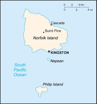
Norfolk Island (GPS: 29 02 S, 167 57 E) is located in Oceania, an island in the South Pacific Ocean, east of Australia. The country’s area measurements are total: 36 sq km; land: 36 sq km, water: 0 sq km. This sovereign state is about 0.2 times the size of Washington, DC. The total irrigated land is 0 sq km (2012).
One of the crucial features of Norfolk Island: Most of the 32 km coastline consists of almost inaccessible cliffs, but the land slopes down to the sea in one small southern area on Sydney Bay, where the capital of Kingston is situated.
It’s significant, and at the same time, the principal city, Kingston’s GPS coordinates are 29 03 S 167 58 E. Kingston’s local time is 16 hours ahead of Washington DC during Standard Time. The capital’s time difference: UTC+11.
Two British attempts at establishing the island as a penal colony (1788-1814 and 1825-1855) were ultimately abandoned. In 1856, the island was resettled by Pitcairn Islanders, descendants of the Bounty mutineers and their Tahitian companions.
Norfolk Island’s names conventional long form: Territory of Norfolk Island, conventional short form: Norfolk Island, etymology: named by British explorer Captain James COOK after Mary HOWARD, Duchess of Norfolk, in 1774.
Norfolk Island’s terrain is typically volcanic island with mostly rolling plains. The country’s mean elevation: N/A, elevation extremes; lowest point: Pacific Ocean 0 m, highest point: Mount Bates 319 m.
The general climate in the country; subtropical: mild, with little seasonal temperature variation.
The total number of border countries is 0; none are the neighboring nations with the indicated border lengths. Norfolk Island’s coastline is 32 km, while its marital claims are: territorial sea: 12 nautical miles, exclusive fishing zone: 200 nautical miles. Waterways: N/A. Land use: agricultural land: 25%; arable land 0%; permanent crops 0%; permanent pasture 25%; forest: 11.5%; other: 63.5% (2011 estimate).
The population in Norfolk Island 1,748 (2016 estimate), N/A, major urban area’s population: N/A, while Norfolk Island has N/A. Their spoken languages are: English (official language) 67.6%, other 32.4% (includes Norfolk Island 23.7%, which is a mixture of 18th century English and ancient Tahitian) (2011 estimate). Main religions in Norfolk Island are Protestant 49.6% (Anglican 31.8%, Uniting Church in Australia 10.6%, Seventh Day Adventist 3.2%), Roman Catholic 11.7%, other 8.6%, none 23.5%, unspecified 6.6% (2011 estimate). The nation uses English common law and the laws of Australia. It is a(n) parliamentary democracy (formerly the Legislative Assembly); overseas territory of Australia; note – in May 2015, the Australian Parliament passed the Norfolk Island Legislation Amendment Bill 2015, which abolished Norfolk Island self-government and replaced it with an interim Advisory Council effective 1 July 2015, National holiday(s) Bounty Day (commemorates the arrival of Pitcairn Islanders), 8 June (1856).
Economic overview for the country: Norfolk Island is suffering from a severe economic downturn. Tourism, the primary economic activity, is the main driver of economic growth. The agricultural sector has become self-sufficient in the production of beef, poultry, and eggs.
Natural resources of Norfolk Island: fish.
Main export partners for Norfolk Island, Oceania are N/A for postage stamps, seeds of the Norfolk Island pine and Kentia palm, small quantities of avocados, while the main import partners for the country are: N/A for N/A.
When you visit this country in Oceania, consider the natural hazards in Norfolk Island: Typhoons (mostly May to July), while infectious diseases are N/A. Also, note that Norfolk Island faces the following environmental issues: Inadequate solid waste management, Most freshwater obtained through rainwater catchment, Preservation of a unique ecosystem.
You may also be interested in the countries next to Norfolk Island around its 0 km border – No border countries.