Google Maps is a must-have for any traveler, and with the release of the updated version of Google Maps, it’s even more essential. With all the new features and enhancements, one of the best features is that it evolves on you! If you’re looking for something specific – like a restaurant that was closed last night but is now open – Google Maps will be able to show you right where it is. And if there are any changes or updates to the information, Google Maps will let you know right away.
Google Maps and Street View are undergoing a significant transformation again.
Google celebrates the 15th anniversary of Google Maps Street View, with more than 220 billion images taken in 100+ countries worldwide. The occasion has given them an excellent opportunity to announce a series of welcome new features.
One of the exciting innovations concerns the cameras themselves, which will soon undergo a significant weight loss. According to the company, the new cameras will be significantly lighter and smaller than the devices currently in use, which will be suitable for users because they will be able to take Street View images in hard-to-reach places. This could include narrow streets, forest-mountain paths, etc., while image quality is expected to remain unchanged.
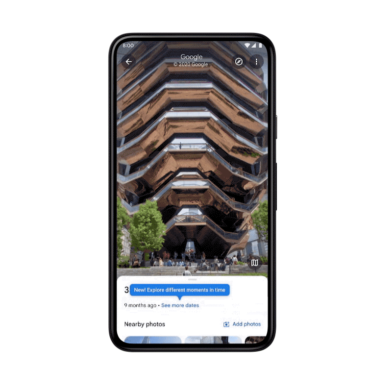
In theory, all you’ll need is to tap on the ‘more dates’ button at the bottom of the image in Street View, then select the date you want to travel back to from the pop-up menu. And that means we can hunt down bizarre old Street View images from our mobile phones in our boredom or even revisit the classics.
In theory, it should have gone live this week, but users in some countries may receive the update a little later.
The best Street View feature will be available on mobile!
Street View is one of the best features on Google Maps, and it’s getting better all the time. Several years ago, Google added a new feature to Street View – mobile Street View. This means that you can now view Street View images of your neighborhood on your smartphone or tablet.
But there is much more now; Time travel!
Google has announced that its “time travel” feature, available on PCs for some time (albeit somewhat hidden), will finally be coming to iOS and Android map apps. For some reason, this feature has been limited to PCs, but this will soon change, and you’ll be able to look back at years of street and location shots on your phone.
Did you know about Google Maps?
Google Maps is one of the best mapping programs out there, and it’s constantly evolving with new features and improvements.
Here are some of the best features:
- You can use Google Maps to find your way around town or across the country.
- Google Maps provides detailed street maps and satellite imagery, and aerial views.
- You can use it to plan a trip, find restaurants and attractions, or get directions from point A to point B.
- Street view: Google has been mapping the world since 2004. They do this by sending cars out on roads and collecting data. This data is then used to create accurate street view images of many different parts of the world. You can access these images by going to Google Maps and selecting “Street View.” This will show you a 360-degree view of the area you are viewing.